Corbett · Fife & Perthshire
Auchnafree Hill
Auchnafree Hill is the southernmost of the Loch Tay Corbetts — a broad heathery summit rising above the Sma' Glen, halfway between Crieff and Aberfeldy. The 787m top sits within the Auchnafree estate and gives a view that spans from the Lowland fringe to the Breadalbane Munros: Schiehallion and Ben Lawers visible on a clear day, the Forth valley spread out south, and the long line of the Ochils marking the Highland boundary fault. A gentle walk in a sometimes-overlooked corner of central Scotland.
Quick facts
- Height
- 787.4m/ 2583ft
- Prominence
- 212 m
- Distance
- ~13 km
- Ascent
- ~620 m
- Time
- 3–5 hrs
- Grid ref
- NN808308
- Parking
- NN892323
- Nearest city
- Perth· 32km
- Dogs
- Dogs on lead required near livestockDog-friendly guide ↗
Height and prominence cross-checked against the Database of British and Irish Hills (CC BY).
No GPX track yet
Walked this route? Share your track to help other walkers.
Standard route
moorland track 25% · heather moorland 45% · grassy upper slopes 20% · summit area 10%
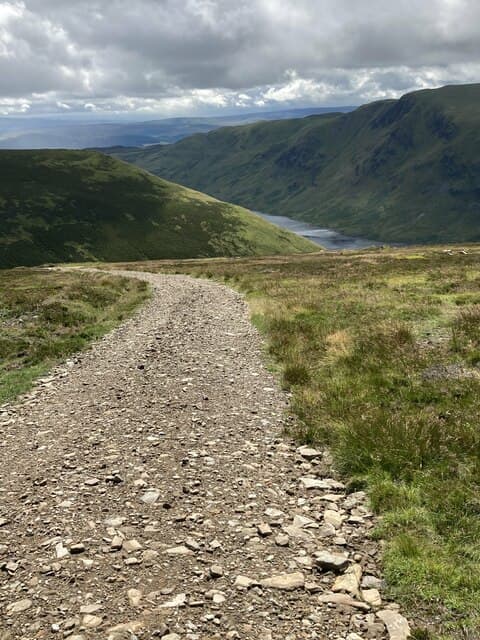
Park at the small layby on the minor road through the Sma' Glen near Newton Bridge (NN892323). A Land Rover estate track heads north-west into the hills, gaining height steadily through forestry and heather. After around 4km, branch off the track and head north-west up grassy ground onto the broad south-east ridge of Auchnafree Hill, finishing at a modest summit cairn. Allow 5–6 hours.
Terrain
Land Rover track for the first 4km — easy and quick. Above the track, the ground is heather and rough grass with peat hags in places. The summit plateau is broad and gently rounded with a small cairn. Drier than Highland Perthshire average thanks to the rain-shadow position. Easy navigation in clear weather; the broad summit can be confusing in cloud.
In winter
A good winter Corbett for parties wanting a friendlier eastern day. Snow comes late and goes early on these lower hills, but cold cover from January through February is common. The estate track is reliably ploughed below the gate. The standard ascent line carries no avalanche risk.
Kit for this: the winter Munro kit list · which boots take crampons
Best time of year
Getting there
- Glasgow2h 38m
- Edinburgh2h 43m
OS maps: OS Landranger 52
Mobile signal: Reasonable EE/Vodafone in the Sma' Glen; signal weakens on the lower track but recovers on top looking south
Current conditions
Daylight Today
- Sunrise
- 07:45
- Sunset
- 18:19
- Civil dawn
- 07:07
- Civil dusk
- 18:57
NOAA Solar Calculator · 14 October 2026
Pair with
Curated multi-hill combinations from Auchnafree Hill.
On a long-distance route
Auchnafree Hill sits within 5km of these named long-distance walks — useful for trail-pack rest days or section extensions.
Around Auchnafree Hill on the SCOT network
Getting there, basing yourself, and what to do off the hill.
Getting there: Gleneagles station
Glen Devon; Ochil ridges; Auchterarder; PGA Centenary course access
22km from the hill
tripscot.co.uk
On TripSCOTBase yourself in Aberfeldy
Loch Tay base — Ben Lawers, Tarmachan ridge, Birks of Aberfeldy
19km from the hill
tripscot.co.uk
On TasteSCOTAfter the hill: The Glenturret
Crieff — Scotland's oldest working distillery; Famous Grouse Experience
8km from the hill
tastescot.co.uk
Auchnafree Hill — common questions
- What difficulty is Auchnafree Hill?
- On the OutdoorSCOT scale, Auchnafree Hill comes in at 2/5 — moderate. Expect roughly 13km and 620m of ascent on the usual route — 3-5 hours for most parties. Terrain: Land Rover track for the first 4km — easy and quick.
- How prominent is Auchnafree Hill?
- Auchnafree Hill has 212m of topographic prominence — the height of its summit above the highest col connecting it to higher ground.
- Where should I park to climb Auchnafree Hill?
- Standard parking is at NN892323. Check the parking grid reference on an OS map before travel; informal laybys can fill on summer weekends.
- When should I climb Auchnafree Hill?
- The standard good-weather months for Auchnafree Hill are April, May, June, July, August, September, October. Outside those months, expect winter conditions on the high ground — full mountain kit, navigation skills, and a check of the SAIS avalanche forecast for the relevant region.
- Can I bring my dog up Auchnafree Hill?
- On a lead only — the route crosses ground with livestock or nesting-bird interest.
- What's mobile reception like on Auchnafree Hill?
- Reasonable EE/Vodafone in the Sma' Glen; signal weakens on the lower track but recovers on top looking south
- Is Auchnafree Hill safe in winter?
- A good winter Corbett for parties wanting a friendlier eastern day. Snow comes late and goes early on these lower hills, but cold cover from January through February is common. The estate track is reliably ploughed below the gate. The standard ascent line carries no avalanche risk.
Get the OutdoorSCOT weekly
One email a week — new route, hill and bothy guides, seasonal conditions and the odd hard-won lesson. No spam, unsubscribe in one click.