Corbett · Fife & Perthshire
Meall Tairneachan
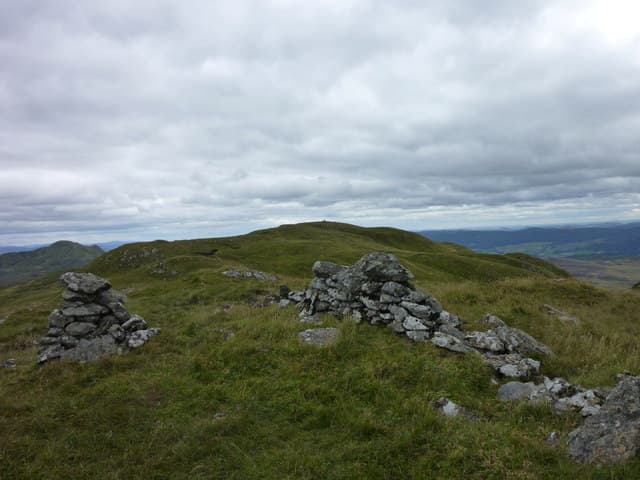
Meall Tairneachan — "the thunder hill" — is a rounded 787m Corbett north of Aberfeldy, between Loch Tummel and the Tay valley. With 420m of prominence it stands clearly above its neighbours and gives a trig-pointed summit on a wide grassy dome. The hill is unusual in carrying an active barytes mine on its southern flank — the Foss mine — one of only two industrial sites of its kind in Britain. The view south to Loch Tay and west to Schiehallion is among the finest moderate-hill panoramas in central Perthshire.
Quick facts
- Height
- 787m/ 2582ft
- Prominence
- 420 m
- Distance
- 14 km
- Ascent
- 645 m
- Time
- 4–7 hrs
- Grid ref
- NN807543
- Parking
- NN790551
- Nearest city
- Perth· 44km
- Dogs
- Dogs on lead required near livestockDog-friendly guide ↗
Height and prominence cross-checked against the Database of British and Irish Hills (CC BY).
No GPX track yet
Walked this route? Share your track to help other walkers.
Standard route
mine track 35% · rough hillside 30% · mossy ridge 25% · trig point 10%
Start from the small parking area off the B846 at Foss on the south shore of Loch Tummel. Follow the mine access track south-west around the Foss workings, then leave it and climb pathless heather and grass slopes onto the broad east ridge of Meall Tairneachan. Around 14km return with 645m of ascent. Often combined with neighbouring Farragon Hill across the bealach for a Perthshire double.
Terrain
The Foss mine track is firm gravel — bike-able as far as the workings. Off the track the ground is rough heather and grass with no path; the climb is gentle but slow. The summit dome is mossy turf with the trig pillar at the highest point. No exposure or scrambling. Stay clear of the active mine workings on the south flank.
In winter
A friendly winter Corbett — gentle gradients, no avalanche slopes and no cornicing of consequence. The B846 along Loch Tummel is gritted and reliable. The summit dome catches easterly snowfall in the Perthshire weather pattern. Daylight is short but the short approach makes a single hill manageable.
Best time of year
Getting there
- Glasgow2h 57m
- Edinburgh2h 57m
OS maps: OS Landranger 52
Mobile signal: Reasonable signal along Loch Tummel; intermittent on the summit
Current conditions
Daylight Today
- Sunrise
- 04:43
- Sunset
- 22:00
- Civil dawn
- 03:43
- Civil dusk
- 23:00
NOAA Solar Calculator · 13 July 2026
Around Meall Tairneachan on the SCOT network
Getting there, basing yourself, and what to do off the hill.
Getting there: Blair Atholl station
Beinn a Ghlo; Glen Tilt corridor north to the Cairngorms
13km from the hill
tripscot.co.uk
On TripSCOTBase yourself in Aberfeldy
Loch Tay base — Ben Lawers, Tarmachan ridge, Birks of Aberfeldy
7km from the hill
tripscot.co.uk
On TasteSCOTAfter the hill: Aberfeldy
Aberfeldy — heart of Dewar's blends; honey-and-heather Highland style
8km from the hill
tastescot.co.uk
Meall Tairneachan — common questions
- What difficulty is Meall Tairneachan?
- On the OutdoorSCOT scale, Meall Tairneachan comes in at 2/5 — moderate. Expect roughly 14km and 645m of ascent on the usual route — 4-7 hours for most parties. Underfoot: The Foss mine track is firm gravel — bike-able as far as the workings.
- What is Meall Tairneachan's prominence?
- 420m of prominence. That's the vertical drop from the summit to the col that links Meall Tairneachan to the next higher ground.
- Where do I park for Meall Tairneachan?
- Most walkers start from NN790551. Verify the grid reference on an OS map before you set off — space is tight on busy summer weekends.
- When is the best time to climb Meall Tairneachan?
- April, May, June, July, August, September, October give the most reliable conditions on Meall Tairneachan. Beyond that window the high ground turns wintry: carry full mountain kit, be confident navigating, and check the SAIS avalanche forecast for the area.
- Is Meall Tairneachan dog-friendly?
- Yes, but dogs must be kept on a lead — there is livestock or ground-nesting bird interest on the route.
- Is there mobile signal on Meall Tairneachan?
- Reasonable signal along Loch Tummel; intermittent on the summit
- Is Meall Tairneachan safe in winter?
- A friendly winter Corbett — gentle gradients, no avalanche slopes and no cornicing of consequence. The B846 along Loch Tummel is gritted and reliable. The summit dome catches easterly snowfall in the Perthshire weather pattern. Daylight is short but the short approach makes a single hill manageable.
Get the OutdoorSCOT weekly
One email a week — new route, hill and bothy guides, seasonal conditions and the odd hard-won lesson. No spam, unsubscribe in one click.