Corbett · Fife & Perthshire
Farragon Hill
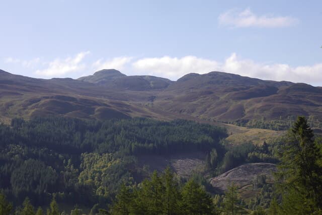
Farragon Hill is the rounded 782m Corbett rising north of Loch Tummel above the small village of Foss, between Pitlochry and Tummel Bridge. The mountain is named for Saint Fearchar, an early Christian who is said to have established a cell on the hill. Mineral interest is also part of its history: the Farragon vein, mined for galena and barytes in the 18th and 19th centuries, runs through the hill and was once a small but locally important source of lead. A friendly Perthshire hill day with views south to Schiehallion and east toward Beinn a' Ghlò.
Quick facts
- Height
- 782.4m/ 2567ft
- Prominence
- 186 m
- Distance
- 12 km
- Ascent
- 650 m
- Time
- 3–5 hrs
- Grid ref
- NN840553
- Parking
- NN790566
- Nearest city
- Perth· 42km
- Dogs
- Dogs on lead required near livestockDog-friendly guide ↗
Height and prominence cross-checked against the Database of British and Irish Hills (CC BY).
No GPX track yet
Walked this route? Share your track to help other walkers.
Standard route
estate track 25% · heather moorland 45% · grassy upper slopes 20% · summit area 10%
Start from the parking pull-off on the Foss road above the north shore of Loch Tummel (NN790566). Follow the estate track north for about 3km — steady climbing through commercial plantation before the trees give out onto open hillside. Strike off the track to the north-east, working over short heather to gain Farragon's broad south flank and the summit cairn at the high point. About 4.5–5.5 hours all in.
Terrain
Plantation track lower down. Once above the tree line the underlying ground is short heather and turf — drier than Perthshire average thanks to the Tummel rain shadow. The high point is wide and gently rolling with a small cairn. Watch for old mine workings on the south flank — a reminder of the 18th- and 19th-century galena workings.
In winter
A friendly winter Corbett — gradients are gentle, the broad ridge is hard to lose under cover, and there is no exposure on the summit area. Snow comes through January and February. Cold easterlies funnelling down the Tummel valley can be brutal; bring proper insulation. The Foss road stays driveable through most winters.
Best time of year
Getting there
- Glasgow2h 59m
- Edinburgh2h 57m
OS maps: OS Landranger 52
Mobile signal: Intermittent signal near Aberfeldy; 1-2 bars at the cairn
Current conditions
Daylight Today
- Sunrise
- 04:49
- Sunset
- 21:55
- Civil dawn
- 03:51
- Civil dusk
- 22:52
NOAA Solar Calculator · 17 July 2026
Pair with
Curated multi-hill combinations from Farragon Hill.
Around Farragon Hill on the SCOT network
Getting there, basing yourself, and what to do off the hill.
Getting there: Blair Atholl station
Beinn a Ghlo; Glen Tilt corridor north to the Cairngorms
11km from the hill
tripscot.co.uk
On TripSCOTBase yourself in Aberfeldy
Loch Tay base — Ben Lawers, Tarmachan ridge, Birks of Aberfeldy
6km from the hill
tripscot.co.uk
On TasteSCOTAfter the hill: Aberfeldy
Aberfeldy — heart of Dewar's blends; honey-and-heather Highland style
7km from the hill
tastescot.co.uk
Farragon Hill — common questions
- What difficulty is Farragon Hill?
- On the OutdoorSCOT scale, Farragon Hill comes in at 2/5 — moderate. Expect roughly 12km and 650m of ascent on the usual route — 3-5 hours for most parties. Underfoot: Plantation track lower down.
- What is Farragon Hill's prominence?
- 186m of prominence. That's the vertical drop from the summit to the col that links Farragon Hill to the next higher ground.
- Where do I park for Farragon Hill?
- Most walkers start from NN790566. Verify the grid reference on an OS map before you set off — space is tight on busy summer weekends.
- When is the best time to climb Farragon Hill?
- April, May, June, July, August, September, October give the most reliable conditions on Farragon Hill. Beyond that window the high ground turns wintry: carry full mountain kit, be confident navigating, and check the SAIS avalanche forecast for the area.
- Is Farragon Hill dog-friendly?
- Yes, but dogs must be kept on a lead — there is livestock or ground-nesting bird interest on the route.
- Is there mobile signal on Farragon Hill?
- Intermittent signal near Aberfeldy; 1-2 bars at the cairn
- Is Farragon Hill safe in winter?
- A friendly winter Corbett — gradients are gentle, the broad ridge is hard to lose under cover, and there is no exposure on the summit area. Snow comes through January and February. Cold easterlies funnelling down the Tummel valley can be brutal; bring proper insulation. The Foss road stays driveable through most winters.
Get the OutdoorSCOT weekly
One email a week — new route, hill and bothy guides, seasonal conditions and the odd hard-won lesson. No spam, unsubscribe in one click.