Munro · Fife & Perthshire
Schiehallion
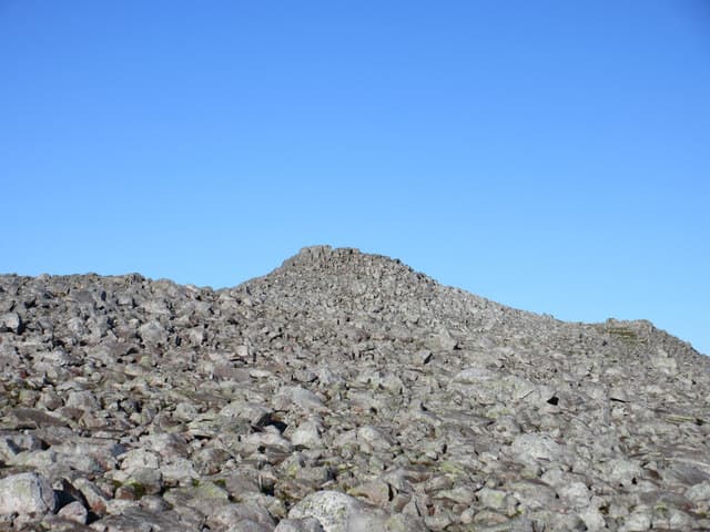
Schiehallion — "the fairy hill of the Caledonians" — is the 1083m Munro between Loch Rannoch and Glen Lyon, one of the most recognisable mountains in Scotland from its near-perfect conical profile when seen from the east. The hill carries scientific significance too: in 1774, Astronomer Royal Nevil Maskelyne used Schiehallion to make the first measurement of the Earth's mass, and his survey method gave rise to the modern technique of contour lines on maps. The summit is a small rocky crown on a wide stony top.
Quick facts
- Height
- 1083.3m/ 3554ft
- Prominence
- 716 m
- Distance
- 10 km
- Ascent
- 750 m
- Time
- 4–6 hrs
- Grid ref
- NN713547
- Parking
- NN754557
- Nearest city
- Perth· 51km
- Dogs
- Dogs on lead required near livestockDog-friendly guide ↗
Height and prominence cross-checked against the Database of British and Irish Hills (CC BY).
No GPX track yet
Walked this route? Share your track to help other walkers.
Standard route
Good path to mid-mountain 35% · Quartzite boulder field 50% · Summit 15%
The standard line is the John Muir Trust path from the Braes of Foss car park, climbing the east ridge of the hill on a well-built path through the JMT estate land. The lower section is flagstoned gravel; the upper third turns to a vast field of quartzite boulders that walkers must hop across to reach the summit. Around 10km return with 750m of ascent.
Terrain
The John Muir Trust restoration on the east ridge sets a benchmark for upland path engineering — neat flagstones carry walkers up the steep lower section. The upper third is a quartzite boulder field that demands careful footwork; in mist navigation across this requires GPS or precise bearings. The summit is a small rocky crown with the cairn unmistakable in clear weather. The popularity of the hill has caused significant path erosion; stay on the marked route.
In winter
A popular winter Munro by Perthshire standards. The upper boulder field becomes a serious snow-and-ice traverse — boulders mask under fresh snow and the gradient is sustained. Cornicing on the north sides above Gleann Mor. The Foss car park is gritted and reliable; the B846 is generally clear. SAIS Southern Cairngorms applies.
Best time of year
Getting there
- Glasgow2h 55m
- Edinburgh2h 4m
OS maps: OS Landranger 42, OS Landranger 51, OS Landranger 52
Mobile signal: Good signal at the Schiehallion car park near Braes of Foss. Signal weakens above 800m. Save maps ahead of setting off — the upper mountain is broad and featureless.
Current conditions
Daylight Today
- Sunrise
- 05:00
- Sunset
- 21:46
- Civil dawn
- 04:05
- Civil dusk
- 22:41
NOAA Solar Calculator · 23 July 2026
Pair with
Curated multi-hill combinations from Schiehallion.
Around Schiehallion on the SCOT network
Getting there, basing yourself, and what to do off the hill.
Getting there: Blair Atholl station
Beinn a Ghlo; Glen Tilt corridor north to the Cairngorms
19km from the hill
tripscot.co.uk
On TripSCOTBase yourself in Aberfeldy
Loch Tay base — Ben Lawers, Tarmachan ridge, Birks of Aberfeldy
15km from the hill
tripscot.co.uk
On TasteSCOTAfter the hill: Aberfeldy
Aberfeldy — heart of Dewar's blends; honey-and-heather Highland style
16km from the hill
tastescot.co.uk
Schiehallion — common questions
- How hard is Schiehallion?
- We grade Schiehallion at 4/5, which puts it in challenging territory. The usual route is around 10km with 750m of climbing; allow 4-6 hours. Ground conditions: The John Muir Trust restoration on the east ridge sets a benchmark for upland path engineering — neat flagstones carry walkers up the steep lower section.
- How much drop does Schiehallion have?
- The drop is 716m: measured from the summit of Schiehallion down to the saddle joining it to higher terrain.
- Where's the parking for Schiehallion?
- Park at NN754557. Double-check the grid reference on an OS map first; informal laybys here fill early in high season.
- What's the best month to climb Schiehallion?
- Aim for May, June, July, August, September, October on Schiehallion. In the remaining months treat it as a winter hill — full kit, solid navigation, and a look at the relevant SAIS avalanche forecast before you go.
- Can dogs go up Schiehallion?
- Dogs are fine on a lead. The route passes livestock or ground-nesting bird habitat, so keep them close throughout.
- Will I get phone signal on Schiehallion?
- Good signal at the Schiehallion car park near Braes of Foss. Signal weakens above 800m. Save maps ahead of setting off — the upper mountain is broad and featureless.
- Is Schiehallion safe in winter?
- A popular winter Munro by Perthshire standards. The upper boulder field becomes a serious snow-and-ice traverse — boulders mask under fresh snow and the gradient is sustained. Cornicing on the north sides above Gleann Mor. The Foss car park is gritted and reliable; the B846 is generally clear. SAIS Southern Cairngorms applies.
Get the OutdoorSCOT weekly
One email a week — new route, hill and bothy guides, seasonal conditions and the odd hard-won lesson. No spam, unsubscribe in one click.