Munro · Fife & Perthshire
Carn Gorm
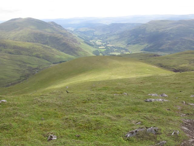
Càrn Gorm (1029m) is the westernmost Munro of the Càrn Mairg group of four — the long ridge that walls in the northern side of Glen Lyon. The hill is the natural first summit of the classic four-Munro round from Invervar, with a long sustained pull up the south ridge to a flat-topped summit. Càrn Gorm is itself a fine viewpoint west over Glen Lyon to Schiehallion and south to the Ben Lawers range.
Quick facts
- Height
- 1029.5m/ 3378ft
- Prominence
- 189 m
- Distance
- 17 km
- Ascent
- 906 m
- Time
- 5–8 hrs
- Grid ref
- NN635500
- Parking
- NN666483
- Nearest city
- Perth· 55km
- Dogs
- Dogs on lead required near livestockDog-friendly guide ↗
Height and prominence cross-checked against the Database of British and Irish Hills (CC BY).
No GPX track yet
Walked this route? Share your track to help other walkers.
Standard route
Glen track 25% · Open hillside 45% · Summit ridge 30%
Park at the Invervar lay-by on the north side of Glen Lyon. Take the Invervar Burn path north, then climb west onto the broad south ridge of Càrn Gorm — a sustained climb on heather and short grass. The summit is a small cairn on a flat mossy top. Most parties continue east over Meall Garbh, Càrn Mairg and Meall na Aighean for the full four-Munro round. Càrn Gorm alone is 9km with 850m of ascent.
Terrain
The lower Invervar Burn track is firm peat for the opening kilometre, then the climb onto the south ridge becomes pathless heathery hillside until the broader ridge takes over. Above 800m the surface turns to mossy turf and short grass — easy underfoot but featureless. The summit is a flat mossy top with a small cairn. The connecting ridge east to Meall Garbh and beyond is broad and undulating.
In winter
A relatively benign Càrn Mairg group winter day. The broad south ridge of Càrn Gorm gathers wind-blown snow but is seldom avalanche-prone. The summit area drifts heavily. All four summits build persistent cornices on their north flanks. Driving up Glen Lyon involves a narrow single-track road which can be drifted; consult SAIS Southern Cairngorms as the nearest regional indicator. Phone signal in Glen Lyon is reasonable but absent on the tops.
Best time of year
Getting there
- Glasgow2h 48m
- Edinburgh2h 5m
OS maps: OS Landranger 42, OS Landranger 51
Mobile signal: Reasonable signal in Innerwick or Invervar. Signal weakens above 800m. Download maps before the trip up Glen Lyon.
Current conditions
Daylight Today
- Sunrise
- 05:01
- Sunset
- 21:46
- Civil dawn
- 04:06
- Civil dusk
- 22:41
NOAA Solar Calculator · 23 July 2026
Pair with
Curated multi-hill combinations from Carn Gorm.
Around Carn Gorm on the SCOT network
Getting there, basing yourself, and what to do off the hill.
Getting there: Rannoch station
Rannoch Moor — remote West Highland Line stop; Schiehallion approach via bus
23km from the hill
tripscot.co.uk
On TripSCOTBase yourself in Aberfeldy
Loch Tay base — Ben Lawers, Tarmachan ridge, Birks of Aberfeldy
22km from the hill
tripscot.co.uk
On TasteSCOTAfter the hill: Aberfeldy
Aberfeldy — heart of Dewar's blends; honey-and-heather Highland style
22km from the hill
tastescot.co.uk
Carn Gorm — common questions
- What difficulty is Carn Gorm?
- On the OutdoorSCOT scale, Carn Gorm comes in at 4/5 — challenging. Expect roughly 17km and 906m of ascent on the usual route — 5-8 hours for most parties. Underfoot: The lower Invervar Burn track is firm peat for the opening kilometre, then the climb onto the south ridge becomes pathless heathery hillside until the broader ridge takes over.
- What is Carn Gorm's prominence?
- 189m of prominence. That's the vertical drop from the summit to the col that links Carn Gorm to the next higher ground.
- Where do I park for Carn Gorm?
- Most walkers start from NN666483. Verify the grid reference on an OS map before you set off — space is tight on busy summer weekends.
- When is the best time to climb Carn Gorm?
- May, June, July, August, September, October give the most reliable conditions on Carn Gorm. Beyond that window the high ground turns wintry: carry full mountain kit, be confident navigating, and check the SAIS avalanche forecast for the area.
- Is Carn Gorm dog-friendly?
- Yes, but dogs must be kept on a lead — there is livestock or ground-nesting bird interest on the route.
- Is there mobile signal on Carn Gorm?
- Reasonable signal in Innerwick or Invervar. Signal weakens above 800m. Download maps before the trip up Glen Lyon.
- Is Carn Gorm safe in winter?
- A relatively benign Càrn Mairg group winter day. The broad south ridge of Càrn Gorm gathers wind-blown snow but is seldom avalanche-prone. The summit area drifts heavily. All four summits build persistent cornices on their north flanks. Driving up Glen Lyon involves a narrow single-track road which can be drifted; consult SAIS Southern Cairngorms as the nearest regional indicator. Phone signal in Glen Lyon is reasonable but absent on the tops.
Get the OutdoorSCOT weekly
One email a week — new route, hill and bothy guides, seasonal conditions and the odd hard-won lesson. No spam, unsubscribe in one click.