Munro · Fife & Perthshire
Carn Mairg
Càrn Mairg (1043m) is the highest of the four Munros of the Càrn Mairg group, the long ridge of summits that walls in the northern side of Glen Lyon — Scotland's longest enclosed glen. The group also includes Meall Garbh, Càrn Gorm and Meall na Aighean (Creag Mhòr), and the full traverse takes in all four with a long high-level ridge connecting them. The hills are mossy and grassy in character rather than rocky, offering one of the most enjoyable horseshoe rounds in southern Scotland.
Quick facts
- Height
- 1043m/ 3422ft
- Prominence
- 467 m
- Distance
- 17 km
- Ascent
- 918 m
- Time
- 5–8 hrs
- Grid ref
- NN684512
- Parking
- NN666483
- Nearest city
- Perth· 51km
- Dogs
- Dogs on lead required near livestockDog-friendly guide ↗
Height and prominence cross-checked against the Database of British and Irish Hills (CC BY).
No GPX track yet
Walked this route? Share your track to help other walkers.
Standard route
Glen Lyon track 25% · Open hillside 45% · Summit ridge 30%
Park at Invervar on the north side of Glen Lyon, west of Coshieville. Take the path north up the Invervar Burn, then climb west onto Càrn Gorm — the first Munro. Continue north and east over Meall Garbh and Meall a' Bharr, then north-east to Càrn Mairg. Drop south-east to the bealach and climb the final Munro, Meall na Aighean (Creag Mhòr), before descending the south ridge back to Invervar. Around 17km with 1300m of ascent for the full four-Munro round.
Terrain
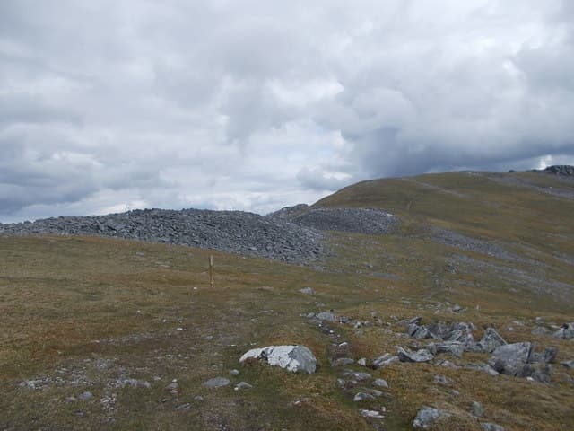
The Invervar Burn path is firm peaty track for the first kilometre, then deteriorates onto open hillside. The four summits are linked by broad mossy turf ridges that are pleasant under foot but undulate continuously — there is more re-ascent than the map suggests. The Càrn Mairg summit is a small cairn perched on a flat top covered with quartzite boulders. The descent off Meall na Aighean to Invervar is steep wet grass.
In winter
A long winter ridge traverse. The broad mossy summits drift deeply but offer few avalanche-prone slopes. The two deep bealachs collect wind-blown snow and can be tiring underfoot. Each of the four tops develops consistent cornicing along its northern flank. The Glen Lyon road is a narrow single-track route prone to drifts. Phone reception at Invervar is decent but disappears on the ridges. The nearest official avalanche forecast is SAIS Southern Cairngorms.
Best time of year
Getting there
- Glasgow2h 50m
- Edinburgh2h 3m
OS maps: OS Landranger 42, OS Landranger 51
Mobile signal: Reasonable signal at the Invervar car park in Glen Lyon. Signal thins beyond 800m. Grab maps before the journey up Glen Lyon.
Current conditions
Daylight Today
- Sunrise
- 05:00
- Sunset
- 21:46
- Civil dawn
- 04:06
- Civil dusk
- 22:40
NOAA Solar Calculator · 23 July 2026
Pair with
Curated multi-hill combinations from Carn Mairg.
Around Carn Mairg on the SCOT network
Getting there, basing yourself, and what to do off the hill.
Getting there: Blair Atholl station
Beinn a Ghlo; Glen Tilt corridor north to the Cairngorms
23km from the hill
tripscot.co.uk
On TripSCOTBase yourself in Aberfeldy
Loch Tay base — Ben Lawers, Tarmachan ridge, Birks of Aberfeldy
17km from the hill
tripscot.co.uk
On TasteSCOTAfter the hill: Aberfeldy
Aberfeldy — heart of Dewar's blends; honey-and-heather Highland style
18km from the hill
tastescot.co.uk
Carn Mairg — common questions
- Is Carn Mairg a hard climb?
- Carn Mairg is rated 4/5 (challenging) on the OutdoorSCOT scale. The standard route covers about 17km with 918m of ascent and takes most walkers 5-8 hours. Terrain: The Invervar Burn path is firm peaty track for the first kilometre, then deteriorates onto open hillside.
- How prominent is Carn Mairg?
- Carn Mairg has 467m of topographic prominence — the height of its summit above the highest col connecting it to higher ground.
- Where should I park to climb Carn Mairg?
- Standard parking is at NN666483. Check the parking grid reference on an OS map before travel; informal laybys can fill on summer weekends.
- When should I climb Carn Mairg?
- The standard good-weather months for Carn Mairg are May, June, July, August, September, October. Outside those months, expect winter conditions on the high ground — full mountain kit, navigation skills, and a check of the SAIS avalanche forecast for the relevant region.
- Can I bring my dog up Carn Mairg?
- On a lead only — the route crosses ground with livestock or nesting-bird interest.
- What's mobile reception like on Carn Mairg?
- Reasonable signal at the Invervar car park in Glen Lyon. Signal thins beyond 800m. Grab maps before the journey up Glen Lyon.
- Is Carn Mairg safe in winter?
- A long winter ridge traverse. The broad mossy summits drift deeply but offer few avalanche-prone slopes. The two deep bealachs collect wind-blown snow and can be tiring underfoot. Each of the four tops develops consistent cornicing along its northern flank. The Glen Lyon road is a narrow single-track route prone to drifts. Phone reception at Invervar is decent but disappears on the ridges. The nearest official avalanche forecast is SAIS Southern Cairngorms.
Get the OutdoorSCOT weekly
One email a week — new route, hill and bothy guides, seasonal conditions and the odd hard-won lesson. No spam, unsubscribe in one click.