Graham · Fife & Perthshire
Creag Each
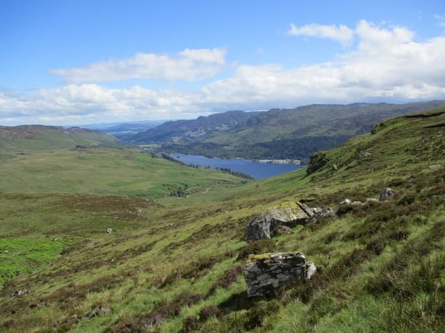
Creag Each (673m) — the horse crag — sits north of Comrie in Glen Lednock in the NN62 square, a craggy little summit on the Highland edge of southern Perthshire. The rocky prominence above the cairn looks south over Strathearn to the Ochils and north into the heart of the Breadalbane group, with the cleft of the Devil's Cauldron visible far below.
Quick facts
- Height
- 673.7m/ 2210ft
- Prominence
- 218 m
- Distance
- 13 km
- Ascent
- 552 m
- Time
- 3–6 hrs
- Grid ref
- NN652263
- Parking
- NN645281
- Nearest city
- Stirling· 36km
- Dogs
- Dogs on lead required near livestockDog-friendly guide ↗
Height and prominence cross-checked against the Database of British and Irish Hills (CC BY).
No GPX track yet
Walked this route? Share your track to help other walkers.
Standard route
heather moorland 60% · grass slopes 30% · rocky summit 10%
Start at the Glen Lednock car park beside the Devil's Cauldron above Comrie. Take the path past the Cauldron viewpoint and continue up the glen to where a stalkers track climbs west onto the Auchnafree hillside. Strike north onto the heather slopes of Creag Each, picking a line through outcrops to the summit prominence with its small cairn.
Terrain
Comrie woodland path, then estate track at a steady gradient, then heather and outcrop on the open hillside. The summit is a small rocky knoll above a heather plateau; a short hands-on step at the very top adds a little character.
In winter
Southern Perthshire snow tends to be thin and crusted. Creag Each picks up wind-drifted cover on its north-facing crags and the summit step ices over readily. The Glen Lednock road is rarely treacherous, making this a useful winter option when the bigger hills are not in condition.
Best time of year
Getting there
- Glasgow1h 27m
- Edinburgh2h 54m
OS maps: OS Landranger 51
Mobile signal: Poor. Remote north Perthshire; limited signal on most networks.
Current conditions
Daylight Today
- Sunrise
- 04:46
- Sunset
- 21:59
- Civil dawn
- 03:47
- Civil dusk
- 22:58
NOAA Solar Calculator · 13 July 2026
Around Creag Each on the SCOT network
Getting there, basing yourself, and what to do off the hill.
Getting there: Crianlarich station
Crianlarich Munros — Ben More, Stob Binnein, Ben Lui, Cruach Ardrain
27km from the hill
tripscot.co.uk
On TripSCOTBase yourself in Callander
Trossachs gateway — Ben Ledi, Stuc a Chroin, Rob Roy Way
18km from the hill
tripscot.co.uk
On TasteSCOTAfter the hill: The Glenturret
Crieff — Scotland's oldest working distillery; Famous Grouse Experience
19km from the hill
tastescot.co.uk
Creag Each — common questions
- What difficulty is Creag Each?
- On the OutdoorSCOT scale, Creag Each comes in at 3/5 — moderately challenging. Expect roughly 13km and 552m of ascent on the usual route — 3-6 hours for most parties. Ground conditions: Comrie woodland path, then estate track at a steady gradient, then heather and outcrop on the open hillside.
- How much drop does Creag Each have?
- The drop is 218m: measured from the summit of Creag Each down to the saddle joining it to higher terrain.
- Where's the parking for Creag Each?
- Park at NN645281. Double-check the grid reference on an OS map first; informal laybys here fill early in high season.
- What's the best month to climb Creag Each?
- Aim for March, April, May, June, July, August, September, October, November on Creag Each. In the remaining months treat it as a winter hill — full kit, solid navigation, and a look at the relevant SAIS avalanche forecast before you go.
- Can dogs go up Creag Each?
- Dogs are fine on a lead. The route passes livestock or ground-nesting bird habitat, so keep them close throughout.
- Will I get phone signal on Creag Each?
- Poor. Remote north Perthshire; limited signal on most networks.
- Is Creag Each safe in winter?
- Southern Perthshire snow tends to be thin and crusted. Creag Each picks up wind-drifted cover on its north-facing crags and the summit step ices over readily. The Glen Lednock road is rarely treacherous, making this a useful winter option when the bigger hills are not in condition.
Get the OutdoorSCOT weekly
One email a week — new route, hill and bothy guides, seasonal conditions and the odd hard-won lesson. No spam, unsubscribe in one click.