Munro · Arrochar & Trossachs
Ben Vorlich
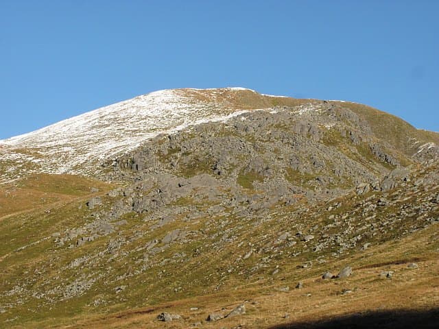
Ben Vorlich (985m) — the Loch Earn version, not the Loch Lomond Munro of the same name — is a shapely conical Munro rising directly above the south side of Loch Earn near Lochearnhead. Together with its lower companion Stuc a' Chroin to the west, it forms one of the most popular Southern Highlands Munro pairs, easily accessible from Edinburgh and Glasgow. The summit gives commanding views over Loch Earn, the Ochil Hills and as far south as the Pentlands on clear days.
Quick facts
- Height
- 985.3m/ 3233ft
- Prominence
- 834 m
- Distance
- ~17 km
- Ascent
- ~867 m
- Time
- 5–8 hrs
- Grid ref
- NN629189
- Parking
- NN632232
- Nearest city
- Stirling· 31km
- Dogs
- Dogs on lead required near livestockDog-friendly guide ↗
Height and prominence cross-checked against the Database of British and Irish Hills (CC BY).
No GPX track yet
Walked this route? Share your track to help other walkers.
Standard route
Path / open hillside 45% · Steep hillside 35% · Summit area 20%
Park at the Ardvorlich Estate car park on the south side of Loch Earn (small charge). Take the well-built path south from the loch, climbing the steep north ridge of Ben Vorlich to the trig pillar at the summit. Most parties continue west and south to Stuc a' Chroin via the deep Bealach an Dubh Choirein — a steep rocky bealach with one short scrambly step. Around 11km with 1100m of ascent for the pair; Ben Vorlich alone is 8km with 940m up.
Terrain
The Ardvorlich estate path is well-built stone pitching for the lower section. Ben Vorlich's north ridge is sustained heathery hillside with a clear, eroded path. Above 700m the surface becomes short grass and broken rock leading to the trig pillar. The Bealach an Dubh Choirein between Vorlich and Stuc a' Chroin is a deep bealach with steep ground both sides — the climb onto Stuc a' Chroin involves one short scrambly section. The descent off Stuc to Glen Ample is steep grass.
In winter
A genuinely mid-grade winter outing for Southern Highlands standards. Ben Vorlich's north ridge sits exposed to easterly weather. The Bealach an Dubh Choirein scramble onto Stuc a' Chroin becomes a Grade I winter scramble. The A85 corridor at Lochearnhead stays gritted. Phone signal on lower slopes is reasonable; fades above 700m.
Kit for this: the winter Munro kit list · which boots take crampons
Best time of year
Getting there
- Glasgow1h 17m
- Edinburgh2h 50m
OS maps: OS Landranger 57
Mobile signal: Good EE/Vodafone signal at Ardlui and along the A82. Signal maintained on lower slopes; weakens above 700m. Popular hill with good road access.
Current conditions
Daylight Today
- Sunrise
- 08:03
- Sunset
- 18:00
- Civil dawn
- 07:24
- Civil dusk
- 18:39
NOAA Solar Calculator · 22 October 2026
Ben Vorlich weather: forecast, wind exposure and winter notes →
On a long-distance route
Ben Vorlich sits within 5km of these named long-distance walks — useful for trail-pack rest days or section extensions.
Around Ben Vorlich on the SCOT network
Getting there, basing yourself, and what to do off the hill.
Getting there: Dunblane station
Stirling-area; Sheriffmuir; gateway north
24km from the hill
tripscot.co.uk
On TripSCOTBase yourself in Callander
Trossachs gateway — Ben Ledi, Stuc a Chroin, Rob Roy Way
11km from the hill
tripscot.co.uk
On TasteSCOTAfter the hill: Deanston
Doune — converted cotton mill; floral, honeyed Perthshire distillery
21km from the hill
tastescot.co.uk
Ben Vorlich — common questions
- Is Ben Vorlich a hard climb?
- Ben Vorlich is rated 4/5 (challenging) on the OutdoorSCOT scale. The standard route covers about 17km with 867m of ascent and takes most walkers 5-8 hours. Terrain: The Ardvorlich estate path is well-built stone pitching for the lower section.
- How prominent is Ben Vorlich?
- Ben Vorlich has 834m of topographic prominence — the height of its summit above the highest col connecting it to higher ground.
- Where should I park to climb Ben Vorlich?
- Standard parking is at NN632232. Check the parking grid reference on an OS map before travel; informal laybys can fill on summer weekends.
- When should I climb Ben Vorlich?
- The standard good-weather months for Ben Vorlich are May, June, July, August, September, October. Outside those months, expect winter conditions on the high ground — full mountain kit, navigation skills, and a check of the SAIS avalanche forecast for the relevant region.
- Can I bring my dog up Ben Vorlich?
- On a lead only — the route crosses ground with livestock or nesting-bird interest.
- What's mobile reception like on Ben Vorlich?
- Good EE/Vodafone signal at Ardlui and along the A82. Signal maintained on lower slopes; weakens above 700m. Popular hill with good road access.
- Is Ben Vorlich safe in winter?
- A genuinely mid-grade winter outing for Southern Highlands standards. Ben Vorlich's north ridge sits exposed to easterly weather. The Bealach an Dubh Choirein scramble onto Stuc a' Chroin becomes a Grade I winter scramble. The A85 corridor at Lochearnhead stays gritted. Phone signal on lower slopes is reasonable; fades above 700m.
Get the OutdoorSCOT weekly
One email a week — new route, hill and bothy guides, seasonal conditions and the odd hard-won lesson. No spam, unsubscribe in one click.