Munro · Arrochar & Trossachs
Ben More
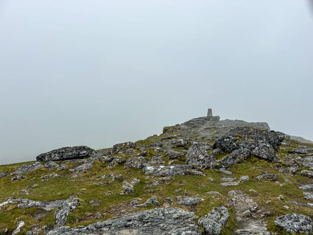
Ben More (Crianlarich) is the 1174m Munro that dominates the view east from Crianlarich, the highest peak in the Southern Highlands and a defining feature of the central Highlands skyline. The hill is a near-perfect cone seen from the A85 — a relentlessly steep grass-and-rock ascent of 1000m from the road. With 986m of prominence it stands clear of its Munro twin Stob Binnein to the south by a deep bealach. The summit trig pillar gives one of the broadest views in Scotland: Mull and Jura west, the Cairngorms north-east, the Pentlands east.
Quick facts
- Height
- 1173.9m/ 3851ft
- Prominence
- 986 m
- Distance
- 19 km
- Ascent
- 1033 m
- Time
- 6–9 hrs
- Grid ref
- NN432244
- Parking
- NN414258
- Nearest city
- Stirling· 48km
- Dogs
- Dogs on lead required near livestockDog-friendly guide ↗
Height and prominence cross-checked against the Database of British and Irish Hills (CC BY).
No GPX track yet
Walked this route? Share your track to help other walkers.
Standard route
Farm track / open hillside 30% · Steep hillside 45% · Summit ridge 25%
The classic line is the Benmore Farm path from the A85 north-east of Crianlarich — a steep, unrelenting climb up the north-west face. Around 12km return with 1033m of ascent. Almost always combined with Stob Binnein 1km south via the high bealach — adding a Munro for little extra effort. Strong walkers continue south along the Ben More group ridge for a 3-Munro day. The direct face route is loose grass and rock; in wet conditions descents via the same line are slippery.
Terrain
The Benmore Farm path is firm at the bottom but degrades to rough grass and rocky steps as the gradient steepens. There is no scrambling on the standard line but the slope is sustained around 45 degrees in places; trekking poles are useful. The summit ridge is broad short turf with the trig pillar prominent. The connecting ridge to Stob Binnein drops to a wide bealach then climbs sustained grass.
In winter
A serious winter Munro. The steep north-west face is a major avalanche slope after westerly storms — there is a long history of incidents on the standard route. Cornices form along the summit ridge and on the connection to Stob Binnein. Crampons and axe essential; the gradient is steep enough to demand competent winter walking technique. SAIS Southern Cairngorms (the closest report) gives a regional guide.
This hill is in the Southern Highlands SAIS forecast area. Check SAIS forecasts in winter (December–April).
Best time of year
Getting there
- Glasgow1h 27m
- Edinburgh2h 3m
OS maps: OS Landranger 51
Mobile signal: Good EE/Vodafone signal at Benmore Farm car park on the A85. Signal maintained on the lower slopes, weakening above 900m. Summit sometimes has partial coverage.
Current conditions
Daylight Today
- Sunrise
- 05:03
- Sunset
- 21:46
- Civil dawn
- 04:10
- Civil dusk
- 22:40
NOAA Solar Calculator · 23 July 2026
Pair with
Curated multi-hill combinations from Ben More.
Around Ben More on the SCOT network
Getting there, basing yourself, and what to do off the hill.
Ben More — common questions
- How hard is Ben More?
- We grade Ben More at 3/5, which puts it in moderately challenging territory. The usual route is around 19km with 1033m of climbing; allow 6-9 hours. Terrain: The Benmore Farm path is firm at the bottom but degrades to rough grass and rocky steps as the gradient steepens.
- How prominent is Ben More?
- Ben More has 986m of topographic prominence — the height of its summit above the highest col connecting it to higher ground.
- Where should I park to climb Ben More?
- Standard parking is at NN414258. Check the parking grid reference on an OS map before travel; informal laybys can fill on summer weekends.
- When should I climb Ben More?
- The standard good-weather months for Ben More are May, June, July, August, September, October. Outside those months, expect winter conditions on the high ground — full mountain kit, navigation skills, and a check of the SAIS avalanche forecast for the relevant region.
- Can I bring my dog up Ben More?
- On a lead only — the route crosses ground with livestock or nesting-bird interest.
- What's mobile reception like on Ben More?
- Good EE/Vodafone signal at Benmore Farm car park on the A85. Signal maintained on the lower slopes, weakening above 900m. Summit sometimes has partial coverage.
- Is Ben More safe in winter?
- A serious winter Munro. The steep north-west face is a major avalanche slope after westerly storms — there is a long history of incidents on the standard route. Cornices form along the summit ridge and on the connection to Stob Binnein. Crampons and axe essential; the gradient is steep enough to demand competent winter walking technique. SAIS Southern Cairngorms (the closest report) gives a regional guide.
Get the OutdoorSCOT weekly
One email a week — new route, hill and bothy guides, seasonal conditions and the odd hard-won lesson. No spam, unsubscribe in one click.