Corbett · Arrochar & Trossachs
Stob a' Choin
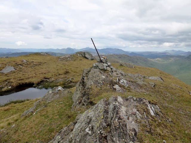
Stob a' Choin is the most westerly of the Balquhidder Corbetts — a rough, steep-sided hill rising above the head of Loch Doine in Rob Roy MacGregor country. The 867m summit is sharply pointed in profile but the upper hill is broken by rock outcrops and small craggy steps, and the walking is consistently rougher than the metrics suggest. Distinctly Trossachs in character: wooded glens, sudden rocky outcrops, and views east to Stob Binnein and Ben More that compete with anywhere in the southern Highlands.
Quick facts
- Height
- 867.2m/ 2845ft
- Prominence
- 478 m
- Distance
- 13 km
- Ascent
- 920 m
- Time
- 4–6 hrs
- Grid ref
- NN417159
- Parking
- NN445183
- Nearest city
- Stirling· 44km
- Dogs
- Dogs on lead required near livestockDog-friendly guide ↗
Height and prominence cross-checked against the Database of British and Irish Hills (CC BY).
No GPX track yet
Walked this route? Share your track to help other walkers.
Standard route
farm track 20% · heather path 35% · rocky ridge 35% · summit area 10%
Park at the end of the public road at Inverlochlarig (NN445183) — gates and signs are clear; respect the farm. Walk back along the road briefly, then climb south through farmland onto open hillside. The route picks up a faint path heading south-west onto the north-east ridge of Stob a' Choin, then climbs steadily over rough rocky ground to the summit. The descent retraces the line. A long-day option continues west toward Stob Invercarnaig and Beinn a' Choin for a Trossachs traverse. Allow 6–7 hours for Stob a' Choin alone.
Terrain
Farm track and rough sheep pasture on the lower slopes. The upper hill is craggy with multiple small rock steps and outcrops; route-finding through the rougher sections needs attention. Drainage is poor — boggy patches scattered through the heather. Rock is mica schist, slippery in any wet conditions.
In winter
Trossachs winter conditions are maritime and unpredictable. The rocky upper section ices up readily and the small steps become awkward under snow. Compared to the higher Munros nearby, Stob a' Choin holds snow patchily but the descent is committing once you're committed to the line. Best in firm consolidated cover or skip until spring.
This hill is in the Southern Highlands SAIS forecast area. Check SAIS forecasts in winter (December–April).
Best time of year
Getting there
- Glasgow1h 16m
- Edinburgh2h 0m
OS maps: OS Landranger 56
Mobile signal: Patchy in Balquhidder valley; weakens up Loch Doine and into the hill. Brief 4G on the summit looking south to the Lowlands
Current conditions
Daylight Today
- Sunrise
- 04:48
- Sunset
- 22:00
- Civil dawn
- 03:50
- Civil dusk
- 22:58
NOAA Solar Calculator · 13 July 2026
Pair with
Curated multi-hill combinations from Stob a' Choin.
Around Stob a' Choin on the SCOT network
Getting there, basing yourself, and what to do off the hill.
Stob a' Choin — common questions
- What difficulty is Stob a' Choin?
- On the OutdoorSCOT scale, Stob a' Choin comes in at 3/5 — moderately challenging. Expect roughly 13km and 920m of ascent on the usual route — 4-6 hours for most parties. Underfoot: Farm track and rough sheep pasture on the lower slopes.
- What is Stob a' Choin's prominence?
- 478m of prominence. That's the vertical drop from the summit to the col that links Stob a' Choin to the next higher ground.
- Where do I park for Stob a' Choin?
- Most walkers start from NN445183. Verify the grid reference on an OS map before you set off — space is tight on busy summer weekends.
- When is the best time to climb Stob a' Choin?
- May, June, July, August, September, October give the most reliable conditions on Stob a' Choin. Beyond that window the high ground turns wintry: carry full mountain kit, be confident navigating, and check the SAIS avalanche forecast for the area.
- Is Stob a' Choin dog-friendly?
- Yes, but dogs must be kept on a lead — there is livestock or ground-nesting bird interest on the route.
- Is there mobile signal on Stob a' Choin?
- Patchy in Balquhidder valley; weakens up Loch Doine and into the hill. Brief 4G on the summit looking south to the Lowlands
- Is Stob a' Choin safe in winter?
- Trossachs winter conditions are maritime and unpredictable. The rocky upper section ices up readily and the small steps become awkward under snow. Compared to the higher Munros nearby, Stob a' Choin holds snow patchily but the descent is committing once you're committed to the line. Best in firm consolidated cover or skip until spring.
Get the OutdoorSCOT weekly
One email a week — new route, hill and bothy guides, seasonal conditions and the odd hard-won lesson. No spam, unsubscribe in one click.