Graham · Arrochar & Trossachs
Stob Breac
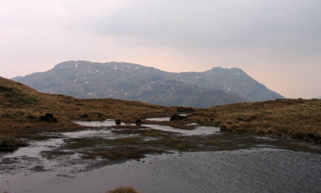
Stob Breac (686m) — the speckled peak — is a steep schist cone in the upper reaches of Glen Falloch, set in the NN41 square between Crianlarich and Balquhidder. Its mottled appearance from old quartzite veins in the schist gave the name. The summit shares a long ridge with the Munro An Caisteal and gives an unusual angle on Beinn Tulaichean and Cruach Ardrain.
Quick facts
- Height
- 686.4m/ 2252ft
- Prominence
- 248 m
- Distance
- 13 km
- Ascent
- 563 m
- Time
- 3–6 hrs
- Grid ref
- NN447166
- Parking
- NN438143
- Nearest city
- Stirling· 42km
- Dogs
- Dogs on lead required near livestockDog-friendly guide ↗
Height and prominence cross-checked against the Database of British and Irish Hills (CC BY).
No GPX track yet
Walked this route? Share your track to help other walkers.
Standard route
heather moorland 55% · bog and rushes 30% · grassy summit 15%
From the parking near Inverlochlarig at the end of the Balquhidder road follow the estate track west for 2km. Strike north up the steep grassy south flank to gain the long east ridge. The ridge is narrow and pleasant, leading to the small summit cairn after one steep pull through a schist band.
Terrain
Estate track, then a sharp grassy ascent on cropped turf. The east ridge is narrow and rocky in places, with one short schist band easily climbed in dry conditions. The summit area is a small turfy platform.
In winter
The southern Highlands catch heavy wet snow that ices the schist quickly. Stob Breac's narrow east ridge becomes a Grade I winter route in good cover. Avalanche risk on the steep north flank is real after fresh fall. SAIS Southern Cairngorms forecasts give the best read.
This hill is in the Southern Highlands SAIS forecast area. Check SAIS forecasts in winter (December–April).
Best time of year
Getting there
- Glasgow1h 16m
- Edinburgh2h 57m
OS maps: OS Landranger 57
Mobile signal: Weak. Remote Loch Treig area; signal is marginal here.
Current conditions
Daylight Today
- Sunrise
- 04:48
- Sunset
- 22:00
- Civil dawn
- 03:49
- Civil dusk
- 22:58
NOAA Solar Calculator · 13 July 2026
Around Stob Breac on the SCOT network
Getting there, basing yourself, and what to do off the hill.
Stob Breac — common questions
- What difficulty is Stob Breac?
- On the OutdoorSCOT scale, Stob Breac comes in at 3/5 — moderately challenging. Expect roughly 13km and 563m of ascent on the usual route — 3-6 hours for most parties. Terrain: Estate track, then a sharp grassy ascent on cropped turf.
- How prominent is Stob Breac?
- Stob Breac has 248m of topographic prominence — the height of its summit above the highest col connecting it to higher ground.
- Where should I park to climb Stob Breac?
- Standard parking is at NN438143. Check the parking grid reference on an OS map before travel; informal laybys can fill on summer weekends.
- When should I climb Stob Breac?
- The standard good-weather months for Stob Breac are March, April, May, June, July, August, September, October, November. Outside those months, expect winter conditions on the high ground — full mountain kit, navigation skills, and a check of the SAIS avalanche forecast for the relevant region.
- Can I bring my dog up Stob Breac?
- On a lead only — the route crosses ground with livestock or nesting-bird interest.
- What's mobile reception like on Stob Breac?
- Weak. Remote Loch Treig area; signal is marginal here.
- Is Stob Breac safe in winter?
- The southern Highlands catch heavy wet snow that ices the schist quickly. Stob Breac's narrow east ridge becomes a Grade I winter route in good cover. Avalanche risk on the steep north flank is real after fresh fall. SAIS Southern Cairngorms forecasts give the best read.
Get the OutdoorSCOT weekly
One email a week — new route, hill and bothy guides, seasonal conditions and the odd hard-won lesson. No spam, unsubscribe in one click.