Graham · Arrochar & Trossachs
Creag Mhor
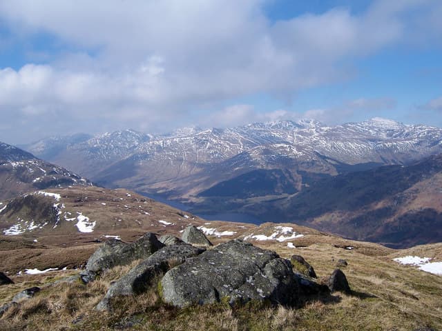
Creag Mhor (659m) — the big crag — is a craggy outlier of the Glen Finglas hills in the NN51 square, lying east of Brig o' Turk in the Trossachs. The rocky top looks down on Loch Drunkie and the Achray forest, with the Lawers range filling the northern skyline.
Gaelic: “crag, big” · Pronunciation: krayg vore
Quick facts
- Height
- 659.8m/ 2165ft
- Prominence
- 293 m
- Distance
- 13 km
- Ascent
- 540 m
- Time
- 3–6 hrs
- Grid ref
- NN510185
- Parking
- NN492182
- Nearest city
- Stirling· 38km
- Dogs
- Dogs on lead required near livestockDog-friendly guide ↗
Height and prominence cross-checked against the Database of British and Irish Hills (CC BY).
No GPX track yet
Walked this route? Share your track to help other walkers.
Standard route
heather and bracken 55% · grass slopes 30% · rocky summit 15%
Start from the Glen Finglas car park at Brig o' Turk and follow the Mell Brae circuit path east, then north. Leave the path at the bridge over the Allt a' Choin and climb the rough south-west spur on grass and bracken. A short heather pull onto the rocky outcrop completes a satisfying out-and-back.
Terrain
Wide-stoned circuit path at the start, then pathless bracken and grass on the south-west spur. The outcrop at the top is small and quickly gained — the route is more rolling than steep but feels exposed in wind.
In winter
Creag Mhor lies low enough that snow rarely lingers but the Trossachs flora ice up quickly after thaw. Bracken slopes freeze into hard tussock that demands microspikes if you want to keep your footing. Daylight here is a useful half-hour longer than further north.
This hill is in the Southern Highlands SAIS forecast area. Check SAIS forecasts in winter (December–April).
Best time of year
Getting there
- Glasgow1h 17m
- Edinburgh2h 51m
OS maps: OS Landranger 57
Mobile signal: Moderate. EE connects intermittently on summit; better toward Loch Lomond.
Current conditions
Daylight Today
- Sunrise
- 04:47
- Sunset
- 22:00
- Civil dawn
- 03:49
- Civil dusk
- 22:58
NOAA Solar Calculator · 13 July 2026
Around Creag Mhor on the SCOT network
Getting there, basing yourself, and what to do off the hill.
Getting there: Crianlarich station
Crianlarich Munros — Ben More, Stob Binnein, Ben Lui, Cruach Ardrain
14km from the hill
tripscot.co.uk
On TripSCOTBase yourself in Callander
Trossachs gateway — Ben Ledi, Stuc a Chroin, Rob Roy Way
16km from the hill
tripscot.co.uk
On TasteSCOTAfter the hill: Deanston
Doune — converted cotton mill; floral, honeyed Perthshire distillery
28km from the hill
tastescot.co.uk
Creag Mhor — common questions
- How hard is Creag Mhor?
- We grade Creag Mhor at 3/5, which puts it in moderately challenging territory. The usual route is around 13km with 540m of climbing; allow 3-6 hours. Underfoot: Wide-stoned circuit path at the start, then pathless bracken and grass on the south-west spur.
- What is Creag Mhor's prominence?
- 293m of prominence. That's the vertical drop from the summit to the col that links Creag Mhor to the next higher ground.
- Where do I park for Creag Mhor?
- Most walkers start from NN492182. Verify the grid reference on an OS map before you set off — space is tight on busy summer weekends.
- When is the best time to climb Creag Mhor?
- March, April, May, June, July, August, September, October, November give the most reliable conditions on Creag Mhor. Beyond that window the high ground turns wintry: carry full mountain kit, be confident navigating, and check the SAIS avalanche forecast for the area.
- Is Creag Mhor dog-friendly?
- Yes, but dogs must be kept on a lead — there is livestock or ground-nesting bird interest on the route.
- Is there mobile signal on Creag Mhor?
- Moderate. EE connects intermittently on summit; better toward Loch Lomond.
- Is Creag Mhor safe in winter?
- Creag Mhor lies low enough that snow rarely lingers but the Trossachs flora ice up quickly after thaw. Bracken slopes freeze into hard tussock that demands microspikes if you want to keep your footing. Daylight here is a useful half-hour longer than further north.
Get the OutdoorSCOT weekly
One email a week — new route, hill and bothy guides, seasonal conditions and the odd hard-won lesson. No spam, unsubscribe in one click.