Graham · Arrochar & Trossachs
Sgiath a' Chaise
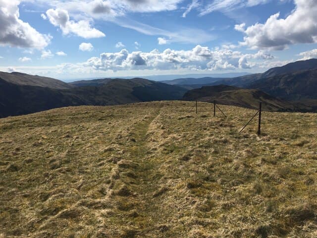
Sgiath a' Chaise (644m) — the wing of the gorge — is a flat-topped outlier in the NN51 square between Lochearnhead and Callander. An iron fence post sits among a few rocks at the high point; the view sweeps from Ben Vorlich south-east across Glen Artney to the lowland edge.
Quick facts
- Height
- 644.2m/ 2114ft
- Prominence
- 303 m
- Distance
- 12 km
- Ascent
- 483 m
- Time
- 3–5 hrs
- Grid ref
- NN583169
- Parking
- NN534151
- Nearest city
- Stirling· 32km
- Dogs
- Dogs on lead required near livestockDog-friendly guide ↗
Height and prominence cross-checked against the Database of British and Irish Hills (CC BY).
No GPX track yet
Walked this route? Share your track to help other walkers.
Standard route
heather moorland 60% · grass slopes 25% · rocky summit 15%
Park at the bend in the road near Glen Buckie south of Strathyre. Take the rough farm track north-east toward Ballimore, then climb pathlessly up the broad south-west spur on grass and bracken. The fence line at the top guides you to the iron post and small rock cluster that mark the summit.
Terrain
Farm track briefly, then mostly pathless grass and bracken on the south-west spur. The upper plateau is firm short turf with a clear fence to follow; the iron post marker is unmistakable on a still day.
In winter
The Strathyre hills get less snow than further north but the grass freezes hard and the open top funnels wind. Sgiath a' Chaise has no avalanche concerns but slips are easy on icy turf — microspikes are usually the right call. Daylight is workable for a short January round.
This hill is in the Southern Highlands SAIS forecast area. Check SAIS forecasts in winter (December–April).
Best time of year
Getting there
- Glasgow1h 14m
- Edinburgh2h 54m
OS maps: OS Landranger 57
Mobile signal: Moderate. EE intermittent on the open plateau; weaker in Glen Buckie.
Current conditions
Daylight Today
- Sunrise
- 04:47
- Sunset
- 21:59
- Civil dawn
- 03:48
- Civil dusk
- 22:57
NOAA Solar Calculator · 13 July 2026
Around Sgiath a' Chaise on the SCOT network
Getting there, basing yourself, and what to do off the hill.
Getting there: Crianlarich station
Crianlarich Munros — Ben More, Stob Binnein, Ben Lui, Cruach Ardrain
22km from the hill
tripscot.co.uk
On TripSCOTBase yourself in Callander
Trossachs gateway — Ben Ledi, Stuc a Chroin, Rob Roy Way
10km from the hill
tripscot.co.uk
On TasteSCOTAfter the hill: Deanston
Doune — converted cotton mill; floral, honeyed Perthshire distillery
21km from the hill
tastescot.co.uk
Sgiath a' Chaise — common questions
- How difficult is Sgiath a' Chaise?
- Sgiath a' Chaise carries a 3/5 (moderately challenging) grade on the OutdoorSCOT scale. Count on about 12km, 483m of ascent and a 3-5 hour day on the standard route. Ground conditions: Farm track briefly, then mostly pathless grass and bracken on the south-west spur.
- How much drop does Sgiath a' Chaise have?
- The drop is 303m: measured from the summit of Sgiath a' Chaise down to the saddle joining it to higher terrain.
- Where's the parking for Sgiath a' Chaise?
- Park at NN534151. Double-check the grid reference on an OS map first; informal laybys here fill early in high season.
- What's the best month to climb Sgiath a' Chaise?
- Aim for March, April, May, June, July, August, September, October, November on Sgiath a' Chaise. In the remaining months treat it as a winter hill — full kit, solid navigation, and a look at the relevant SAIS avalanche forecast before you go.
- Can dogs go up Sgiath a' Chaise?
- Dogs are fine on a lead. The route passes livestock or ground-nesting bird habitat, so keep them close throughout.
- Will I get phone signal on Sgiath a' Chaise?
- Moderate. EE intermittent on the open plateau; weaker in Glen Buckie.
- Is Sgiath a' Chaise safe in winter?
- The Strathyre hills get less snow than further north but the grass freezes hard and the open top funnels wind. Sgiath a' Chaise has no avalanche concerns but slips are easy on icy turf — microspikes are usually the right call. Daylight is workable for a short January round.
Get the OutdoorSCOT weekly
One email a week — new route, hill and bothy guides, seasonal conditions and the odd hard-won lesson. No spam, unsubscribe in one click.