Corbett · Arrochar & Trossachs
Benvane
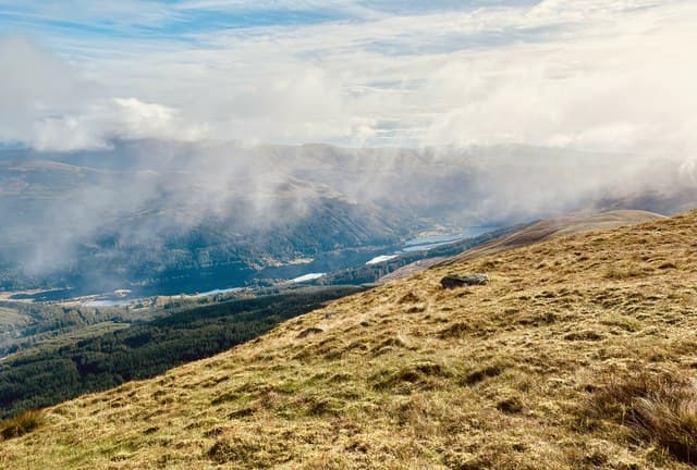
Benvane — "the middle hill", sitting between the better-known Ben Vorlich and Ben Ledi — is a quiet 821m Corbett above Balquhidder Glen at the southern edge of the Trossachs. A small cairn tops the broad grassy ridge with views south to the spread of central Scotland and north to the Crianlarich hills. Despite its location close to the Stirling and Glasgow commuter belt it remains a relatively quiet hill, overshadowed by its more famous neighbours.
Quick facts
- Height
- 821m/ 2694ft
- Prominence
- 215 m
- Distance
- 15 km
- Ascent
- 722 m
- Time
- 5–7 hrs
- Grid ref
- NN535137
- Parking
- NN509207
- Nearest city
- Stirling· 33km
- Dogs
- Dogs on lead required near livestockDog-friendly guide ↗
Height and prominence cross-checked against the Database of British and Irish Hills (CC BY).
No GPX track yet
Walked this route? Share your track to help other walkers.
Standard route
forestry track 30% · open heather 35% · grassy ridge 25% · summit cairn 10%
The standard line starts from the small car park near Ballimore at the head of Balquhidder Glen and follows the forestry track north into Glen Buckie. After roughly 3km, leave the track and climb open heather slopes east onto the broad south-west ridge of Benvane. The ridge gives a steady pull on grass and heather to the summit cairn. Around 15km return with 722m of ascent. Sometimes combined with Ben Vorlich via a longer eastward traverse.
Terrain
The Glen Buckie forestry track is firm. Off the track the hillside is open heather and bracken; pathless and slow on the lower slopes, easing to short grass on the upper ridge. The summit area is broad mossy grass with the cairn at the highest point. No exposure or scrambling on the standard line. The connecting ridge east toward Stob Breac involves significant re-ascent.
In winter
A benign winter hill — gentle gradients, no avalanche slopes, and a forestry approach that gives shelter from the worst of the weather. The Balquhidder road is gritted as far as the church but the side roads can ice. The summit ridge holds drift after westerly storms; navigation in cloud is the main concern.
This hill is in the Southern Highlands SAIS forecast area. Check SAIS forecasts in winter (December–April).
Best time of year
Getting there
- Glasgow1h 9m
- Edinburgh2h 45m
OS maps: OS Landranger 57
Mobile signal: Reasonable signal at Balquhidder; intermittent higher up
Current conditions
Daylight Today
- Sunrise
- 04:47
- Sunset
- 21:59
- Civil dawn
- 03:49
- Civil dusk
- 22:57
NOAA Solar Calculator · 13 July 2026
Pair with
Curated multi-hill combinations from Benvane.
Around Benvane on the SCOT network
Getting there, basing yourself, and what to do off the hill.
Getting there: Crianlarich station
Crianlarich Munros — Ben More, Stob Binnein, Ben Lui, Cruach Ardrain
19km from the hill
tripscot.co.uk
On TripSCOTBase yourself in Callander
Trossachs gateway — Ben Ledi, Stuc a Chroin, Rob Roy Way
11km from the hill
tripscot.co.uk
On TasteSCOTAfter the hill: Deanston
Doune — converted cotton mill; floral, honeyed Perthshire distillery
23km from the hill
tastescot.co.uk
Benvane — common questions
- How hard is Benvane?
- We grade Benvane at 3/5, which puts it in moderately challenging territory. The usual route is around 15km with 722m of climbing; allow 5-7 hours. Ground conditions: The Glen Buckie forestry track is firm.
- How much drop does Benvane have?
- The drop is 215m: measured from the summit of Benvane down to the saddle joining it to higher terrain.
- Where's the parking for Benvane?
- Park at NN509207. Double-check the grid reference on an OS map first; informal laybys here fill early in high season.
- What's the best month to climb Benvane?
- Aim for April, May, June, July, August, September, October on Benvane. In the remaining months treat it as a winter hill — full kit, solid navigation, and a look at the relevant SAIS avalanche forecast before you go.
- Can dogs go up Benvane?
- Dogs are fine on a lead. The route passes livestock or ground-nesting bird habitat, so keep them close throughout.
- Will I get phone signal on Benvane?
- Reasonable signal at Balquhidder; intermittent higher up
- Is Benvane safe in winter?
- A benign winter hill — gentle gradients, no avalanche slopes, and a forestry approach that gives shelter from the worst of the weather. The Balquhidder road is gritted as far as the church but the side roads can ice. The summit ridge holds drift after westerly storms; navigation in cloud is the main concern.
Get the OutdoorSCOT weekly
One email a week — new route, hill and bothy guides, seasonal conditions and the odd hard-won lesson. No spam, unsubscribe in one click.