Corbett · Arrochar & Trossachs
Ben Ledi
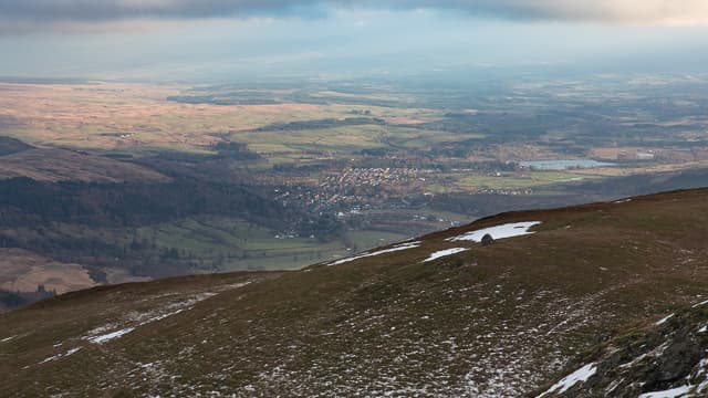
Ben Ledi is the highest hill in the Trossachs and Callander's home mountain — a 879m landmark visible from much of central Scotland and accessible from Glasgow or Edinburgh inside 90 minutes' drive. The name comes from the Gaelic 'Beinn Lèideach', usually translated as 'the hill of the gentle slope'. A Beltane sunrise was traditionally welcomed from the summit, and the tradition still draws a small crowd at first light on the first day of May. The walk is short and the views over Loch Lubnaig and across to the Crianlarich Munros are some of the best for the effort anywhere in central Scotland.
Quick facts
- Height
- 878.6m/ 2883ft
- Prominence
- 528 m
- Distance
- ~10 km
- Ascent
- ~730 m
- Time
- 3–5 hrs
- Grid ref
- NN562098
- Parking
- NN586093
- Nearest city
- Stirling· 29km
- Dogs
- Dogs on lead required near livestockDog-friendly guide ↗
Height and prominence cross-checked against the Database of British and Irish Hills (CC BY).
No GPX track yet
Walked this route? Share your track to help other walkers.
Standard route
forest track 25% · moorland path 35% · stony path 30% · summit plateau 10%
Park at the Stank Glen car park beside the cycleway just south of Strathyre (NN586093). A waymarked path leads west into the Stank Glen, climbing through forestry before breaking out onto open hillside. The rebuilt stone path then climbs steadily onto the broad south-east ridge and on to the summit trig point. Most parties retrace the line; a longer round descends south-west toward Loch Venachar and rejoins the cycleway.
Terrain
Forestry track and stone path on the lower hill — well-maintained by Forestry and Land Scotland, easy underfoot. The upper section is on rebuilt pitched stone, a continuous gradient with no rocky difficulties. The summit plateau is broad and grassy with a trig pillar.
In winter
Ben Ledi holds snow on the upper hill from December to March in cold winters. The pitched path can ice up to a continuous frozen ramp; the upper plateau is wind-scoured. The walk-in through the Stank Glen forest is sheltered and pleasant in any weather, making this a more comfortable winter day than the equivalent exposed Munros nearby.
Kit for this: the winter Munro kit list · which boots take crampons
Best time of year
Getting there
- Glasgow1h 15m
- Edinburgh2h 30m
OS maps: OS Explorer 365
Mobile signal: Reliable EE/Vodafone in the Stank Glen car park; signal weakens through the lower forest but recovers above the treeline; usable on the summit given clear sight of Callander
Current conditions
Daylight Today
- Sunrise
- 07:46
- Sunset
- 18:21
- Civil dawn
- 07:08
- Civil dusk
- 18:58
NOAA Solar Calculator · 14 October 2026
Ben Ledi weather: forecast, wind exposure and winter notes →
Pair with
Curated multi-hill combinations from Ben Ledi.
On a long-distance route
Ben Ledi sits within 5km of these named long-distance walks — useful for trail-pack rest days or section extensions.
Around Ben Ledi on the SCOT network
Getting there, basing yourself, and what to do off the hill.
Getting there: Dunblane station
Stirling-area; Sheriffmuir; gateway north
23km from the hill
tripscot.co.uk
On TripSCOTBase yourself in Callander
Trossachs gateway — Ben Ledi, Stuc a Chroin, Rob Roy Way
7km from the hill
tripscot.co.uk
On TasteSCOTAfter the hill: Deanston
Doune — converted cotton mill; floral, honeyed Perthshire distillery
18km from the hill
tastescot.co.uk
Ben Ledi — common questions
- How difficult is Ben Ledi?
- Ben Ledi carries a 2/5 (moderate) grade on the OutdoorSCOT scale. Count on about 10km, 730m of ascent and a 3-5 hour day on the standard route. Underfoot: Forestry track and stone path on the lower hill — well-maintained by Forestry and Land Scotland, easy underfoot.
- What is Ben Ledi's prominence?
- 528m of prominence. That's the vertical drop from the summit to the col that links Ben Ledi to the next higher ground.
- Where do I park for Ben Ledi?
- Most walkers start from NN586093. Verify the grid reference on an OS map before you set off — space is tight on busy summer weekends.
- When is the best time to climb Ben Ledi?
- March, April, May, June, July, August, September, October, November give the most reliable conditions on Ben Ledi. Beyond that window the high ground turns wintry: carry full mountain kit, be confident navigating, and check the SAIS avalanche forecast for the area.
- Is Ben Ledi dog-friendly?
- Yes, but dogs must be kept on a lead — there is livestock or ground-nesting bird interest on the route.
- Is there mobile signal on Ben Ledi?
- Reliable EE/Vodafone in the Stank Glen car park; signal weakens through the lower forest but recovers above the treeline; usable on the summit given clear sight of Callander
- Is Ben Ledi safe in winter?
- Ben Ledi holds snow on the upper hill from December to March in cold winters. The pitched path can ice up to a continuous frozen ramp; the upper plateau is wind-scoured. The walk-in through the Stank Glen forest is sheltered and pleasant in any weather, making this a more comfortable winter day than the equivalent exposed Munros nearby.
Get the OutdoorSCOT weekly
One email a week — new route, hill and bothy guides, seasonal conditions and the odd hard-won lesson. No spam, unsubscribe in one click.