Graham · Arrochar & Trossachs
Ben Venue
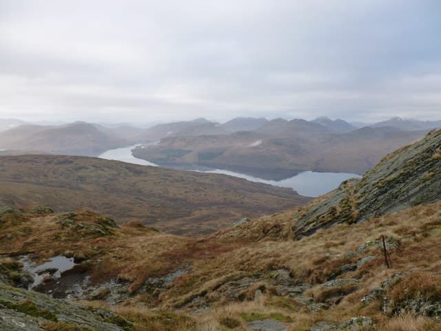
The defining peak of the Trossachs, rising above the south shore of Loch Katrine in twin rocky summits. Walter Scott's hill — name-checked in The Lady of the Lake and visible from every Trossachs viewpoint.
Quick facts
- Height
- 729.5m/ 2393ft
- Prominence
- 545 m
- Distance
- 13 km
- Ascent
- 598 m
- Time
- 3–6 hrs
- Grid ref
- NN474063
- Parking
- NN406085
- Nearest city
- Stirling· 35km
- Dogs
- Dogs on lead required near livestockDog-friendly guide ↗
Height and prominence cross-checked against the Database of British and Irish Hills (CC BY).
No GPX track yet
Walked this route? Share your track to help other walkers.
Standard route
woodland path 25% · moorland path 35% · rocky upper slopes 30% · summit area 10%
Park at Ledard farm on the south side of Loch Achray. Follow the Ledard Burn path north-west up through oak and birch woodland into the upper corrie, then turn west onto the rocky east summit. The slightly higher west top is a short walk on.
Terrain
Excellent path through the lower glen with waterfalls and pools. Higher up, schist outcrops and short grass. The two summits are linked by a stony ridge with one small step.
In winter
Trossachs hills hold snow surprisingly well — the east-facing corries can keep cover into April. Ice on the upper rocky steps catches walkers out. Loch Katrine cruise stops in winter so a return via Ledard is essential.
This hill is in the Southern Highlands SAIS forecast area. Check SAIS forecasts in winter (December–April).
Best time of year
Getting there
- Glasgow1h 1m
- Edinburgh2h 48m
OS maps: OS Landranger 57
Mobile signal: Reception on the lower path; patchy on the summit ridge
Current conditions
Daylight Today
- Sunrise
- 04:54
- Sunset
- 21:54
- Civil dawn
- 03:58
- Civil dusk
- 22:50
NOAA Solar Calculator · 17 July 2026
Pair with
Curated multi-hill combinations from Ben Venue.
Around Ben Venue on the SCOT network
Getting there, basing yourself, and what to do off the hill.
Getting there: Arrochar & Tarbet station
Arrochar Alps — The Cobbler, Beinn Ime, Beinn Narnain, Ben Vane, Ben Vorlich
17km from the hill
tripscot.co.uk
On TripSCOTBase yourself in Callander
Trossachs gateway — Ben Ledi, Stuc a Chroin, Rob Roy Way
16km from the hill
tripscot.co.uk
On TasteSCOTAfter the hill: Deanston
Doune — converted cotton mill; floral, honeyed Perthshire distillery
25km from the hill
tastescot.co.uk
Ben Venue — common questions
- How hard is Ben Venue?
- We grade Ben Venue at 3/5, which puts it in moderately challenging territory. The usual route is around 13km with 598m of climbing; allow 3-6 hours. Ground conditions: Excellent path through the lower glen with waterfalls and pools.
- How much drop does Ben Venue have?
- The drop is 545m: measured from the summit of Ben Venue down to the saddle joining it to higher terrain.
- Where's the parking for Ben Venue?
- Park at NN406085. Double-check the grid reference on an OS map first; informal laybys here fill early in high season.
- What's the best month to climb Ben Venue?
- Aim for April, May, June, July, August, September, October on Ben Venue. In the remaining months treat it as a winter hill — full kit, solid navigation, and a look at the relevant SAIS avalanche forecast before you go.
- Can dogs go up Ben Venue?
- Dogs are fine on a lead. The route passes livestock or ground-nesting bird habitat, so keep them close throughout.
- Will I get phone signal on Ben Venue?
- Reception on the lower path; patchy on the summit ridge
- Is Ben Venue safe in winter?
- Trossachs hills hold snow surprisingly well — the east-facing corries can keep cover into April. Ice on the upper rocky steps catches walkers out. Loch Katrine cruise stops in winter so a return via Ledard is essential.
Get the OutdoorSCOT weekly
One email a week — new route, hill and bothy guides, seasonal conditions and the odd hard-won lesson. No spam, unsubscribe in one click.