Munro · Arrochar & Trossachs
Ben Lomond
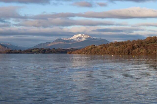
Ben Lomond (974m) is the most southerly of the Munros and far and away the most climbed mountain in Scotland — its iconic profile rising directly above Loch Lomond is visible to walkers across the Central Belt. The summit gives one of the great Highland viewpoints over the long sweep of Loch Lomond and out across the Firth of Clyde. Owned by the National Trust for Scotland; the Tourist Path from Rowardennan is one of the most-trodden mountain routes in the British Isles.
Quick facts
- Height
- 973.7m/ 3195ft
- Prominence
- 820 m
- Distance
- 17 km
- Ascent
- 857 m
- Time
- 5–8 hrs
- Grid ref
- NN367028
- Parking
- NS360985
- Nearest city
- Glasgow· 44km
- Dogs
- Dogs on lead required near livestockDog-friendly guide ↗
Height and prominence cross-checked against the Database of British and Irish Hills (CC BY).
No GPX track yet
Walked this route? Share your track to help other walkers.
Standard route
Tourist Path 55% · Open hillside 25% · Summit ridge 20%
Park at the National Trust car park at Rowardennan on the east shore of Loch Lomond (charge applies). Take the well-built Tourist Path north up the broad south ridge to the summit — restored stone pitching for almost the entire 5km / 970m climb. The Ptarmigan ridge route offers a quieter alternative ascent line on the west side of the hill, often used as the descent for a circular round. The Tourist Path return is 12km with 970m of ascent.
Terrain
The Tourist Path from Rowardennan is one of the best-maintained in Scotland — restored stone pitching along its full length. The Ptarmigan route is rougher but still well-trodden. The summit area is a rocky outcrop with a small stone marker at the apex of a slim rocky crest perched above the steep north corrie. The descent off the summit to the Ptarmigan ridge is steep grass and broken rock.
In winter
A surprisingly serious winter Munro despite the easy summer access. The summit cone holds wind-blown snow and the north-facing corrie develops avalanche-prone slopes after westerly storms. The Tourist Path can become hard névé needing crampons. Ben Lomond is regularly the focus of winter mountain rescue callouts — visitors underestimate the hill in snow. Phone signal good below 700m; fades higher. Gritted access from the A82 to Rowardennan.
This hill is in the Southern Highlands SAIS forecast area. Check SAIS forecasts in winter (December–April).
Best time of year
Getting there
- Glasgow1h 2m
- Edinburgh2h 59m
OS maps: OS Landranger 56
Mobile signal: Excellent signal on the Tourist Path — the most popular Scottish mountain has good 4G coverage from Rowardennan car park to around 700m. Signal fades approaching the summit. Download maps as backup.
Current conditions
Daylight Today
- Sunrise
- 05:05
- Sunset
- 21:45
- Civil dawn
- 04:12
- Civil dusk
- 22:38
NOAA Solar Calculator · 23 July 2026
Pair with
Curated multi-hill combinations from Ben Lomond.
On a long-distance route
Ben Lomond sits within 5km of these named long-distance walks — useful for trail-pack rest days or section extensions.
Around Ben Lomond on the SCOT network
Getting there, basing yourself, and what to do off the hill.
Getting there: Arrochar & Tarbet station
Arrochar Alps — The Cobbler, Beinn Ime, Beinn Narnain, Ben Vane, Ben Vorlich
7km from the hill
tripscot.co.uk
On TripSCOTBase yourself in Luss
West Loch Lomond village — Highland Boundary, Loch Lomond Way
10km from the hill
tripscot.co.uk
On TasteSCOTAfter the hill: Loch Lomond
Alexandria — sprawling distillery on the south end of the loch
22km from the hill
tastescot.co.uk
Ben Lomond — common questions
- How hard is Ben Lomond?
- We grade Ben Lomond at 4/5, which puts it in challenging territory. The usual route is around 17km with 857m of climbing; allow 5-8 hours. Ground conditions: The Tourist Path from Rowardennan is one of the best-maintained in Scotland — restored stone pitching along its full length.
- How much drop does Ben Lomond have?
- The drop is 820m: measured from the summit of Ben Lomond down to the saddle joining it to higher terrain.
- Where's the parking for Ben Lomond?
- Park at NS360985. Double-check the grid reference on an OS map first; informal laybys here fill early in high season.
- What's the best month to climb Ben Lomond?
- Aim for May, June, July, August, September, October on Ben Lomond. In the remaining months treat it as a winter hill — full kit, solid navigation, and a look at the relevant SAIS avalanche forecast before you go.
- Can dogs go up Ben Lomond?
- Dogs are fine on a lead. The route passes livestock or ground-nesting bird habitat, so keep them close throughout.
- Will I get phone signal on Ben Lomond?
- Excellent signal on the Tourist Path — the most popular Scottish mountain has good 4G coverage from Rowardennan car park to around 700m. Signal fades approaching the summit. Download maps as backup.
- Is Ben Lomond safe in winter?
- A surprisingly serious winter Munro despite the easy summer access. The summit cone holds wind-blown snow and the north-facing corrie develops avalanche-prone slopes after westerly storms. The Tourist Path can become hard névé needing crampons. Ben Lomond is regularly the focus of winter mountain rescue callouts — visitors underestimate the hill in snow. Phone signal good below 700m; fades higher. Gritted access from the A82 to Rowardennan.
Get the OutdoorSCOT weekly
One email a week — new route, hill and bothy guides, seasonal conditions and the odd hard-won lesson. No spam, unsubscribe in one click.