Munro · Arrochar & Trossachs
Beinn Ime
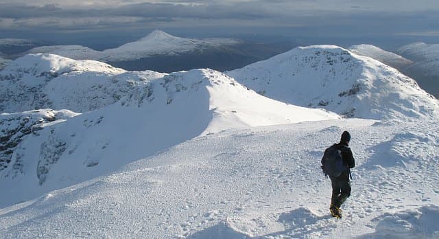
Beinn Ìme (1012m) — "butter hill" — is the highest summit in the Arrochar Alps, the cluster of rocky peaks above Loch Long that includes The Cobbler, Beinn Narnain and Ben Vane. While its neighbours are more famous individually, Beinn Ìme is the high point of the group and gives commanding views over Loch Fyne, Loch Long and the Firth of Clyde. Often climbed alongside Beinn Narnain or The Cobbler from Succoth, or from the Rest and Be Thankful in the north.
Gaelic: “mountain, butter” · Pronunciation: bine ime
Quick facts
- Height
- 1012.2m/ 3321ft
- Prominence
- 713 m
- Distance
- 14 km
- Ascent
- 1330 m
- Time
- 6–8 hrs
- Grid ref
- NN255084
- Parking
- NN294049
- Nearest city
- Oban· 45km
- Dogs
- Dogs on lead required near livestockDog-friendly guide ↗
Height and prominence cross-checked against the Database of British and Irish Hills (CC BY).
No GPX track yet
Walked this route? Share your track to help other walkers.
Standard route
Forest / glen path 35% · Open hillside 40% · Summit area 25%
The classic line is from the Succoth car park at the head of Loch Long. Take the well-built path north onto Beinn Narnain (Munro), then continue north-west down to the Bealach a' Mhaim and climb the steep south-east ridge of Beinn Ìme to the summit. Return the same way or extend over The Cobbler (Corbett) on the way back. The northern approach from the Rest and Be Thankful via the Allt Coiregrogain gives a longer but quieter line. Around 14km with 1330m of ascent for the usual round with Beinn Narnain.
Terrain
The Succoth approach is well-built stone path for the lower section, then becomes rougher on the climb onto Beinn Narnain. The descent to the Bealach a' Mhaim is steep and slippery in the wet. The south-east ridge of Beinn Ìme is a steady climb on grass and broken mica-schist with one short hands-on rocky step. The summit is a broad area with a cairn perched on the remains of an old trig pillar. The Allt Coiregrogain approach from the north is rough boggy moorland.
In winter
A serious Arrochar Alps winter day. The mica-schist faces ice readily and the steep ridge approaches become awkward in snow. The Bealach a' Mhaim collects deep wind-blown snow. The A83 corridor stays gritted; Succoth and Arrochar are reliable winter bases. SAIS Southern Cairngorms is the closest regional indicator. Phone signal at the trailhead is good; absent on the high tops.
This hill is in the Southern Highlands SAIS forecast area. Check SAIS forecasts in winter (December–April).
Best time of year
Getting there
- Glasgow1h 18m
- Edinburgh2h 15m
OS maps: OS Landranger 56
Mobile signal: Good signal at the Rest and Be Thankful car park on the A83. Coverage fades past 700m. The Arrochar Alps are relatively close to the Central Belt.
Current conditions
Daylight Today
- Sunrise
- 05:05
- Sunset
- 21:46
- Civil dawn
- 04:12
- Civil dusk
- 22:39
NOAA Solar Calculator · 23 July 2026
Pair with
Curated multi-hill combinations from Beinn Ime.
Around Beinn Ime on the SCOT network
Getting there, basing yourself, and what to do off the hill.
Beinn Ime — common questions
- What difficulty is Beinn Ime?
- On the OutdoorSCOT scale, Beinn Ime comes in at 4/5 — challenging. Expect roughly 14km and 1330m of ascent on the usual route — 6-8 hours for most parties. Underfoot: The Succoth approach is well-built stone path for the lower section, then becomes rougher on the climb onto Beinn Narnain.
- What is Beinn Ime's prominence?
- 713m of prominence. That's the vertical drop from the summit to the col that links Beinn Ime to the next higher ground.
- Where do I park for Beinn Ime?
- Most walkers start from NN294049. Verify the grid reference on an OS map before you set off — space is tight on busy summer weekends.
- When is the best time to climb Beinn Ime?
- May, June, July, August, September, October give the most reliable conditions on Beinn Ime. Beyond that window the high ground turns wintry: carry full mountain kit, be confident navigating, and check the SAIS avalanche forecast for the area.
- Is Beinn Ime dog-friendly?
- Yes, but dogs must be kept on a lead — there is livestock or ground-nesting bird interest on the route.
- Is there mobile signal on Beinn Ime?
- Good signal at the Rest and Be Thankful car park on the A83. Coverage fades past 700m. The Arrochar Alps are relatively close to the Central Belt.
- Is Beinn Ime safe in winter?
- A serious Arrochar Alps winter day. The mica-schist faces ice readily and the steep ridge approaches become awkward in snow. The Bealach a' Mhaim collects deep wind-blown snow. The A83 corridor stays gritted; Succoth and Arrochar are reliable winter bases. SAIS Southern Cairngorms is the closest regional indicator. Phone signal at the trailhead is good; absent on the high tops.
Get the OutdoorSCOT weekly
One email a week — new route, hill and bothy guides, seasonal conditions and the odd hard-won lesson. No spam, unsubscribe in one click.