Corbett · Arrochar & Trossachs
Stob Coire Creagach (Binnein an Fhidhleir)
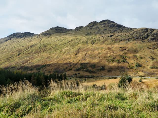
Stob Coire Creagach — commonly called Binnein an Fhidhleir, "the Fiddler's peak" — rises directly above the A83 at the head of Loch Fyne, between Cairndow and the Rest-and-be-Thankful. At 817m the summit is a small rocky top on a long undulating ridge, with 505m of prominence giving it a freestanding feel above its busier Munro neighbours in the Arrochar Alps. The view across Glen Kinglas to Beinn an Lochain and down Loch Fyne to the Cowal hills is one of the finest in the Arrochar area.
Gaelic: “pointed peak, corrie, the” · Pronunciation: stob kor-a creagach (binnein an fhidhleir)
Quick facts
- Height
- 817.8m/ 2683ft
- Prominence
- 505 m
- Distance
- 15 km
- Ascent
- 719 m
- Time
- 4–7 hrs
- Grid ref
- NN230109
- Parking
- NN235094
- Nearest city
- Oban· 42km
- Dogs
- Dogs on lead required near livestockDog-friendly guide ↗
Height and prominence cross-checked against the Database of British and Irish Hills (CC BY).
No GPX track yet
Walked this route? Share your track to help other walkers.
Standard route
steep grass face 35% · undulating ridge 45% · summit rocks 15% · descent 5%
Park in the lay-by on the A83 at the entrance to Glen Kinglas at Butterbridge and follow the open hillside south-east directly up onto the long west ridge of Stob Coire Creagach. The route is pathless but the line is obvious — climb steeply on grass for the first 400m then follow the broad ridge east over several small bumps to the rocky summit. Around 15km return with 719m of ascent. Often combined with neighbouring Beinn an Lochain.
Terrain
No path on the lower hillside — the steep grass and bracken above Butterbridge is direct but slow. The ridge above 600m is firmer with intermittent rock outcrops; navigation along the multiple bumps requires attention in mist. The summit area is a small rocky top with the cairn easy to find. The north drop into Glen Kinglas is steep grass with crag bands; keep south of the ridgeline.
In winter
A typical Arrochar Alps hill — the wet grass slopes ice up quickly when temperatures hover around freezing, and the steep lower face becomes a serious snow slope after westerly storms. The A83 over the Rest-and-be-Thankful is gritted but landslides occasionally close it. The undulating ridge is broad enough for safe navigation; cornices on the north edge above Glen Kinglas.
This hill is in the Southern Highlands SAIS forecast area. Check SAIS forecasts in winter (December–April).
Best time of year
Getting there
- Glasgow1h 23m
- Edinburgh2h 19m
OS maps: OS Landranger 50, OS Landranger 56
Mobile signal: Reasonable signal in Glen Kinglas; sporadic on the upper slopes
Current conditions
Daylight Today
- Sunrise
- 04:55
- Sunset
- 21:56
- Civil dawn
- 03:59
- Civil dusk
- 22:52
NOAA Solar Calculator · 17 July 2026
Got a photo of Stob Coire Creagach (Binnein an Fhidhleir)?
30 seconds, helps other walkers.
Submit a photoAround Stob Coire Creagach (Binnein an Fhidhleir) on the SCOT network
Getting there, basing yourself, and what to do off the hill.
Stob Coire Creagach (Binnein an Fhidhleir) — common questions
- How difficult is Stob Coire Creagach (Binnein an Fhidhleir)?
- Stob Coire Creagach (Binnein an Fhidhleir) carries a 3/5 (moderately challenging) grade on the OutdoorSCOT scale. Count on about 15km, 719m of ascent and a 4-7 hour day on the standard route. Terrain: No path on the lower hillside — the steep grass and bracken above Butterbridge is direct but slow.
- How prominent is Stob Coire Creagach (Binnein an Fhidhleir)?
- Stob Coire Creagach (Binnein an Fhidhleir) has 505m of topographic prominence — the height of its summit above the highest col connecting it to higher ground.
- Where should I park to climb Stob Coire Creagach (Binnein an Fhidhleir)?
- Standard parking is at NN235094. Check the parking grid reference on an OS map before travel; informal laybys can fill on summer weekends.
- When should I climb Stob Coire Creagach (Binnein an Fhidhleir)?
- The standard good-weather months for Stob Coire Creagach (Binnein an Fhidhleir) are April, May, June, July, August, September, October. Outside those months, expect winter conditions on the high ground — full mountain kit, navigation skills, and a check of the SAIS avalanche forecast for the relevant region.
- Can I bring my dog up Stob Coire Creagach (Binnein an Fhidhleir)?
- On a lead only — the route crosses ground with livestock or nesting-bird interest.
- What's mobile reception like on Stob Coire Creagach (Binnein an Fhidhleir)?
- Reasonable signal in Glen Kinglas; sporadic on the upper slopes
- Is Stob Coire Creagach (Binnein an Fhidhleir) safe in winter?
- A typical Arrochar Alps hill — the wet grass slopes ice up quickly when temperatures hover around freezing, and the steep lower face becomes a serious snow slope after westerly storms. The A83 over the Rest-and-be-Thankful is gritted but landslides occasionally close it. The undulating ridge is broad enough for safe navigation; cornices on the north edge above Glen Kinglas.
Get the OutdoorSCOT weekly
One email a week — new route, hill and bothy guides, seasonal conditions and the odd hard-won lesson. No spam, unsubscribe in one click.