Graham · Argyll & Bute
Stob an Eas
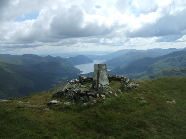
A pointed Graham at the head of Hell's Glen and Glen Croe, looking across to the Cobbler. The summit cone gives a textbook view of the Arrochar Alps from an angle most walkers never see.
Quick facts
- Height
- 732m/ 2402ft
- Prominence
- 248 m
- Distance
- 14 km
- Ascent
- 600 m
- Time
- 4–6 hrs
- Grid ref
- NN185074
- Parking
- NN209084
- Nearest city
- Oban· 40km
- Dogs
- Dogs on lead required near livestockDog-friendly guide ↗
Height and prominence cross-checked against the Database of British and Irish Hills (CC BY).
No GPX track yet
Walked this route? Share your track to help other walkers.
Standard route
glen track 25% · heather hillside 45% · grassy upper slopes 20% · summit area 10%
Park at Lochgoilhead and walk up the minor road through Hell's Glen. Take the stalkers' path north-west into Coire Lochain, then climb the south-east ridge directly to the cone. Return by the same route or extend west to A' Chrois.
Terrain
Tarmac and forest tracks for the first kilometre, then a clear stalkers' path. The summit cone is steep heather with small outcrops — easy hands-on work near the top.
In winter
The eastern corrie holds snow well and the summit cone gets blasted by westerlies straight off Loch Long. A reasonable winter outing in good conditions but the cone in poor visibility is unforgiving.
Best time of year
Getting there
- Glasgow1h 23m
- Edinburgh2h 23m
OS maps: OS Landranger 56
Mobile signal: Reception at Lochgoilhead; gone above the treeline
Current conditions
Daylight Today
- Sunrise
- 04:50
- Sunset
- 22:01
- Civil dawn
- 03:52
- Civil dusk
- 22:59
NOAA Solar Calculator · 13 July 2026
Around Stob an Eas on the SCOT network
Getting there, basing yourself, and what to do off the hill.
Stob an Eas — common questions
- How difficult is Stob an Eas?
- Stob an Eas carries a 3/5 (moderately challenging) grade on the OutdoorSCOT scale. Count on about 14km, 600m of ascent and a 4-6 hour day on the standard route. Ground conditions: Tarmac and forest tracks for the first kilometre, then a clear stalkers' path.
- How much drop does Stob an Eas have?
- The drop is 248m: measured from the summit of Stob an Eas down to the saddle joining it to higher terrain.
- Where's the parking for Stob an Eas?
- Park at NN209084. Double-check the grid reference on an OS map first; informal laybys here fill early in high season.
- What's the best month to climb Stob an Eas?
- Aim for April, May, June, July, August, September, October on Stob an Eas. In the remaining months treat it as a winter hill — full kit, solid navigation, and a look at the relevant SAIS avalanche forecast before you go.
- Can dogs go up Stob an Eas?
- Dogs are fine on a lead. The route passes livestock or ground-nesting bird habitat, so keep them close throughout.
- Will I get phone signal on Stob an Eas?
- Reception at Lochgoilhead; gone above the treeline
- Is Stob an Eas safe in winter?
- The eastern corrie holds snow well and the summit cone gets blasted by westerlies straight off Loch Long. A reasonable winter outing in good conditions but the cone in poor visibility is unforgiving.
Get the OutdoorSCOT weekly
One email a week — new route, hill and bothy guides, seasonal conditions and the odd hard-won lesson. No spam, unsubscribe in one click.