Corbett · Argyll & Bute
Ben Donich
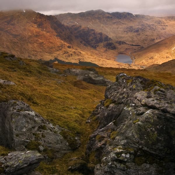
Ben Donich is the broad-shouldered Corbett at the head of Loch Goil — together with neighbouring The Brack it forms the natural pair of walks from the village of Lochgoilhead. The mountain has a friendlier feel than its Arrochar Alps neighbours across Glen Croe: the slopes are gentler, the path is good, the summit is broad and easy. The walking can be done as a half-day from the Rest and be Thankful, or extended into a 6–7 hour double with The Brack. Views from the top take in Loch Goil, the Firth of Clyde and on a clear day Arran's silhouette.
Quick facts
- Height
- 846.5m/ 2777ft
- Prominence
- 557 m
- Distance
- 10 km
- Ascent
- 770 m
- Time
- 3–5 hrs
- Grid ref
- NN218043
- Parking
- NN229069
- Nearest city
- Oban· 44km
- Dogs
- Dogs on lead required near livestockDog-friendly guide ↗
Height and prominence cross-checked against the Database of British and Irish Hills (CC BY).
No GPX track yet
Walked this route? Share your track to help other walkers.
Standard route
village path 20% · forest track 20% · heather hillside 40% · summit rocks 20%
The classic line starts from the layby on the A83 at the Rest and Be Thankful. Cross the road and follow a Forestry and Land Scotland path north-east, climbing through plantation and breaking out onto open hill. From there a steady pull leads onto Ben Donich's broad south-west ridge and follows it to the trig point at the summit. The straightforward descent retraces the ascent; a longer-day option drops east into Glen Donich and picks up the minor road back to the car park. Allow 4–5 hours.
Terrain
Good forestry path on the lower slopes — well-maintained as part of the FLS estate. Above the trees the going is heather and grass with a few small rocky steps. The ridge is broad and friendly; the summit area has a small fenced cairn around the trig pillar. In wet conditions the lower paths can be muddy where forestry vehicles have used them.
In winter
Lower-altitude maritime Corbett — snow is intermittent and rarely deep. When it does fall, the broad ridge is sheltered enough that conditions are usually benign for walkers with basic winter kit. The descent through plantation can be the most awkward part in iced conditions.
Best time of year
Getting there
- Glasgow1h 17m
- Edinburgh2h 18m
OS maps: OS Landranger 56
Mobile signal: EE/Vodafone signal usable at the Rest and Be Thankful car park; patchy on the summit
Current conditions
Daylight Today
- Sunrise
- 04:50
- Sunset
- 22:01
- Civil dawn
- 03:52
- Civil dusk
- 22:58
NOAA Solar Calculator · 13 July 2026
Pair with
Curated multi-hill combinations from Ben Donich.
Around Ben Donich on the SCOT network
Getting there, basing yourself, and what to do off the hill.
Getting there: Arrochar & Tarbet station
Arrochar Alps — The Cobbler, Beinn Ime, Beinn Narnain, Ben Vane, Ben Vorlich
8km from the hill
tripscot.co.uk
On TripSCOTBase yourself in Luss
West Loch Lomond village — Highland Boundary, Loch Lomond Way
18km from the hill
tripscot.co.uk
On TasteSCOTAfter the hill: Loch Lomond
Alexandria — sprawling distillery on the south end of the loch
29km from the hill
tastescot.co.uk
Ben Donich — common questions
- How hard is Ben Donich?
- We grade Ben Donich at 2/5, which puts it in moderate territory. The usual route is around 10km with 770m of climbing; allow 3-5 hours. Underfoot: Good forestry path on the lower slopes — well-maintained as part of the FLS estate.
- What is Ben Donich's prominence?
- 557m of prominence. That's the vertical drop from the summit to the col that links Ben Donich to the next higher ground.
- Where do I park for Ben Donich?
- Most walkers start from NN229069. Verify the grid reference on an OS map before you set off — space is tight on busy summer weekends.
- When is the best time to climb Ben Donich?
- March, April, May, June, July, August, September, October, November give the most reliable conditions on Ben Donich. Beyond that window the high ground turns wintry: carry full mountain kit, be confident navigating, and check the SAIS avalanche forecast for the area.
- Is Ben Donich dog-friendly?
- Yes, but dogs must be kept on a lead — there is livestock or ground-nesting bird interest on the route.
- Is there mobile signal on Ben Donich?
- EE/Vodafone signal usable at the Rest and Be Thankful car park; patchy on the summit
- Is Ben Donich safe in winter?
- Lower-altitude maritime Corbett — snow is intermittent and rarely deep. When it does fall, the broad ridge is sheltered enough that conditions are usually benign for walkers with basic winter kit. The descent through plantation can be the most awkward part in iced conditions.
Get the OutdoorSCOT weekly
One email a week — new route, hill and bothy guides, seasonal conditions and the odd hard-won lesson. No spam, unsubscribe in one click.