Corbett · Argyll & Bute
The Brack
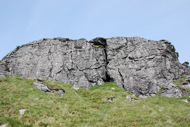
The Brack ranks as one of the dark, broad-shouldered Corbetts of the Ardgartan peninsula in the Arrochar Alps. Together with neighbouring Ben Donich it forms a paired walk from Lochgoilhead and has a quieter feel than the better-known Arrochar Munros across Glen Croe. The summit is a rough plateau of grass and rock with views down Loch Goil to the Firth of Clyde — when it isn't sitting in cloud, which it often is. The original 'East Face' winter climbing crag of Scottish mountaineering history is on the Brack's north-east face.
Quick facts
- Height
- 787.5m/ 2584ft
- Prominence
- 403 m
- Distance
- 12 km
- Ascent
- 800 m
- Time
- 3–5 hrs
- Grid ref
- NN245030
- Parking
- NN272039
- Nearest city
- Oban· 47km
- Dogs
- Dogs on lead required near livestockDog-friendly guide ↗
Height and prominence cross-checked against the Database of British and Irish Hills (CC BY).
No GPX track yet
Walked this route? Share your track to help other walkers.
Standard route
forest track 20% · steep heather 40% · rocky upper section 30% · summit area 10%
Start at the Coilessan Forest gate near Ardgartan on the A83. A forestry track climbs east-south-east through plantation for around 3km. Leave the track where it bends north and head east up steep grass and rough heather onto the broad south ridge. Follow the ridge to the trig point at the summit. Return by the same route, or include Ben Donich by descending east into the Lochgoil road and climbing back. Allow 5–6 hours for The Brack alone.
Terrain
Lower slopes are commercial Sitka plantation crossed by forestry tracks. Above the forest the going is steep, tussocky and often wet. The summit plateau is broad with low rocky outcrops; cornices form on the north edge in winter.
In winter
Despite the unimposing height The Brack carries serious winter conditions on its north-east face — a historic ground for early Scottish ice climbers. For walkers, the ascent route stays clear of the steep ground; care is needed on the broad summit plateau where the cliff edge is not always visible under snow.
Best time of year
Getting there
- Glasgow1h 13m
- Edinburgh2h 14m
OS maps: OS Landranger 56
Mobile signal: Poor signal in Lochgoil area; brief coverage near the village
Current conditions
Daylight Today
- Sunrise
- 04:50
- Sunset
- 22:00
- Civil dawn
- 03:52
- Civil dusk
- 22:58
NOAA Solar Calculator · 13 July 2026
Pair with
Curated multi-hill combinations from The Brack.
On a long-distance route
The Brack sits within 5km of these named long-distance walks — useful for trail-pack rest days or section extensions.
Around The Brack on the SCOT network
Getting there, basing yourself, and what to do off the hill.
Getting there: Arrochar & Tarbet station
Arrochar Alps — The Cobbler, Beinn Ime, Beinn Narnain, Ben Vane, Ben Vorlich
6km from the hill
tripscot.co.uk
On TripSCOTBase yourself in Luss
West Loch Lomond village — Highland Boundary, Loch Lomond Way
15km from the hill
tripscot.co.uk
On TasteSCOTAfter the hill: Loch Lomond
Alexandria — sprawling distillery on the south end of the loch
27km from the hill
tastescot.co.uk
The Brack — common questions
- How hard is The Brack?
- We grade The Brack at 2/5, which puts it in moderate territory. The usual route is around 12km with 800m of climbing; allow 3-5 hours. Ground conditions: Lower slopes are commercial Sitka plantation crossed by forestry tracks.
- How much drop does The Brack have?
- The drop is 403m: measured from the summit of The Brack down to the saddle joining it to higher terrain.
- Where's the parking for The Brack?
- Park at NN272039. Double-check the grid reference on an OS map first; informal laybys here fill early in high season.
- What's the best month to climb The Brack?
- Aim for April, May, June, July, August, September, October on The Brack. In the remaining months treat it as a winter hill — full kit, solid navigation, and a look at the relevant SAIS avalanche forecast before you go.
- Can dogs go up The Brack?
- Dogs are fine on a lead. The route passes livestock or ground-nesting bird habitat, so keep them close throughout.
- Will I get phone signal on The Brack?
- Poor signal in Lochgoil area; brief coverage near the village
- Is The Brack safe in winter?
- Despite the unimposing height The Brack carries serious winter conditions on its north-east face — a historic ground for early Scottish ice climbers. For walkers, the ascent route stays clear of the steep ground; care is needed on the broad summit plateau where the cliff edge is not always visible under snow.
Get the OutdoorSCOT weekly
One email a week — new route, hill and bothy guides, seasonal conditions and the odd hard-won lesson. No spam, unsubscribe in one click.