Corbett · Arrochar & Trossachs
Beinn Luibhean
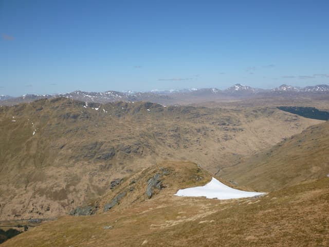
Beinn Luibhean is the small, sharply-pointed Corbett tucked behind Beinn Ime in the Arrochar Alps, almost directly above the famous Rest-and-be-Thankful viewpoint on the A83. Its 859m summit gets little traffic compared to the busy Cobbler or Ben Vorlich a short distance away, partly because the steep grass south face is brutally direct. Those who do make the trip are rewarded with one of the cleanest views in the southern Highlands: straight along Loch Long to the Clyde and across the entire spread of Cowal.
Quick facts
- Height
- 859.7m/ 2821ft
- Prominence
- 181 m
- Distance
- 15 km
- Ascent
- 756 m
- Time
- 5–7 hrs
- Grid ref
- NN242079
- Parking
- NN229074
- Nearest city
- Oban· 44km
- Dogs
- Dogs on lead required near livestockDog-friendly guide ↗
Height and prominence cross-checked against the Database of British and Irish Hills (CC BY).
No GPX track yet
Walked this route? Share your track to help other walkers.
Standard route
roadside grass 15% · steep grass 50% · rocky upper section 25% · summit area 10%
Park at the Rest-and-be-Thankful and walk a short distance west along the A83 to where the open hillside drops to the road. Cross the burn and climb the relentless south-east face direct — there is no path, just steep grass with rocky steps for around 700m of unbroken ascent in 2km. The summit ridge is short and rocky, with one slightly airy section before the top. Around 15km total with 756m of ascent if combined with neighbouring Beinn Ime; 6km return for Luibhean alone.
Terrain
The south face is unrelentingly steep grass and bracken with no path — knees and ankles take a beating on descent. Above 700m the slope eases and the ridge becomes rocky with intermittent outcrops. The connecting ridge to Beinn Ime drops to a wet bealach then climbs again on grass and rock; the col is exposed to westerly wind. Mica schist underfoot is glassy when wet.
In winter
The Arrochar Alps catch huge amounts of west coast precipitation and Beinn Luibhean is no exception — its grass slopes ice up to a glaze far quicker than the more sheltered hills inland. The steep south face becomes a serious avalanche slope after fresh westerly snow loading and the descent line should be reconsidered if conditions look poor. Crampons more useful here than the height suggests.
This hill is in the Southern Highlands SAIS forecast area. Check SAIS forecasts in winter (December–April).
Best time of year
Getting there
- Glasgow1h 18m
- Edinburgh2h 16m
OS maps: OS Landranger 56
Mobile signal: Poor signal near the Rest-and-be-Thankful; no coverage on the summit
Current conditions
Daylight Today
- Sunrise
- 04:55
- Sunset
- 21:56
- Civil dawn
- 04:00
- Civil dusk
- 22:51
NOAA Solar Calculator · 17 July 2026
Pair with
Curated multi-hill combinations from Beinn Luibhean.
Around Beinn Luibhean on the SCOT network
Getting there, basing yourself, and what to do off the hill.
Beinn Luibhean — common questions
- How hard is Beinn Luibhean?
- We grade Beinn Luibhean at 3/5, which puts it in moderately challenging territory. The usual route is around 15km with 756m of climbing; allow 5-7 hours. Underfoot: The south face is unrelentingly steep grass and bracken with no path — knees and ankles take a beating on descent.
- What is Beinn Luibhean's prominence?
- 181m of prominence. That's the vertical drop from the summit to the col that links Beinn Luibhean to the next higher ground.
- Where do I park for Beinn Luibhean?
- Most walkers start from NN229074. Verify the grid reference on an OS map before you set off — space is tight on busy summer weekends.
- When is the best time to climb Beinn Luibhean?
- May, June, July, August, September, October give the most reliable conditions on Beinn Luibhean. Beyond that window the high ground turns wintry: carry full mountain kit, be confident navigating, and check the SAIS avalanche forecast for the area.
- Is Beinn Luibhean dog-friendly?
- Yes, but dogs must be kept on a lead — there is livestock or ground-nesting bird interest on the route.
- Is there mobile signal on Beinn Luibhean?
- Poor signal near the Rest-and-be-Thankful; no coverage on the summit
- Is Beinn Luibhean safe in winter?
- The Arrochar Alps catch huge amounts of west coast precipitation and Beinn Luibhean is no exception — its grass slopes ice up to a glaze far quicker than the more sheltered hills inland. The steep south face becomes a serious avalanche slope after fresh westerly snow loading and the descent line should be reconsidered if conditions look poor. Crampons more useful here than the height suggests.
Get the OutdoorSCOT weekly
One email a week — new route, hill and bothy guides, seasonal conditions and the odd hard-won lesson. No spam, unsubscribe in one click.