Corbett · Arrochar & Trossachs
Beinn an Lochain
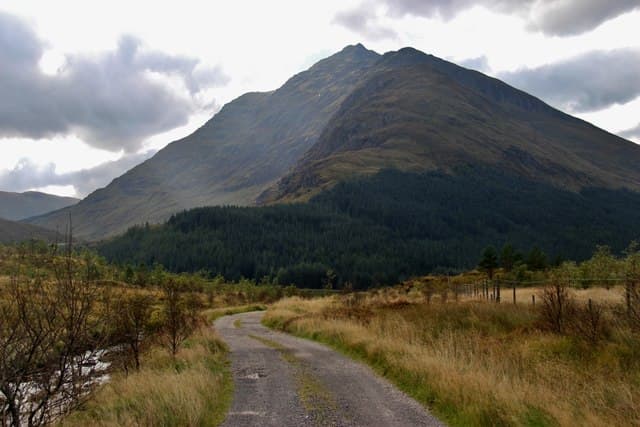
Beinn an Lochain is the steep-sided 901m Corbett rising directly above the Rest and Be Thankful pass at the head of Glen Croe — visible from any northbound driver on the A83 between Tarbet and Inveraray. The mountain has been demoted from and reinstated as a Munro twice in the 20th century as survey techniques improved; the current measurement leaves it just below the threshold. Whatever its formal status, it offers some of the most efficient summit views in the Arrochar Alps — 730m of ascent in less than 3km, with a near-360° panorama from a small rocky top.
Gaelic: “mountain, the, small loch” · Pronunciation: bine an loch-een
Quick facts
- Height
- 901.7m/ 2958ft
- Prominence
- 640 m
- Distance
- 6 km
- Ascent
- 730 m
- Time
- 2–4 hrs
- Grid ref
- NN218079
- Parking
- NN229076
- Nearest city
- Oban· 42km
- Dogs
- Dogs on lead required near livestockDog-friendly guide ↗
Height and prominence cross-checked against the Database of British and Irish Hills (CC BY).
No GPX track yet
Walked this route? Share your track to help other walkers.
Standard route
roadside grass 10% · steep grass 50% · rocky ridge 30% · heather moorland 10%
Park at the small layby on the A83 at the south end of Loch Restil (NN229076), where the road starts climbing toward the Rest and Be Thankful proper. Cross the road and pick up a faint path that climbs steeply through grass onto the south-east ridge of Beinn an Lochain. The route is short and unrelenting: about 730m of climb in 3km. The summit is a small rocky top with a cairn. Descent retraces the line. Allow 3.5–4.5 hours.
Terrain
Steep, eroded grass for the lower 600m of ascent — slippery in wet conditions. The upper ridge is firm rock with mild exposure on the south face. The summit area is small and rocky; in cloud, choosing the right line off the south-east shoulder needs care because the broad upper hill has subtle false tops.
In winter
In winter the steep grass-and-rock ascent becomes a serious snow climb requiring axe and crampons. The summit ridge cornices on the east side and the descent line in poor visibility is committing. A short but serious winter hill — the gradient alone makes it more demanding than the metrics suggest.
This hill is in the Southern Highlands SAIS forecast area. Check SAIS forecasts in winter (December–April).
Best time of year
Getting there
- Glasgow1h 10m
- Edinburgh2h 55m
OS maps: OS Explorer 364, OS Landranger 56
Mobile signal: Patchy signal from the Rest-and-be-Thankful; summit typically has no coverage
Current conditions
Daylight Today
- Sunrise
- 04:56
- Sunset
- 21:56
- Civil dawn
- 04:00
- Civil dusk
- 22:52
NOAA Solar Calculator · 17 July 2026
Pair with
Curated multi-hill combinations from Beinn an Lochain.
Around Beinn an Lochain on the SCOT network
Getting there, basing yourself, and what to do off the hill.
Beinn an Lochain — common questions
- Is Beinn an Lochain a hard climb?
- Beinn an Lochain is rated 3/5 (moderately challenging) on the OutdoorSCOT scale. The standard route covers about 6km with 730m of ascent and takes most walkers 2-4 hours. Underfoot: Steep, eroded grass for the lower 600m of ascent — slippery in wet conditions.
- What is Beinn an Lochain's prominence?
- 640m of prominence. That's the vertical drop from the summit to the col that links Beinn an Lochain to the next higher ground.
- Where do I park for Beinn an Lochain?
- Most walkers start from NN229076. Verify the grid reference on an OS map before you set off — space is tight on busy summer weekends.
- When is the best time to climb Beinn an Lochain?
- May, June, July, August, September, October give the most reliable conditions on Beinn an Lochain. Beyond that window the high ground turns wintry: carry full mountain kit, be confident navigating, and check the SAIS avalanche forecast for the area.
- Is Beinn an Lochain dog-friendly?
- Yes, but dogs must be kept on a lead — there is livestock or ground-nesting bird interest on the route.
- Is there mobile signal on Beinn an Lochain?
- Patchy signal from the Rest-and-be-Thankful; summit typically has no coverage
- Is Beinn an Lochain safe in winter?
- In winter the steep grass-and-rock ascent becomes a serious snow climb requiring axe and crampons. The summit ridge cornices on the east side and the descent line in poor visibility is committing. A short but serious winter hill — the gradient alone makes it more demanding than the metrics suggest.
Get the OutdoorSCOT weekly
One email a week — new route, hill and bothy guides, seasonal conditions and the odd hard-won lesson. No spam, unsubscribe in one click.