Graham · Argyll & Bute
Cruach nam Mult
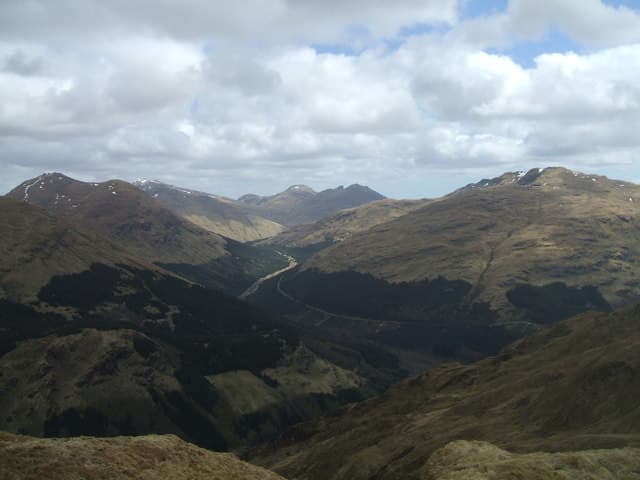
Cruach nam Mult (611m), the wether-sheep mountain, sits above Glen Croe in the NN10 square, on the north flank of the Arrochar pass to Inveraray. The unmarked summit is a small grass knoll at the end of a long undulating ridge between Cruach Tairbeirt and the road over the Rest and Be Thankful. The view encompasses the Cobbler, Beinn Ime and the head of Loch Long.
Quick facts
- Height
- 611.2m/ 2005ft
- Prominence
- 282 m
- Distance
- 12 km
- Ascent
- 458 m
- Time
- 3–5 hrs
- Grid ref
- NN168056
- Parking
- NN159049
- Nearest city
- Oban· 39km
- Dogs
- Dogs on lead required near livestockDog-friendly guide ↗
Height and prominence cross-checked against the Database of British and Irish Hills (CC BY).
No GPX track yet
Walked this route? Share your track to help other walkers.
Standard route
heather and bog 65% · grass slopes 25% · rocky summit 10%
From parking at NN159049 in the lower glen, follow the forest road that climbs steadily into the side of Glen Croe before peeling off onto open hillside on the southern slope. The crest is reached after a steady pull through clearfell and rough grass; the summit knoll lies near the eastern end of the ridge. About four and a half hours round, returning by the same line.
Terrain
Plantation tracks and clearfell ground at low altitude give way to short heather and bilberry above the deer fence. The summit ridge is broad and grassy with no significant outcrop. Burns drain steeply south into Glen Croe — care needed in cloud.
In winter
The Arrochar hills sit in a notoriously wet maritime climate, so deep snow is rare on Cruach nam Mult but freezing rain and verglas are common on the clearfell tracks. The Rest and Be Thankful road below is occasionally shut by landslip — keep an eye on conditions before setting out.
Best time of year
Getting there
- Glasgow1h 23m
- Edinburgh2h 24m
OS maps: OS Landranger 56
Mobile signal: Minimal. Remote Argyll; just fragments of signal.
Current conditions
Daylight Today
- Sunrise
- 04:50
- Sunset
- 22:01
- Civil dawn
- 03:52
- Civil dusk
- 22:59
NOAA Solar Calculator · 13 July 2026
Around Cruach nam Mult on the SCOT network
Getting there, basing yourself, and what to do off the hill.
Cruach nam Mult — common questions
- How difficult is Cruach nam Mult?
- Cruach nam Mult carries a 3/5 (moderately challenging) grade on the OutdoorSCOT scale. Count on about 12km, 458m of ascent and a 3-5 hour day on the standard route. Underfoot: Plantation tracks and clearfell ground at low altitude give way to short heather and bilberry above the deer fence.
- What is Cruach nam Mult's prominence?
- 282m of prominence. That's the vertical drop from the summit to the col that links Cruach nam Mult to the next higher ground.
- Where do I park for Cruach nam Mult?
- Most walkers start from NN159049. Verify the grid reference on an OS map before you set off — space is tight on busy summer weekends.
- When is the best time to climb Cruach nam Mult?
- March, April, May, June, July, August, September, October, November give the most reliable conditions on Cruach nam Mult. Beyond that window the high ground turns wintry: carry full mountain kit, be confident navigating, and check the SAIS avalanche forecast for the area.
- Is Cruach nam Mult dog-friendly?
- Yes, but dogs must be kept on a lead — there is livestock or ground-nesting bird interest on the route.
- Is there mobile signal on Cruach nam Mult?
- Minimal. Remote Argyll; just fragments of signal.
- Is Cruach nam Mult safe in winter?
- The Arrochar hills sit in a notoriously wet maritime climate, so deep snow is rare on Cruach nam Mult but freezing rain and verglas are common on the clearfell tracks. The Rest and Be Thankful road below is occasionally shut by landslip — keep an eye on conditions before setting out.
Get the OutdoorSCOT weekly
One email a week — new route, hill and bothy guides, seasonal conditions and the odd hard-won lesson. No spam, unsubscribe in one click.