Corbett · Argyll & Bute
Beinn Bheula
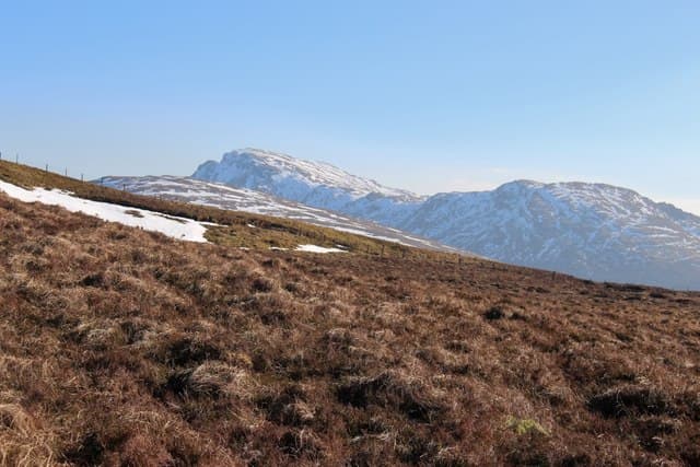
Beinn Bheula is the highest hill in the Cowal peninsula and the only Corbett south of the Clyde-to-Loch Fyne line. The mountain rises above Lochgoilhead at the head of Loch Goil and is reached on quiet single-track roads from Glasgow in around 90 minutes. The summit is a craggy plateau with a trig pillar in a small stone shelter, and the view takes in Bute, Arran and the long line of the Cowal hills running south to Kintyre. A modest day on the metrics, but the road in counts among the most scenic short drives in Scotland.
Quick facts
- Height
- 779m/ 2556ft
- Prominence
- 557 m
- Distance
- 13 km
- Ascent
- 800 m
- Time
- 3–5 hrs
- Grid ref
- NS154983
- Parking
- NN187003
- Nearest city
- Oban· 43km
- Dogs
- Dogs on lead required near livestockDog-friendly guide ↗
Height and prominence cross-checked against the Database of British and Irish Hills (CC BY).
No GPX track yet
Walked this route? Share your track to help other walkers.
Standard route
moorland track 20% · heather hillside 45% · grassy ridge 25% · summit area 10%
The usual route starts from Lettermay car park near Lochgoilhead. A forestry track climbs west-north-west through Lettermay Forest, eventually breaking out onto open hillside. Cross the moorland to the foot of the south-east ridge of Beinn Bheula, then climb steadily over heather and rock outcrops to the summit. Descent simply reverses the route. Allow 5–6 hours.
Terrain
Forestry track for the first 4km, then open heather hillside with several small rocky outcrops to weave around. The upper slopes have small crags with a sense of more rugged terrain than the height suggests. The summit plateau is rocky and well-marked. Wet conditions make the lower forest path muddy.
In winter
Maritime southern Highland conditions — snow rarely deep, but freeze-thaw cycles produce treacherous ice on the forest tracks. The upper rocky outcrops can hold verglas longer than the gradient suggests. A pleasant winter walk in firm conditions, an awkward one in thaw.
Best time of year
Getting there
- Glasgow1h 18m
- Edinburgh2h 24m
OS maps: OS Landranger 56
Mobile signal: Patchy EE/Vodafone in Lochgoilhead village; intermittent higher up with line-of-sight south to the Firth of Clyde
Current conditions
Daylight Today
- Sunrise
- 04:51
- Sunset
- 22:01
- Civil dawn
- 03:53
- Civil dusk
- 22:58
NOAA Solar Calculator · 13 July 2026
Pair with
Curated multi-hill combinations from Beinn Bheula.
Around Beinn Bheula on the SCOT network
Getting there, basing yourself, and what to do off the hill.
Getting there: Arrochar & Tarbet station
Arrochar Alps — The Cobbler, Beinn Ime, Beinn Narnain, Ben Vane, Ben Vorlich
16km from the hill
tripscot.co.uk
On TripSCOTBase yourself in Luss
West Loch Lomond village — Highland Boundary, Loch Lomond Way
21km from the hill
tripscot.co.uk
On TasteSCOTAfter the hill: Loch Lomond
Alexandria — sprawling distillery on the south end of the loch
29km from the hill
tastescot.co.uk
Beinn Bheula — common questions
- What difficulty is Beinn Bheula?
- On the OutdoorSCOT scale, Beinn Bheula comes in at 2/5 — moderate. Expect roughly 13km and 800m of ascent on the usual route — 3-5 hours for most parties. Terrain: Forestry track for the first 4km, then open heather hillside with several small rocky outcrops to weave around.
- How prominent is Beinn Bheula?
- Beinn Bheula has 557m of topographic prominence — the height of its summit above the highest col connecting it to higher ground.
- Where should I park to climb Beinn Bheula?
- Standard parking is at NN187003. Check the parking grid reference on an OS map before travel; informal laybys can fill on summer weekends.
- When should I climb Beinn Bheula?
- The standard good-weather months for Beinn Bheula are March, April, May, June, July, August, September, October, November. Outside those months, expect winter conditions on the high ground — full mountain kit, navigation skills, and a check of the SAIS avalanche forecast for the relevant region.
- Can I bring my dog up Beinn Bheula?
- On a lead only — the route crosses ground with livestock or nesting-bird interest.
- What's mobile reception like on Beinn Bheula?
- Patchy EE/Vodafone in Lochgoilhead village; intermittent higher up with line-of-sight south to the Firth of Clyde
- Is Beinn Bheula safe in winter?
- Maritime southern Highland conditions — snow rarely deep, but freeze-thaw cycles produce treacherous ice on the forest tracks. The upper rocky outcrops can hold verglas longer than the gradient suggests. A pleasant winter walk in firm conditions, an awkward one in thaw.
Get the OutdoorSCOT weekly
One email a week — new route, hill and bothy guides, seasonal conditions and the odd hard-won lesson. No spam, unsubscribe in one click.