Graham · Argyll & Bute
Beinn Lochain
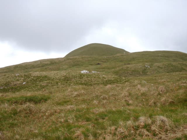
Beinn Lochain (702m) rises from the head of Loch Goil in Argyll's Cowal peninsula, its NN16 summit a steep cone wedged between Lochgoilhead and Hell's Glen. The name simply means hill of the small loch, a reference to the lochan tucked into its eastern corrie. The view stretches across the Arrochar Alps to Beinn Bheula and out over the Clyde sea-lochs toward Bute.
Gaelic: “mountain, small loch” · Pronunciation: bine loch-een
Quick facts
- Height
- 702.9m/ 2306ft
- Prominence
- 375 m
- Distance
- 13 km
- Ascent
- 576 m
- Time
- 3–6 hrs
- Grid ref
- NN160006
- Parking
- NN149000
- Nearest city
- Oban· 42km
- Dogs
- Dogs on lead required near livestockDog-friendly guide ↗
Height and prominence cross-checked against the Database of British and Irish Hills (CC BY).
No GPX track yet
Walked this route? Share your track to help other walkers.
Standard route
grass slopes 50% · heather and bracken 35% · rocky summit 15%
Park at the road junction north of Lochgoilhead and follow the forestry road up the Donich Water for around 2km. Strike up the south-west shoulder on a faint quad track that gains height steadily through tussock and rock band. The final 200m to the cairn is on cropped grass with one short scrambly step on schist.
Terrain
Forest road, then bog at the treeline, before the angle steepens onto cropped grass and broken schist. The south-west ridge is straightforward but a single rock band around 600m needs a careful step in the wet. The summit area is small and exposed to westerly wind.
In winter
Cowal winters are wet rather than cold, but a hard frost glazes the schist slabs and the upper ridge then becomes serious. Snow rarely lies deep on Beinn Lochain but verglas on the NN16 crags is the real hazard. SAIS does not cover Cowal — judge conditions on what the Arrochar Alps to the north have received.
Best time of year
Getting there
- Glasgow1h 20m
- Edinburgh2h 24m
OS maps: OS Landranger 56
Mobile signal: Moderate. EE connects on higher ground; Vodafone patchy. Good signal toward Loch Fyne.
Current conditions
Daylight Today
- Sunrise
- 04:50
- Sunset
- 22:01
- Civil dawn
- 03:53
- Civil dusk
- 22:58
NOAA Solar Calculator · 13 July 2026
Around Beinn Lochain on the SCOT network
Getting there, basing yourself, and what to do off the hill.
Beinn Lochain — common questions
- How hard is Beinn Lochain?
- We grade Beinn Lochain at 3/5, which puts it in moderately challenging territory. The usual route is around 13km with 576m of climbing; allow 3-6 hours. Ground conditions: Forest road, then bog at the treeline, before the angle steepens onto cropped grass and broken schist.
- How much drop does Beinn Lochain have?
- The drop is 375m: measured from the summit of Beinn Lochain down to the saddle joining it to higher terrain.
- Where's the parking for Beinn Lochain?
- Park at NN149000. Double-check the grid reference on an OS map first; informal laybys here fill early in high season.
- What's the best month to climb Beinn Lochain?
- Aim for April, May, June, July, August, September, October on Beinn Lochain. In the remaining months treat it as a winter hill — full kit, solid navigation, and a look at the relevant SAIS avalanche forecast before you go.
- Can dogs go up Beinn Lochain?
- Dogs are fine on a lead. The route passes livestock or ground-nesting bird habitat, so keep them close throughout.
- Will I get phone signal on Beinn Lochain?
- Moderate. EE connects on higher ground; Vodafone patchy. Good signal toward Loch Fyne.
- Is Beinn Lochain safe in winter?
- Cowal winters are wet rather than cold, but a hard frost glazes the schist slabs and the upper ridge then becomes serious. Snow rarely lies deep on Beinn Lochain but verglas on the NN16 crags is the real hazard. SAIS does not cover Cowal — judge conditions on what the Arrochar Alps to the north have received.
Get the OutdoorSCOT weekly
One email a week — new route, hill and bothy guides, seasonal conditions and the odd hard-won lesson. No spam, unsubscribe in one click.