Graham · Argyll & Bute
Beinn Bheag
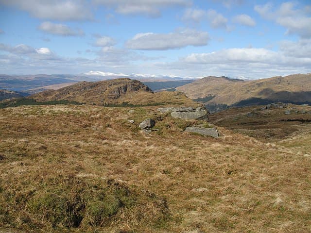
Beinn Bheag (619m), the small hill, rises above Loch Eck in the NS19 square on the Cowal peninsula, between the Holy Loch and Strachur. Its tiny summit cairn perches on a grass-and-heather knoll at the southern end of the long Glenbranter forest ridges, and the view stretches over Loch Eck to Argyll's Bowling Green hills. Forestry plantations cover much of the lower hill, with the open top tagged onto a network of forest roads.
Gaelic: “mountain, small” · Pronunciation: bine vek
Quick facts
- Height
- 619.8m/ 2033ft
- Prominence
- 302 m
- Distance
- 12 km
- Ascent
- 464 m
- Time
- 3–5 hrs
- Grid ref
- NS125931
- Parking
- NS116920
- Nearest city
- Oban· 46km
- Dogs
- Dogs on lead required near livestockDog-friendly guide ↗
Height and prominence cross-checked against the Database of British and Irish Hills (CC BY).
No GPX track yet
Walked this route? Share your track to help other walkers.
Standard route
heather and bog 65% · grass slopes 25% · rocky summit 10%
From the Glenbranter visitor parking near NS116920 follow the forest road network east and then north onto the ridge of Beinn Bheag. Take the open hillside above the deer fence directly to the summit — the small cairn is unmistakable on the highest knoll. About four and a half hours round, with the descent best taken via the same forest road exit to avoid getting lost in plantations.
Terrain
Forest road for the lower hill, then heather and rough grass above the treeline. Felled patches in the plantation can make navigation surprisingly tricky on the return. The open ridge has small peaty hollows that hold water after rain.
In winter
Cowal sits in the path of mild but very wet Atlantic systems, and Beinn Bheag rarely holds snow long. The forest tracks ice up readily in shaded sections, and gales can fell trees across the routes. The hill makes a reasonable winter outing once the cold sets in firmly.
Best time of year
Getting there
- Glasgow1h 17m
- Edinburgh2h 26m
OS maps: OS Landranger 56
Mobile signal: Minimal. Remote Argyll interior; coverage here is marginal.
Current conditions
Daylight Today
- Sunrise
- 04:57
- Sunset
- 21:55
- Civil dawn
- 04:02
- Civil dusk
- 22:51
NOAA Solar Calculator · 17 July 2026
On a long-distance route
Beinn Bheag sits within 5km of these named long-distance walks — useful for trail-pack rest days or section extensions.
Around Beinn Bheag on the SCOT network
Getting there, basing yourself, and what to do off the hill.
Getting there: Gourock station
Ferry to Dunoon and Kilcreggan; Inverclyde coast walks
19km from the hill
tripscot.co.uk
On TripSCOTBase yourself in Luss
West Loch Lomond village — Highland Boundary, Loch Lomond Way
23km from the hill
tripscot.co.uk
On TasteSCOTAfter the hill: Loch Lomond
Alexandria — sprawling distillery on the south end of the loch
29km from the hill
tastescot.co.uk
Beinn Bheag — common questions
- Is Beinn Bheag a hard climb?
- Beinn Bheag is rated 3/5 (moderately challenging) on the OutdoorSCOT scale. The standard route covers about 12km with 464m of ascent and takes most walkers 3-5 hours. Underfoot: Forest road for the lower hill, then heather and rough grass above the treeline.
- What is Beinn Bheag's prominence?
- 302m of prominence. That's the vertical drop from the summit to the col that links Beinn Bheag to the next higher ground.
- Where do I park for Beinn Bheag?
- Most walkers start from NS116920. Verify the grid reference on an OS map before you set off — space is tight on busy summer weekends.
- When is the best time to climb Beinn Bheag?
- March, April, May, June, July, August, September, October, November give the most reliable conditions on Beinn Bheag. Beyond that window the high ground turns wintry: carry full mountain kit, be confident navigating, and check the SAIS avalanche forecast for the area.
- Is Beinn Bheag dog-friendly?
- Yes, but dogs must be kept on a lead — there is livestock or ground-nesting bird interest on the route.
- Is there mobile signal on Beinn Bheag?
- Minimal. Remote Argyll interior; coverage here is marginal.
- Is Beinn Bheag safe in winter?
- Cowal sits in the path of mild but very wet Atlantic systems, and Beinn Bheag rarely holds snow long. The forest tracks ice up readily in shaded sections, and gales can fell trees across the routes. The hill makes a reasonable winter outing once the cold sets in firmly.
Get the OutdoorSCOT weekly
One email a week — new route, hill and bothy guides, seasonal conditions and the odd hard-won lesson. No spam, unsubscribe in one click.