Graham · Argyll & Bute
Creag Tharsuinn
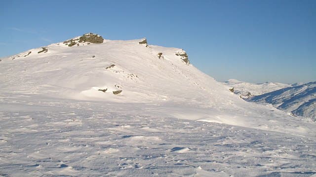
Creag Tharsuinn (643m) — the transverse crag — is the highest point of the Cowal peninsula in the NS08 square, looking south down Loch Striven and east over the Clyde to Arran. A flat rock marks the high point of a long heathery ridge cut by mature plantation on the lower slopes.
Quick facts
- Height
- 643m/ 2110ft
- Prominence
- 395 m
- Distance
- 12 km
- Ascent
- 482 m
- Time
- 3–5 hrs
- Grid ref
- NS087913
- Parking
- NS028873
- Nearest city
- Oban· 45km
- Dogs
- Dogs on lead required near livestockDog-friendly guide ↗
Height and prominence cross-checked against the Database of British and Irish Hills (CC BY).
No GPX track yet
Walked this route? Share your track to help other walkers.
Standard route
heather moorland 60% · grass slopes 25% · rocky summit 15%
Park at the head of Glendaruel where the B836 starts climbing east toward Loch Striven. Take the forestry road south, leaving it on a firebreak that strikes east up the ridge. Above the trees, the heathery crest leads gently south-east over false tops to the flat-rock summit on the east edge of the ridge.
Terrain
Forestry road and firebreak first, then heather and bog underfoot once on the crest. The flat-rock summit is unobtrusive and lies a short distance east of the obvious ridge cairn — confirm by altitude rather than landmark.
In winter
Cowal's maritime air keeps the ridge mostly snow-free, but cold easterlies plaster the heather with rime and ice. The firebreaks fill with drifted snow and become hard work; on the ridge itself, mist is the real difficulty as the false tops repeat themselves.
Best time of year
Getting there
- Glasgow1h 21m
- Edinburgh3h 31m
OS maps: OS Landranger 56
Mobile signal: Moderate. EE on the ridge for Clyde views; weaker in the plantation.
Current conditions
Daylight Today
- Sunrise
- 04:57
- Sunset
- 21:55
- Civil dawn
- 04:02
- Civil dusk
- 22:51
NOAA Solar Calculator · 17 July 2026
Around Creag Tharsuinn on the SCOT network
Getting there, basing yourself, and what to do off the hill.
Creag Tharsuinn — common questions
- Is Creag Tharsuinn a hard climb?
- Creag Tharsuinn is rated 3/5 (moderately challenging) on the OutdoorSCOT scale. The standard route covers about 12km with 482m of ascent and takes most walkers 3-5 hours. Terrain: Forestry road and firebreak first, then heather and bog underfoot once on the crest.
- How prominent is Creag Tharsuinn?
- Creag Tharsuinn has 395m of topographic prominence — the height of its summit above the highest col connecting it to higher ground.
- Where should I park to climb Creag Tharsuinn?
- Standard parking is at NS028873. Check the parking grid reference on an OS map before travel; informal laybys can fill on summer weekends.
- When should I climb Creag Tharsuinn?
- The standard good-weather months for Creag Tharsuinn are March, April, May, June, July, August, September, October, November. Outside those months, expect winter conditions on the high ground — full mountain kit, navigation skills, and a check of the SAIS avalanche forecast for the relevant region.
- Can I bring my dog up Creag Tharsuinn?
- On a lead only — the route crosses ground with livestock or nesting-bird interest.
- What's mobile reception like on Creag Tharsuinn?
- Moderate. EE on the ridge for Clyde views; weaker in the plantation.
- Is Creag Tharsuinn safe in winter?
- Cowal's maritime air keeps the ridge mostly snow-free, but cold easterlies plaster the heather with rime and ice. The firebreaks fill with drifted snow and become hard work; on the ridge itself, mist is the real difficulty as the false tops repeat themselves.
Get the OutdoorSCOT weekly
One email a week — new route, hill and bothy guides, seasonal conditions and the odd hard-won lesson. No spam, unsubscribe in one click.