Graham · Argyll & Bute
Beinn Mhor
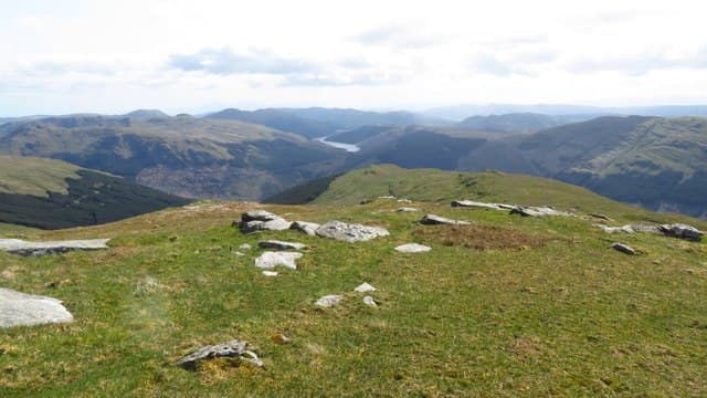
The highest hill in the Cowal peninsula, rising in a long grassy ridge between Glen Massan and Glen Lean and forming the centrepiece of the Argyll Forest Park. The summit panorama takes in the Holy Loch, Bute, Arran and the Arrochar Alps.
Gaelic: “mountain, big” · Pronunciation: bine vore
Quick facts
- Height
- 741.5m/ 2433ft
- Prominence
- 700 m
- Distance
- 14 km
- Ascent
- 608 m
- Time
- 4–6 hrs
- Grid ref
- NS107908
- Parking
- NS136878
- Nearest city
- Oban· 46km
- Dogs
- Dogs on lead required near livestockDog-friendly guide ↗
Height and prominence cross-checked against the Database of British and Irish Hills (CC BY).
No GPX track yet
Walked this route? Share your track to help other walkers.
Standard route
loch-side access 15% · heather hillside 50% · grassy upper slopes 25% · summit area 10%
From the parking at Inverchapel on Loch Eck side, walk west into Glen Massan and up the bridle path beside the Allt Eas Mhor. Above the trees an open grassy hillside leads south-west to the summit cairn.
Terrain
Forest road and bridle path low down, then steep wet grass and bracken to a broad grassy ridge. Few rocks above the treeline.
In winter
Cowal's damp climate rarely produces alpine conditions but heavy wet snow plasters the upper grass slopes and freezes overnight into hard glissade ground. The summit ridge offers no shelter from sou'westers.
Best time of year
Getting there
- Glasgow1h 18m
- Edinburgh2h 28m
OS maps: OS Landranger 56, OS Explorer 363
Mobile signal: No signal on this remote Argyll Graham above Loch Awe
Current conditions
Daylight Today
- Sunrise
- 04:57
- Sunset
- 21:55
- Civil dawn
- 04:02
- Civil dusk
- 22:51
NOAA Solar Calculator · 17 July 2026
On a long-distance route
Beinn Mhor sits within 5km of these named long-distance walks — useful for trail-pack rest days or section extensions.
Around Beinn Mhor on the SCOT network
Getting there, basing yourself, and what to do off the hill.
Getting there: Gourock station
Ferry to Dunoon and Kilcreggan; Inverclyde coast walks
18km from the hill
tripscot.co.uk
On TripSCOTBase yourself in Luss
West Loch Lomond village — Highland Boundary, Loch Lomond Way
25km from the hill
tripscot.co.uk
On TasteSCOTAfter the hill: Loch Lomond
Alexandria — sprawling distillery on the south end of the loch
30km from the hill
tastescot.co.uk
Beinn Mhor — common questions
- What difficulty is Beinn Mhor?
- On the OutdoorSCOT scale, Beinn Mhor comes in at 3/5 — moderately challenging. Expect roughly 14km and 608m of ascent on the usual route — 4-6 hours for most parties. Underfoot: Forest road and bridle path low down, then steep wet grass and bracken to a broad grassy ridge.
- What is Beinn Mhor's prominence?
- 700m of prominence. That's the vertical drop from the summit to the col that links Beinn Mhor to the next higher ground.
- Where do I park for Beinn Mhor?
- Most walkers start from NS136878. Verify the grid reference on an OS map before you set off — space is tight on busy summer weekends.
- When is the best time to climb Beinn Mhor?
- April, May, June, July, August, September, October give the most reliable conditions on Beinn Mhor. Beyond that window the high ground turns wintry: carry full mountain kit, be confident navigating, and check the SAIS avalanche forecast for the area.
- Is Beinn Mhor dog-friendly?
- Yes, but dogs must be kept on a lead — there is livestock or ground-nesting bird interest on the route.
- Is there mobile signal on Beinn Mhor?
- No signal on this remote Argyll Graham above Loch Awe
- Is Beinn Mhor safe in winter?
- Cowal's damp climate rarely produces alpine conditions but heavy wet snow plasters the upper grass slopes and freezes overnight into hard glissade ground. The summit ridge offers no shelter from sou'westers.
Get the OutdoorSCOT weekly
One email a week — new route, hill and bothy guides, seasonal conditions and the odd hard-won lesson. No spam, unsubscribe in one click.