Graham · Argyll & Bute
Sgorach Mor
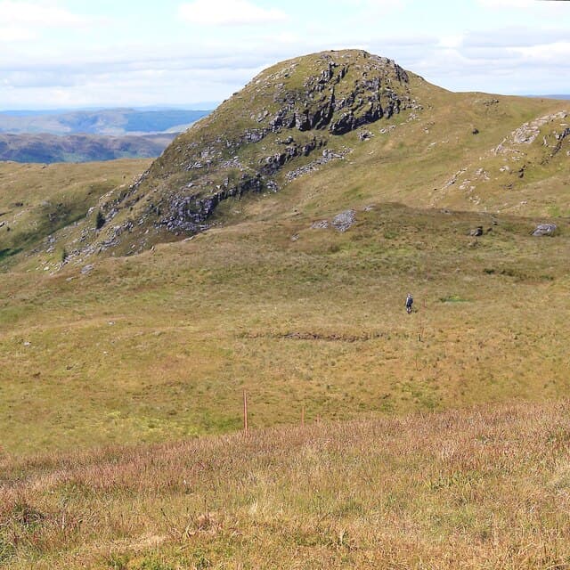
Sgorach Mor (602m) is the highest point on the wedge of upland between Loch Eck and the head of Loch Fyne, sitting at NS09 north of Strachur. Its substantial prominence of around 430m gives it the bearing of a proper hill day rather than a tick-and-go summit. A flat rock slab marks the high point, and the view sweeps from Beinn Bheula round the Arrochar Alps, with Loch Fyne stretching south-west and the Cowal forests filling the foreground.
Gaelic: “big” · Pronunciation: sgorach more
Quick facts
- Height
- 602.2m/ 1976ft
- Prominence
- 429 m
- Distance
- 12 km
- Ascent
- 452 m
- Time
- 3–5 hrs
- Grid ref
- NS096849
- Parking
- NS089869
- Nearest
- Oban· Glasgow 53km
- Dogs
- Dogs on lead required near livestockDog-friendly guide ↗
Height and prominence cross-checked against the Database of British and Irish Hills (CC BY).
No GPX track yet
Walked this route? Share your track to help other walkers.
Standard route
heather and bog 60% · rocky hillside 25% · grass slopes 15%
The cleanest line begins from the forest road at NS089869, climbing the long west ridge through open hillside above the felled plantation. Around 12km return with 452m of climb. Above the deer fence the ridge is open heather and grass; aim for the rocky bump at point 595 before continuing to the summit slab a kilometre to the south-east. A short detour to the north top adds half a kilometre and is worthwhile in clear weather.
Terrain
The west ridge is well-drained heather and short grass once free of the felled forestry, with bare schist showing through on the steepest steps. There is no continuous path but the line of the ridge is obvious. The summit dome is broad and slightly tilted east; the actual high point can be hard to identify by eye and the rock slab is worth seeking out.
In winter
Sgorach Mor sits close enough to the sea that any settled snow tends to be soggy rather than hard, but on cold high-pressure days the ridge ices over quickly and the steep step at point 595 wants careful footing. The forest road is normally driveable to within a few hundred metres of the start. With the SAIS Southern Highlands forecast covering the wider area, conditions are usually well known by the time you set out.
Best time of year
Getting there
- Glasgow1h 16m
- Edinburgh2h 28m
OS maps: OS Landranger 56
Mobile signal: Poor. Remote Ardnamurchan; very limited coverage.
Current conditions
Daylight Today
- Sunrise
- 04:52
- Sunset
- 22:00
- Civil dawn
- 03:55
- Civil dusk
- 22:57
NOAA Solar Calculator · 13 July 2026
On a long-distance route
Sgorach Mor sits within 5km of these named long-distance walks — useful for trail-pack rest days or section extensions.
Around Sgorach Mor on the SCOT network
Getting there, basing yourself, and what to do off the hill.
Getting there: Gourock station
Ferry to Dunoon and Kilcreggan; Inverclyde coast walks
16km from the hill
tripscot.co.uk
On TripSCOTBase yourself in Rothesay
Isle of Bute base; West Island Way; short Glasgow break
20km from the hill
tripscot.co.uk
On TasteSCOTAfter the hill: Loch Lomond
Alexandria — sprawling distillery on the south end of the loch
29km from the hill
tastescot.co.uk
Sgorach Mor — common questions
- What difficulty is Sgorach Mor?
- On the OutdoorSCOT scale, Sgorach Mor comes in at 3/5 — moderately challenging. Expect roughly 12km and 452m of ascent on the usual route — 3-5 hours for most parties. Terrain: The west ridge is well-drained heather and short grass once free of the felled forestry, with bare schist showing through on the steepest steps.
- How prominent is Sgorach Mor?
- Sgorach Mor has 429m of topographic prominence — the height of its summit above the highest col connecting it to higher ground.
- Where should I park to climb Sgorach Mor?
- Standard parking is at NS089869 near Oban. Check the parking grid reference on an OS map before travel; informal laybys can fill on summer weekends.
- When should I climb Sgorach Mor?
- The standard good-weather months for Sgorach Mor are March, April, May, June, July, August, September, October, November. Outside those months, expect winter conditions on the high ground — full mountain kit, navigation skills, and a check of the SAIS avalanche forecast for the relevant region.
- Can I bring my dog up Sgorach Mor?
- On a lead only — the route crosses ground with livestock or nesting-bird interest.
- What's mobile reception like on Sgorach Mor?
- Poor. Remote Ardnamurchan; very limited coverage.
- Is Sgorach Mor safe in winter?
- Sgorach Mor sits close enough to the sea that any settled snow tends to be soggy rather than hard, but on cold high-pressure days the ridge ices over quickly and the steep step at point 595 wants careful footing. The forest road is normally driveable to within a few hundred metres of the start. With the SAIS Southern Highlands forecast covering the wider area, conditions are usually well known by the time you set out.
Get the OutdoorSCOT weekly
One email a week — new route, hill and bothy guides, seasonal conditions and the odd hard-won lesson. No spam, unsubscribe in one click.