Graham · Argyll & Bute
Cruach nan Capull
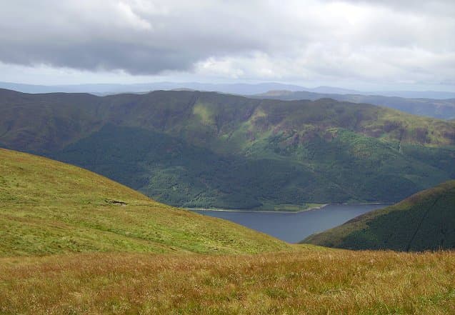
Cruach nan Capull (612m), the horse mountain, dominates the southern half of the Cowal peninsula in the NS09 square, between Loch Striven and Loch Riddon. A small rock summit sits at the top of a steep, broken north flank that gives the hill its distinctive profile when viewed from the Kyles of Bute. The prominence figure of 486m means the climb feels notably bigger than the headline height suggests.
Quick facts
- Height
- 612m/ 2008ft
- Prominence
- 486 m
- Distance
- 12 km
- Ascent
- 459 m
- Time
- 3–5 hrs
- Grid ref
- NS095795
- Parking
- NS083837
- Nearest city
- Glasgow· 52km
- Dogs
- Dogs on lead required near livestockDog-friendly guide ↗
Height and prominence cross-checked against the Database of British and Irish Hills (CC BY).
No GPX track yet
Walked this route? Share your track to help other walkers.
Standard route
heather and bog 65% · grass slopes 25% · rocky summit 10%
From the parking spot at NS083837 north of Inverchaolain, follow the forest road south through the plantation before stepping out onto the open hill. The line up the north shoulder gives the simplest ascent, picking through outcrops on grass-and-heather terraces. About five hours round trip, returning the same way to avoid steep, crag-fringed ground on the west flank.
Terrain
Forestry roads provide a clean start, but felling and replanting have made some sections of map out of date. The open hill is heather and bog with grassy benches between rocky steps. The summit rock is a small clean platform with a giddy west view.
In winter
Cowal gets less snow than the Highlands but Cruach nan Capull's north face holds verglas in any cold spell, and the crags become a real hazard. Forestry roads ice over in shaded sections. The hill is a good winter half-day in settled cold weather, with the south ridge offering the safest descent line.
Best time of year
Getting there
- Glasgow1h 14m
- Edinburgh2h 28m
OS maps: OS Landranger 63
Mobile signal: Minimal. Remote Cowal interior; coverage here is marginal.
Current conditions
Daylight Today
- Sunrise
- 04:52
- Sunset
- 22:00
- Civil dawn
- 03:55
- Civil dusk
- 22:57
NOAA Solar Calculator · 13 July 2026
Around Cruach nan Capull on the SCOT network
Getting there, basing yourself, and what to do off the hill.
Getting there: Gourock station
Ferry to Dunoon and Kilcreggan; Inverclyde coast walks
14km from the hill
tripscot.co.uk
On TripSCOTBase yourself in Rothesay
Isle of Bute base; West Island Way; short Glasgow break
15km from the hill
tripscot.co.uk
On TasteSCOTAfter the hill: Loch Lomond
Alexandria — sprawling distillery on the south end of the loch
29km from the hill
tastescot.co.uk
Cruach nan Capull — common questions
- What difficulty is Cruach nan Capull?
- On the OutdoorSCOT scale, Cruach nan Capull comes in at 3/5 — moderately challenging. Expect roughly 12km and 459m of ascent on the usual route — 3-5 hours for most parties. Ground conditions: Forestry roads provide a clean start, but felling and replanting have made some sections of map out of date.
- How much drop does Cruach nan Capull have?
- The drop is 486m: measured from the summit of Cruach nan Capull down to the saddle joining it to higher terrain.
- Where's the parking for Cruach nan Capull?
- Park at NS083837. Double-check the grid reference on an OS map first; informal laybys here fill early in high season.
- What's the best month to climb Cruach nan Capull?
- Aim for March, April, May, June, July, August, September, October, November on Cruach nan Capull. In the remaining months treat it as a winter hill — full kit, solid navigation, and a look at the relevant SAIS avalanche forecast before you go.
- Can dogs go up Cruach nan Capull?
- Dogs are fine on a lead. The route passes livestock or ground-nesting bird habitat, so keep them close throughout.
- Will I get phone signal on Cruach nan Capull?
- Minimal. Remote Cowal interior; coverage here is marginal.
- Is Cruach nan Capull safe in winter?
- Cowal gets less snow than the Highlands but Cruach nan Capull's north face holds verglas in any cold spell, and the crags become a real hazard. Forestry roads ice over in shaded sections. The hill is a good winter half-day in settled cold weather, with the south ridge offering the safest descent line.
Get the OutdoorSCOT weekly
One email a week — new route, hill and bothy guides, seasonal conditions and the odd hard-won lesson. No spam, unsubscribe in one click.