Graham · Argyll & Bute
Cruach Neuran
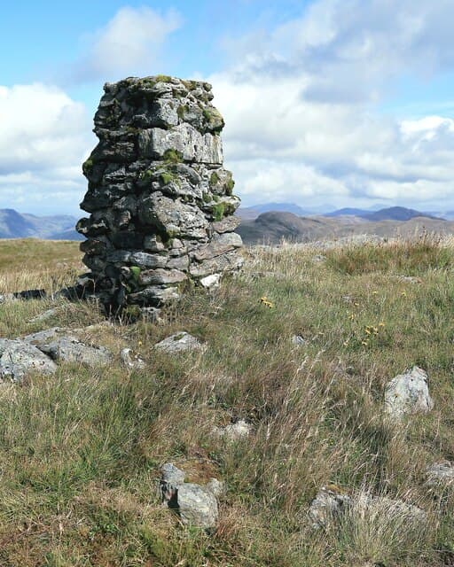
Cruach Neuran (607m) is a heather-clad Cowal Graham in the NS08 square, lifting steeply between Loch Striven and the wooded shores of Loch Riddon. The trig pillar on its small summit dome looks east over Bute and the upper Clyde, north to the Arrochar Alps and south down the long finger of Loch Striven toward Toward Point. Despite its proximity to Glasgow this is one of the quieter Cowal hills, with no through path and few cairned trods.
Quick facts
- Height
- 607m/ 1991ft
- Prominence
- 296 m
- Distance
- 12 km
- Ascent
- 455 m
- Time
- 3–5 hrs
- Grid ref
- NS083820
- Parking
- NS090809
- Nearest
- Oban· Glasgow 53km
- Dogs
- Dogs on lead required near livestockDog-friendly guide ↗
Height and prominence cross-checked against the Database of British and Irish Hills (CC BY).
No GPX track yet
Walked this route? Share your track to help other walkers.
Standard route
heather and bog 65% · grass slopes 25% · rocky summit 10%
Approach is usually from Glendaruel-side, following the forestry road from NS090809 east into Glen Tarsan before quitting the track and climbing the broad western flank. The round trip is around 12km with 455m of ascent. Above the felled forest edge the slope is open grass and heather, rising in steady gradient to the trig at the top. Re-tracing the same line back through the gaps in the plantation is the simplest descent.
Terrain
The forestry has been progressively felled and replanted; brash and stumps make the line out of the trees frustrating. Above the deer fence the hill opens into long heather and pockets of bog myrtle, with the odd wet runnel cutting across the line of ascent. The summit area is firm short grass dotted with peat hags around the trig pillar.
In winter
Soft Cowal snowfalls rarely consolidate but the felled forestry collects deep drifts in gulleys and around stumps. The mossy bog below the summit freezes into hard hummocks that are awkward for crampons. Daylight is reasonable this far south but the maritime cloud base often sits at 400m for days on end — pick a clear high-pressure day if you want a view.
Best time of year
Getting there
- Glasgow1h 16m
- Edinburgh3h 30m
OS maps: OS Landranger 56
Mobile signal: Expect little. Remote Argyll interior; signal is marginal here.
Current conditions
Daylight Today
- Sunrise
- 04:52
- Sunset
- 22:00
- Civil dawn
- 03:55
- Civil dusk
- 22:57
NOAA Solar Calculator · 13 July 2026
On a long-distance route
Cruach Neuran sits within 5km of these named long-distance walks — useful for trail-pack rest days or section extensions.
Around Cruach Neuran on the SCOT network
Getting there, basing yourself, and what to do off the hill.
Cruach Neuran — common questions
- What difficulty is Cruach Neuran?
- On the OutdoorSCOT scale, Cruach Neuran comes in at 3/5 — moderately challenging. Expect roughly 12km and 455m of ascent on the usual route — 3-5 hours for most parties. Terrain: The forestry has been progressively felled and replanted; brash and stumps make the line out of the trees frustrating.
- How prominent is Cruach Neuran?
- Cruach Neuran has 296m of topographic prominence — the height of its summit above the highest col connecting it to higher ground.
- Where should I park to climb Cruach Neuran?
- Standard parking is at NS090809 near Oban. Check the parking grid reference on an OS map before travel; informal laybys can fill on summer weekends.
- When should I climb Cruach Neuran?
- The standard good-weather months for Cruach Neuran are March, April, May, June, July, August, September, October, November. Outside those months, expect winter conditions on the high ground — full mountain kit, navigation skills, and a check of the SAIS avalanche forecast for the relevant region.
- Can I bring my dog up Cruach Neuran?
- On a lead only — the route crosses ground with livestock or nesting-bird interest.
- What's mobile reception like on Cruach Neuran?
- Expect little. Remote Argyll interior; signal is marginal here.
- Is Cruach Neuran safe in winter?
- Soft Cowal snowfalls rarely consolidate but the felled forestry collects deep drifts in gulleys and around stumps. The mossy bog below the summit freezes into hard hummocks that are awkward for crampons. Daylight is reasonable this far south but the maritime cloud base often sits at 400m for days on end — pick a clear high-pressure day if you want a view.
Get the OutdoorSCOT weekly
One email a week — new route, hill and bothy guides, seasonal conditions and the odd hard-won lesson. No spam, unsubscribe in one click.