Graham · Argyll & Bute
Cruach nam Miseag
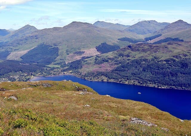
Cruach nam Miseag (607m) sits at NS18 above the head of Loch Goil, a broad-backed Cowal Graham within sight of the Arrochar peaks but rarely visited in its own right. A small cairn marks the summit on a turfy crown, with the eye drawn west over Hell's Glen and the rough country toward Beinn Bheula. The hill's position between Lochgoilhead and Strachur means walkers tend to pass through rather than linger.
Quick facts
- Height
- 607m/ 1991ft
- Prominence
- 206 m
- Distance
- 12 km
- Ascent
- 455 m
- Time
- 3–5 hrs
- Grid ref
- NS182981
- Parking
- NS172973
- Nearest city
- Oban· 45km
- Dogs
- Dogs on lead required near livestockDog-friendly guide ↗
Height and prominence cross-checked against the Database of British and Irish Hills (CC BY).
No GPX track yet
Walked this route? Share your track to help other walkers.
Standard route
heather and bog 65% · grass slopes 25% · rocky summit 10%
The shortest line begins from the Hell's Glen road at NS172973, gaining height quickly through the deer fence and onto the open south-west ridge. The day works out at around 12km and 455m of climb if combined with a circuit of the higher tops; an out-and-back to the summit alone trims that considerably. Bracken on the lower slopes is shoulder-high in late summer, but once above 400m the going becomes short grass and bilberry.
Terrain
The bracken belt on the lower south-west flank is dense enough to swallow the line of small drainage gullies in summer — late autumn or early spring make the going much easier. Higher up the gradient eases onto a turfy plateau cut by shallow peat runnels. There is no continuous path; navigation is straightforward in clear weather but the rolling top can disorientate in mist.
In winter
Cowal's mild winters mean Cruach nam Miseag rarely carries deep snow, but the south-west ridge holds verglas after cold clear nights and the steep slope above the road can be hard ice. The summit dome is broad and featureless; a clear bearing from cairn to descent line is wise in poor visibility. Sunset rolls in early behind the Arrochar peaks even on a clear December afternoon.
Best time of year
Getting there
- Glasgow1h 15m
- Edinburgh2h 20m
OS maps: OS Landranger 56
Mobile signal: Weak. Remote Argyll; weak on most networks.
Current conditions
Daylight Today
- Sunrise
- 04:50
- Sunset
- 22:00
- Civil dawn
- 03:53
- Civil dusk
- 22:58
NOAA Solar Calculator · 13 July 2026
On a long-distance route
Cruach nam Miseag sits within 5km of these named long-distance walks — useful for trail-pack rest days or section extensions.
Around Cruach nam Miseag on the SCOT network
Getting there, basing yourself, and what to do off the hill.
Getting there: Arrochar & Tarbet station
Arrochar Alps — The Cobbler, Beinn Ime, Beinn Narnain, Ben Vane, Ben Vorlich
14km from the hill
tripscot.co.uk
On TripSCOTBase yourself in Luss
West Loch Lomond village — Highland Boundary, Loch Lomond Way
18km from the hill
tripscot.co.uk
On TasteSCOTAfter the hill: Loch Lomond
Alexandria — sprawling distillery on the south end of the loch
27km from the hill
tastescot.co.uk
Cruach nam Miseag — common questions
- How difficult is Cruach nam Miseag?
- Cruach nam Miseag carries a 3/5 (moderately challenging) grade on the OutdoorSCOT scale. Count on about 12km, 455m of ascent and a 3-5 hour day on the standard route. Terrain: The bracken belt on the lower south-west flank is dense enough to swallow the line of small drainage gullies in summer — late autumn or early spring make the going much easier.
- How prominent is Cruach nam Miseag?
- Cruach nam Miseag has 206m of topographic prominence — the height of its summit above the highest col connecting it to higher ground.
- Where should I park to climb Cruach nam Miseag?
- Standard parking is at NS172973. Check the parking grid reference on an OS map before travel; informal laybys can fill on summer weekends.
- When should I climb Cruach nam Miseag?
- The standard good-weather months for Cruach nam Miseag are March, April, May, June, July, August, September, October, November. Outside those months, expect winter conditions on the high ground — full mountain kit, navigation skills, and a check of the SAIS avalanche forecast for the relevant region.
- Can I bring my dog up Cruach nam Miseag?
- On a lead only — the route crosses ground with livestock or nesting-bird interest.
- What's mobile reception like on Cruach nam Miseag?
- Weak. Remote Argyll; weak on most networks.
- Is Cruach nam Miseag safe in winter?
- Cowal's mild winters mean Cruach nam Miseag rarely carries deep snow, but the south-west ridge holds verglas after cold clear nights and the steep slope above the road can be hard ice. The summit dome is broad and featureless; a clear bearing from cairn to descent line is wise in poor visibility. Sunset rolls in early behind the Arrochar peaks even on a clear December afternoon.
Get the OutdoorSCOT weekly
One email a week — new route, hill and bothy guides, seasonal conditions and the odd hard-won lesson. No spam, unsubscribe in one click.