Munro · Arrochar & Trossachs
Beinn Bhuidhe
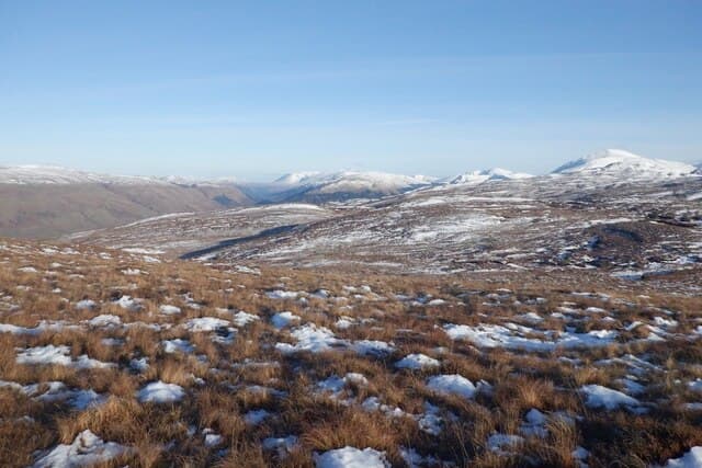
Beinn Bhuidhe (948m) — "yellow hill" — is a solitary Munro at the head of Glen Fyne in Argyll, the southernmost Munro in the county and notable for its long approach across estate tracks. Despite the modest height the hill stands genuinely alone with 592m of prominence — no realistic option to combine with another Munro. The summit gives commanding views across Loch Fyne south to the Kintyre peninsula.
Quick facts
- Height
- 948.5m/ 3112ft
- Prominence
- 592 m
- Distance
- 16 km
- Ascent
- 835 m
- Time
- 5–8 hrs
- Grid ref
- NN203187
- Parking
- NN191124
- Nearest city
- Oban· 36km
- Dogs
- Dogs on lead required near livestockDog-friendly guide ↗
Height and prominence cross-checked against the Database of British and Irish Hills (CC BY).
No GPX track yet
Walked this route? Share your track to help other walkers.
Standard route
Glen track 40% · Open hillside 40% · Summit 20%
Park at the head of Glen Fyne, north of Inveraray on the A83 turning into the long Glen Fyne road. Walk north up the firm estate landrover track for around 6km to the foot of the hill, then climb the steep south-east shoulder of Beinn Bhuidhe directly to the summit. Return reverses the line. Around 17km return with 840m of ascent — a long approach for a single Munro.
Terrain
The Glen Fyne estate landrover track gives firm fast surface for the long valley approach. Beyond the track the south-east shoulder climbs sustained heather and broken rock with a thin braided path. A small flat top holds the summit cairn alongside the base of an old trig pillar. Above the estate road the hill is genuinely trackless.
In winter
A serious mid-grade Southern Highlands winter day, the demand coming from the long approach. The south-east shoulder gathers wind-loaded snow under westerly storms. The Glen Fyne road can drift but the A83 corridor at Inveraray stays gritted. SAIS Southern Cairngorms is the nearest regional avalanche reference. Mobile reception fades above 700m.
This hill is in the Southern Highlands SAIS forecast area. Check SAIS forecasts in winter (December–April).
Best time of year
Getting there
- Glasgow2h 34m
- Edinburgh2h 26m
OS maps: OS Landranger 50, OS Landranger 56
Mobile signal: No reception above 700m. The Glen Fyne road has intermittent coverage. Download maps ahead of the drive up Glen Fyne from Inveraray.
Current conditions
Daylight Today
- Sunrise
- 05:05
- Sunset
- 21:47
- Civil dawn
- 04:12
- Civil dusk
- 22:41
NOAA Solar Calculator · 23 July 2026
Pair with
Curated multi-hill combinations from Beinn Bhuidhe.
Around Beinn Bhuidhe on the SCOT network
Getting there, basing yourself, and what to do off the hill.
Beinn Bhuidhe — common questions
- How difficult is Beinn Bhuidhe?
- Beinn Bhuidhe carries a 4/5 (challenging) grade on the OutdoorSCOT scale. Count on about 16km, 835m of ascent and a 5-8 hour day on the standard route. Ground conditions: The Glen Fyne estate landrover track gives firm fast surface for the long valley approach.
- How much drop does Beinn Bhuidhe have?
- The drop is 592m: measured from the summit of Beinn Bhuidhe down to the saddle joining it to higher terrain.
- Where's the parking for Beinn Bhuidhe?
- Park at NN191124. Double-check the grid reference on an OS map first; informal laybys here fill early in high season.
- What's the best month to climb Beinn Bhuidhe?
- Aim for May, June, July, August, September, October on Beinn Bhuidhe. In the remaining months treat it as a winter hill — full kit, solid navigation, and a look at the relevant SAIS avalanche forecast before you go.
- Can dogs go up Beinn Bhuidhe?
- Dogs are fine on a lead. The route passes livestock or ground-nesting bird habitat, so keep them close throughout.
- Will I get phone signal on Beinn Bhuidhe?
- No reception above 700m. The Glen Fyne road has intermittent coverage. Download maps ahead of the drive up Glen Fyne from Inveraray.
- Is Beinn Bhuidhe safe in winter?
- A serious mid-grade Southern Highlands winter day, the demand coming from the long approach. The south-east shoulder gathers wind-loaded snow under westerly storms. The Glen Fyne road can drift but the A83 corridor at Inveraray stays gritted. SAIS Southern Cairngorms is the nearest regional avalanche reference. Mobile reception fades above 700m.
Get the OutdoorSCOT weekly
One email a week — new route, hill and bothy guides, seasonal conditions and the odd hard-won lesson. No spam, unsubscribe in one click.