Graham · Arrochar & Trossachs
Beinn Bhalgairean
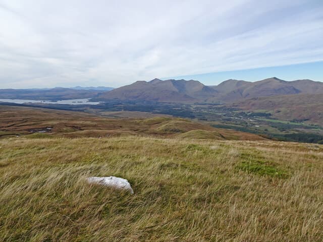
Beinn Bhalgairean (636m) stands above Glen Strae in the NN21 square, west of Dalmally where Loch Awe carves the country between the Trossachs and Argyll. A quartz capstone marks the broad summit and on clear afternoons Cruachan, Ben Lui and the head of Loch Awe spread out in turn. The hill is reached most commonly from the B8077 above Glen Strae and provides a quiet alternative to the bigger Munros on its doorstep.
Quick facts
- Height
- 636.8m/ 2089ft
- Prominence
- 210 m
- Distance
- 12 km
- Ascent
- 477 m
- Time
- 3–5 hrs
- Grid ref
- NN202241
- Parking
- NN214239
- Nearest city
- Oban· 35km
- Dogs
- Dogs on lead required near livestockDog-friendly guide ↗
Height and prominence cross-checked against the Database of British and Irish Hills (CC BY).
No GPX track yet
Walked this route? Share your track to help other walkers.
Standard route
heather moorland 65% · grass slopes 25% · rocky outcrops 10%
From parking at NN214239 a faint quad track climbs through bracken before opening onto deer grass and heather above 300m. Above the wooded lower flanks the angle eases onto a long whaleback of grass studded with quartz outcrops. The summit is unmissable once gained, a low rib of stone overlooking the head of the loch. Allow about three hours up and back, with the descent best done via the ascent line — the south-east face is steeper and broken than it appears from below.
Terrain
Grass and heather predominate, with occasional quartzite blocks emerging higher up. The single quad track soon fades, leaving open hillside that walks cleanly in dry weather but turns sodden after rain. Burns drain south into Glen Strae and can be awkward to cross in spate.
In winter
Loch Awe sits in a frequent rain-shadow then catches sudden snow showers off Cruachan, so the upper slopes can ice over quickly. Above 500m the quartz becomes slippery under thin verglas. The walk is well within reach for an unhurried winter outing when the weather is calm, but the western aspect leaves you exposed once cloud rolls in off the Atlantic.
This hill is in the Southern Highlands SAIS forecast area. Check SAIS forecasts in winter (December–April).
Best time of year
Getting there
- Glasgow2h 41m
- Edinburgh2h 29m
OS maps: OS Landranger 50
Mobile signal: Poor. Remote Argyll/Cowal; coverage here is marginal.
Current conditions
Daylight Today
- Sunrise
- 04:49
- Sunset
- 22:02
- Civil dawn
- 03:50
- Civil dusk
- 23:00
NOAA Solar Calculator · 13 July 2026
Around Beinn Bhalgairean on the SCOT network
Getting there, basing yourself, and what to do off the hill.
Beinn Bhalgairean — common questions
- Is Beinn Bhalgairean a hard climb?
- Beinn Bhalgairean is rated 3/5 (moderately challenging) on the OutdoorSCOT scale. The standard route covers about 12km with 477m of ascent and takes most walkers 3-5 hours. Terrain: Grass and heather predominate, with occasional quartzite blocks emerging higher up.
- How prominent is Beinn Bhalgairean?
- Beinn Bhalgairean has 210m of topographic prominence — the height of its summit above the highest col connecting it to higher ground.
- Where should I park to climb Beinn Bhalgairean?
- Standard parking is at NN214239. Check the parking grid reference on an OS map before travel; informal laybys can fill on summer weekends.
- When should I climb Beinn Bhalgairean?
- The standard good-weather months for Beinn Bhalgairean are March, April, May, June, July, August, September, October, November. Outside those months, expect winter conditions on the high ground — full mountain kit, navigation skills, and a check of the SAIS avalanche forecast for the relevant region.
- Can I bring my dog up Beinn Bhalgairean?
- On a lead only — the route crosses ground with livestock or nesting-bird interest.
- What's mobile reception like on Beinn Bhalgairean?
- Poor. Remote Argyll/Cowal; coverage here is marginal.
- Is Beinn Bhalgairean safe in winter?
- Loch Awe sits in a frequent rain-shadow then catches sudden snow showers off Cruachan, so the upper slopes can ice over quickly. Above 500m the quartz becomes slippery under thin verglas. The walk is well within reach for an unhurried winter outing when the weather is calm, but the western aspect leaves you exposed once cloud rolls in off the Atlantic.
Get the OutdoorSCOT weekly
One email a week — new route, hill and bothy guides, seasonal conditions and the odd hard-won lesson. No spam, unsubscribe in one click.