Graham · Glen Coe & Lochaber
Beinn Donachain
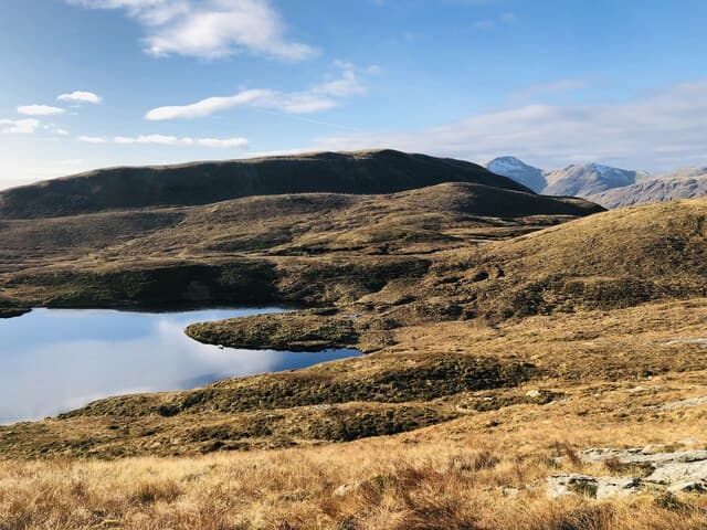
Beinn Donachain (651m) is the southern guardian of Glen Strae in the NN13 square, north-east of Dalmally. A rocky outcrop marks the top of a steep cone with the Bridge of Orchy Munros to the north and Loch Awe spread south in fine arcs of water.
Quick facts
- Height
- 651.4m/ 2137ft
- Prominence
- 376 m
- Distance
- 13 km
- Ascent
- 534 m
- Time
- 3–6 hrs
- Grid ref
- NN198316
- Parking
- NN156291
- Nearest city
- Oban· 34km
- Dogs
- Dogs on lead required near livestockDog-friendly guide ↗
Height and prominence cross-checked against the Database of British and Irish Hills (CC BY).
No GPX track yet
Walked this route? Share your track to help other walkers.
Standard route
heather moorland 65% · grass slopes 20% · rocky summit 15%
Park at Castles Farm at the foot of Glen Strae. Take the estate track north up the glen for two kilometres, then leave it to cross the river and climb the steep west spur direct. The rocky cone above is hard work for the legs but quickly rewarded by the outcrop and its panorama.
Terrain
Glen Strae track at the start, then a river crossing that can be tricky in spate. The west spur is steep grass and bracken with rock breaks; the summit cone is a fine little climb with hand-and-foot moves at the very top.
In winter
Glen Strae receives heavy west-coast precipitation and the cone of Beinn Donachain rimes up beautifully. Wind slab can form on the lee north flank; the river crossing also runs high after thaws. SAIS Glencoe forecasts cover this western edge of the area.
This hill is in the Glen Coe SAIS forecast area. Check SAIS forecasts in winter (December–April).
Best time of year
Getting there
- Glasgow2h 50m
- Edinburgh3h 34m
OS maps: OS Landranger 50
Mobile signal: Poor. Remote Glen Strae north of Dalmally; weak on most networks.
Current conditions
Daylight Today
- Sunrise
- 04:48
- Sunset
- 22:02
- Civil dawn
- 03:50
- Civil dusk
- 23:01
NOAA Solar Calculator · 13 July 2026
Around Beinn Donachain on the SCOT network
Getting there, basing yourself, and what to do off the hill.
Beinn Donachain — common questions
- How difficult is Beinn Donachain?
- Beinn Donachain carries a 3/5 (moderately challenging) grade on the OutdoorSCOT scale. Count on about 13km, 534m of ascent and a 3-6 hour day on the standard route. Ground conditions: Glen Strae track at the start, then a river crossing that can be tricky in spate.
- How much drop does Beinn Donachain have?
- The drop is 376m: measured from the summit of Beinn Donachain down to the saddle joining it to higher terrain.
- Where's the parking for Beinn Donachain?
- Park at NN156291. Double-check the grid reference on an OS map first; informal laybys here fill early in high season.
- What's the best month to climb Beinn Donachain?
- Aim for March, April, May, June, July, August, September, October, November on Beinn Donachain. In the remaining months treat it as a winter hill — full kit, solid navigation, and a look at the relevant SAIS avalanche forecast before you go.
- Can dogs go up Beinn Donachain?
- Dogs are fine on a lead. The route passes livestock or ground-nesting bird habitat, so keep them close throughout.
- Will I get phone signal on Beinn Donachain?
- Poor. Remote Glen Strae north of Dalmally; weak on most networks.
- Is Beinn Donachain safe in winter?
- Glen Strae receives heavy west-coast precipitation and the cone of Beinn Donachain rimes up beautifully. Wind slab can form on the lee north flank; the river crossing also runs high after thaws. SAIS Glencoe forecasts cover this western edge of the area.
Get the OutdoorSCOT weekly
One email a week — new route, hill and bothy guides, seasonal conditions and the odd hard-won lesson. No spam, unsubscribe in one click.