Munro · Arrochar & Trossachs
Ben Lui (Beinn Laoigh)
Ben Lui — Beinn Laoigh, "calf mountain" — is the 1131m Munro that dominates the country between Tyndrum and Dalmally, often called the finest mountain in profile in the Southern Highlands. The summit is a shapely peak above the great north-east corrie of Coire Gaothach, a horseshoe of cliffs that holds snow late into spring and gives one of the most photogenic outlines of any Scottish hill. The mountain is the source of the River Tay — the spring rising near the summit feeds Scotland's longest river system.
Quick facts
- Height
- 1131.4m/ 3712ft
- Prominence
- 876 m
- Distance
- 18 km
- Ascent
- 996 m
- Time
- 6–9 hrs
- Grid ref
- NN266262
- Parking
- NN343291
- Nearest city
- Oban· 41km
- Dogs
- Dogs on lead required near livestockDog-friendly guide ↗
Height and prominence cross-checked against the Database of British and Irish Hills (CC BY).
No GPX track yet
Walked this route? Share your track to help other walkers.
Standard route
Glen path 35% · Open hillside 30% · Summit cone 35%
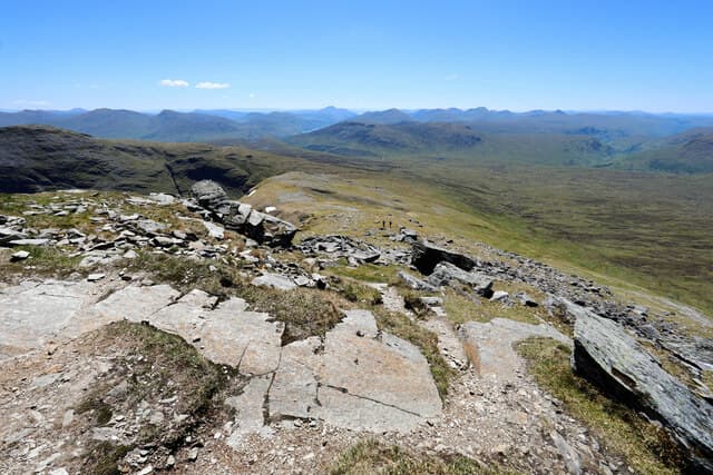
The classic line is from the Dalrigh car park north-west of Tyndrum, following the path past Cononish Farm and up Allt an Rund into Coire Gaothach. From the corrie floor, climb the south-east shoulder of Ben Lui onto the summit ridge. Around 18km return with 996m of ascent. Most parties combine with neighbouring Beinn a' Chleibh for a two-Munro day. The Glen Lochy approach from the west is shorter but rougher; not the standard line.
Terrain
The Cononish farm track is firm gravel past the working gold mine. Above the farm the path turns to rough heather and stones; the climb out of Coire Gaothach is on steep grass and rock. The narrow summit ridge has significant exposure to the corrie below. The Central Gully which sometimes attracts descent traffic in summer is steep and loose — keep on the standard south-east shoulder.
In winter
Coire Gaothach is a major Scottish winter climbing venue (Grade I-IV routes including the classic Central Gully). Cornices form along the corrie rim continuously through the season. The Central Gully has been the site of fatal avalanches. The south-east shoulder approach is the safest winter line. The Dalrigh A82 lay-by is gritted; the Cononish track ices over. SAIS Southern Cairngorms is the closest report.
This hill is in the Southern Highlands SAIS forecast area. Check SAIS forecasts in winter (December–April).
Best time of year
Getting there
- Glasgow2h 39m
- Edinburgh2h 23m
OS maps: OS Landranger 50
Mobile signal: Moderate signal at Dalrigh car park on the A82. Signal weakens on the approach through Glen Cononish. No reliable signal above 800m.
Current conditions
Daylight Today
- Sunrise
- 05:04
- Sunset
- 21:47
- Civil dawn
- 04:11
- Civil dusk
- 22:41
NOAA Solar Calculator · 23 July 2026
Pair with
Curated multi-hill combinations from Ben Lui (Beinn Laoigh).
Around Ben Lui (Beinn Laoigh) on the SCOT network
Getting there, basing yourself, and what to do off the hill.
Ben Lui (Beinn Laoigh) — common questions
- What difficulty is Ben Lui (Beinn Laoigh)?
- On the OutdoorSCOT scale, Ben Lui (Beinn Laoigh) comes in at 4/5 — challenging. Expect roughly 18km and 996m of ascent on the usual route — 6-9 hours for most parties. Terrain: The Cononish farm track is firm gravel past the working gold mine.
- How prominent is Ben Lui (Beinn Laoigh)?
- Ben Lui (Beinn Laoigh) has 876m of topographic prominence — the height of its summit above the highest col connecting it to higher ground.
- Where should I park to climb Ben Lui (Beinn Laoigh)?
- Standard parking is at NN343291. Check the parking grid reference on an OS map before travel; informal laybys can fill on summer weekends.
- When should I climb Ben Lui (Beinn Laoigh)?
- The standard good-weather months for Ben Lui (Beinn Laoigh) are May, June, July, August, September, October. Outside those months, expect winter conditions on the high ground — full mountain kit, navigation skills, and a check of the SAIS avalanche forecast for the relevant region.
- Can I bring my dog up Ben Lui (Beinn Laoigh)?
- On a lead only — the route crosses ground with livestock or nesting-bird interest.
- What's mobile reception like on Ben Lui (Beinn Laoigh)?
- Moderate signal at Dalrigh car park on the A82. Signal weakens on the approach through Glen Cononish. No reliable signal above 800m.
- Is Ben Lui (Beinn Laoigh) safe in winter?
- Coire Gaothach is a major Scottish winter climbing venue (Grade I-IV routes including the classic Central Gully). Cornices form along the corrie rim continuously through the season. The Central Gully has been the site of fatal avalanches. The south-east shoulder approach is the safest winter line. The Dalrigh A82 lay-by is gritted; the Cononish track ices over. SAIS Southern Cairngorms is the closest report.
Get the OutdoorSCOT weekly
One email a week — new route, hill and bothy guides, seasonal conditions and the odd hard-won lesson. No spam, unsubscribe in one click.