Graham · Arrochar & Trossachs
Cruinn a' Bheinn
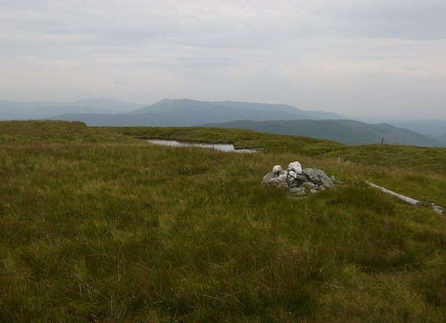
Cruinn a' Bheinn (632m), the round mountain, sits behind Rowardennan in the NN36 square, north of the eastern shore of Loch Lomond. The summit cairn stands at the apex of a smoothly rounded grass dome that gives a remarkably full sweep of the loch and a close look at the north face of Ben Lomond. The hill is most often climbed as a back-extension to Ben Lomond rather than alone.
Quick facts
- Height
- 632.5m/ 2075ft
- Prominence
- 178 m
- Distance
- 12 km
- Ascent
- 474 m
- Time
- 3–5 hrs
- Grid ref
- NN365051
- Parking
- NN364045
- Nearest city
- Stirling· 45km
- Dogs
- Dogs on lead required near livestockDog-friendly guide ↗
Height and prominence cross-checked against the Database of British and Irish Hills (CC BY).
No GPX track yet
Walked this route? Share your track to help other walkers.
Standard route
heather moorland 65% · grass slopes 25% · rocky summit 10%
From the Sallochy car park area at NN364045 take the West Highland Way north before peeling east into Glen Dubh past the ruined steading. A faint stalkers' path climbs the south-east shoulder onto the grass dome. Allow about five and a half hours for the round; the descent should reverse the route to skirt the steep crags above the loch.
Terrain
Birchwood and bracken on the loch-side lower slopes give way to short grass higher up. The summit dome is straightforward but cut by small peaty channels that flow into the Caorann Burn. The crags above the loch are hidden until you are near them — avoid the west flank in cloud.
In winter
Low altitude keeps Cruinn a' Bheinn snow-free much of winter, but when Ben Lomond holds snow this hill catches drift on its lee slopes. The lochside path can be greasy with ice in shaded sections. A short midwinter day is feasible in settled weather, with the main risk being the steep west face if mist drops.
This hill is in the Southern Highlands SAIS forecast area. Check SAIS forecasts in winter (December–April).
Best time of year
Getting there
- Glasgow1h 5m
- Edinburgh2h 0m
OS maps: OS Landranger 56
Mobile signal: Minimal. Remote Loch Lochy area; thin on most networks.
Current conditions
Daylight Today
- Sunrise
- 04:55
- Sunset
- 21:55
- Civil dawn
- 03:59
- Civil dusk
- 22:51
NOAA Solar Calculator · 17 July 2026
On a long-distance route
Cruinn a' Bheinn sits within 5km of these named long-distance walks — useful for trail-pack rest days or section extensions.
Around Cruinn a' Bheinn on the SCOT network
Getting there, basing yourself, and what to do off the hill.
Getting there: Arrochar & Tarbet station
Arrochar Alps — The Cobbler, Beinn Ime, Beinn Narnain, Ben Vane, Ben Vorlich
6km from the hill
tripscot.co.uk
On TripSCOTBase yourself in Luss
West Loch Lomond village — Highland Boundary, Loch Lomond Way
12km from the hill
tripscot.co.uk
On TasteSCOTAfter the hill: Loch Lomond
Alexandria — sprawling distillery on the south end of the loch
25km from the hill
tastescot.co.uk
Cruinn a' Bheinn — common questions
- How difficult is Cruinn a' Bheinn?
- Cruinn a' Bheinn carries a 3/5 (moderately challenging) grade on the OutdoorSCOT scale. Count on about 12km, 474m of ascent and a 3-5 hour day on the standard route. Ground conditions: Birchwood and bracken on the loch-side lower slopes give way to short grass higher up.
- How much drop does Cruinn a' Bheinn have?
- The drop is 178m: measured from the summit of Cruinn a' Bheinn down to the saddle joining it to higher terrain.
- Where's the parking for Cruinn a' Bheinn?
- Park at NN364045. Double-check the grid reference on an OS map first; informal laybys here fill early in high season.
- What's the best month to climb Cruinn a' Bheinn?
- Aim for March, April, May, June, July, August, September, October, November on Cruinn a' Bheinn. In the remaining months treat it as a winter hill — full kit, solid navigation, and a look at the relevant SAIS avalanche forecast before you go.
- Can dogs go up Cruinn a' Bheinn?
- Dogs are fine on a lead. The route passes livestock or ground-nesting bird habitat, so keep them close throughout.
- Will I get phone signal on Cruinn a' Bheinn?
- Minimal. Remote Loch Lochy area; thin on most networks.
- Is Cruinn a' Bheinn safe in winter?
- Low altitude keeps Cruinn a' Bheinn snow-free much of winter, but when Ben Lomond holds snow this hill catches drift on its lee slopes. The lochside path can be greasy with ice in shaded sections. A short midwinter day is feasible in settled weather, with the main risk being the steep west face if mist drops.
Get the OutdoorSCOT weekly
One email a week — new route, hill and bothy guides, seasonal conditions and the odd hard-won lesson. No spam, unsubscribe in one click.