Munro · Arrochar & Trossachs
Stob Binnein
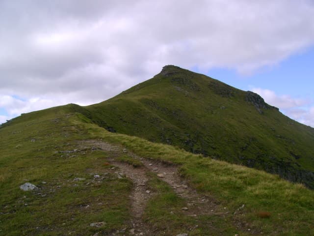
Stob Binnein is the 1165m Munro twin of Ben More, joined to it by the high Bealach-eadar-dha-Bheinn 1km north. At only nine metres lower than its better-known sibling, Stob Binnein is a more shapely pyramid in profile — the textbook conical mountain seen from Strathfillan and Loch Earn. The summit cairn perches at the apex of a long south ridge that runs down to Inverlochlarig and the head of Loch Voil. Almost always done in tandem with Ben More on the same day.
Quick facts
- Height
- 1164.8m/ 3822ft
- Prominence
- 304 m
- Distance
- 19 km
- Ascent
- 1025 m
- Time
- 6–9 hrs
- Grid ref
- NN434227
- Parking
- NN414258
- Nearest city
- Stirling· 47km
- Dogs
- Dogs on lead required near livestockDog-friendly guide ↗
Height and prominence cross-checked against the Database of British and Irish Hills (CC BY).
No GPX track yet
Walked this route? Share your track to help other walkers.
Standard route
Path / open hillside 30% · Steep hillside 40% · Summit cone 30%
The standard line is the Ben More / Stob Binnein round from Benmore Farm on the A85. After Ben More, descend south to the deep Bealach-eadar-dha-Bheinn (1164m), then climb the long grass-and-rock north ridge to the Stob Binnein cairn. Around 12-14km return with 1025m of ascent for the pair. An alternative is the south approach from Inverlochlarig at the head of Loch Voil — longer but with the gentler grass south ridge, useful in bad weather.
Terrain
The Benmore Farm path is firm on the Ben More side. The bealach itself is broad grass and easy walking. The north ridge of Stob Binnein is sustained grass and rocky steps, no scrambling required but careful footwork on the steeper sections. The summit is a small cairn on a narrow grassy crest. The south ridge to Inverlochlarig is gentler — useful for descent options.
In winter
A serious winter Munro with the same risk profile as Ben More next door. The bealach is exposed to wind; the north face holds avalanche-prone snow after westerly storms. Cornices form on the east edge of the summit ridge. The Inverlochlarig road can be closed by drifting snow. SAIS Southern Cairngorms gives a regional indicator.
This hill is in the Southern Highlands SAIS forecast area. Check SAIS forecasts in winter (December–April).
Best time of year
Getting there
- Glasgow1h 25m
- Edinburgh2h 2m
OS maps: OS Landranger 51
Mobile signal: Moderate signal at Benmore Farm car park. Signal usually absent from mid-slope upward. Part of the Ben More/Stob Binnein circuit.
Current conditions
Daylight Today
- Sunrise
- 05:03
- Sunset
- 21:46
- Civil dawn
- 04:10
- Civil dusk
- 22:40
NOAA Solar Calculator · 23 July 2026
Pair with
Curated multi-hill combinations from Stob Binnein.
Around Stob Binnein on the SCOT network
Getting there, basing yourself, and what to do off the hill.
Stob Binnein — common questions
- What difficulty is Stob Binnein?
- On the OutdoorSCOT scale, Stob Binnein comes in at 3/5 — moderately challenging. Expect roughly 19km and 1025m of ascent on the usual route — 6-9 hours for most parties. Ground conditions: The Benmore Farm path is firm on the Ben More side.
- How much drop does Stob Binnein have?
- The drop is 304m: measured from the summit of Stob Binnein down to the saddle joining it to higher terrain.
- Where's the parking for Stob Binnein?
- Park at NN414258. Double-check the grid reference on an OS map first; informal laybys here fill early in high season.
- What's the best month to climb Stob Binnein?
- Aim for May, June, July, August, September, October on Stob Binnein. In the remaining months treat it as a winter hill — full kit, solid navigation, and a look at the relevant SAIS avalanche forecast before you go.
- Can dogs go up Stob Binnein?
- Dogs are fine on a lead. The route passes livestock or ground-nesting bird habitat, so keep them close throughout.
- Will I get phone signal on Stob Binnein?
- Moderate signal at Benmore Farm car park. Signal usually absent from mid-slope upward. Part of the Ben More/Stob Binnein circuit.
- Is Stob Binnein safe in winter?
- A serious winter Munro with the same risk profile as Ben More next door. The bealach is exposed to wind; the north face holds avalanche-prone snow after westerly storms. Cornices form on the east edge of the summit ridge. The Inverlochlarig road can be closed by drifting snow. SAIS Southern Cairngorms gives a regional indicator.
Get the OutdoorSCOT weekly
One email a week — new route, hill and bothy guides, seasonal conditions and the odd hard-won lesson. No spam, unsubscribe in one click.