Munro · Arrochar & Trossachs
Cruach Ardrain
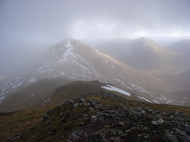
Cruach Àrdrain (1045m) is the dominant Munro of the Crianlarich group — the cluster of summits visible to walkers heading north on the A82 as it climbs past Crianlarich into the Highlands proper. The peak forms a distinctive twin-topped pyramid seen from the A85 to the south, with a steep south face above the Allt Coire Ardrain. Almost always paired with the adjoining Beinn Tulaichean, which sits as a southern outlier connected by a high broad ridge.
Quick facts
- Height
- 1045.9m/ 3431ft
- Prominence
- 549 m
- Distance
- 18 km
- Ascent
- 920 m
- Time
- 6–9 hrs
- Grid ref
- NN409212
- Parking
- NN385253
- Nearest city
- Stirling· 48km
- Dogs
- Dogs on lead required near livestockDog-friendly guide ↗
Height and prominence cross-checked against the Database of British and Irish Hills (CC BY).
No GPX track yet
Walked this route? Share your track to help other walkers.
Standard route
Forest / glen track 35% · Open hillside 40% · Summit ridge 25%
Park on the forest road south of Crianlarich village (small lay-by off the A82). Take the forestry tracks east and south, then climb out of the trees onto the open hill at the head of the Allt Coire Ardrain. Climb the steep north-west ridge to the false summit at Stob Garbh, then south-east to the true summit cairn of Cruach Àrdrain. Continue south to Beinn Tulaichean and return via the same line. The pair total roughly 13km with 1100m of climb.
Terrain
The forestry approach is firm landrover track but very wet underfoot in places after rain. Above the trees the ground is rough heather and broken slabs of mica-schist; the path picks an indirect line through the rocky bands. The north-west ridge has a section of steep eroded scree below the false summit. The summit ridge between Cruach Àrdrain's two tops is short and rocky with one easy scramble. The ridge to Beinn Tulaichean is broad grassy turf.
In winter
A serious mid-grade winter Munro by Southern Highlands standards. The steep south-east face above Coire Earb is recognised as an avalanche slope after westerly loading. Cornicing on the north-east edge of the summit ridge is consistent. The A82 corridor stays gritted and Crianlarich is one of the better-serviced winter trailheads. SAIS Southern Cairngorms is the closest formal report. Phone signal at Crianlarich is moderate; weak on the hill.
This hill is in the Southern Highlands SAIS forecast area. Check SAIS forecasts in winter (December–April).
Best time of year
Getting there
- Glasgow1h 24m
- Edinburgh2h 4m
OS maps: OS Landranger 51, OS Landranger 56
Mobile signal: Moderate signal at Crianlarich village. Signal weakens above 700m.
Current conditions
Daylight Today
- Sunrise
- 05:04
- Sunset
- 21:46
- Civil dawn
- 04:10
- Civil dusk
- 22:40
NOAA Solar Calculator · 23 July 2026
Pair with
Curated multi-hill combinations from Cruach Ardrain.
Around Cruach Ardrain on the SCOT network
Getting there, basing yourself, and what to do off the hill.
Cruach Ardrain — common questions
- What difficulty is Cruach Ardrain?
- On the OutdoorSCOT scale, Cruach Ardrain comes in at 4/5 — challenging. Expect roughly 18km and 920m of ascent on the usual route — 6-9 hours for most parties. Terrain: The forestry approach is firm landrover track but very wet underfoot in places after rain.
- How prominent is Cruach Ardrain?
- Cruach Ardrain has 549m of topographic prominence — the height of its summit above the highest col connecting it to higher ground.
- Where should I park to climb Cruach Ardrain?
- Standard parking is at NN385253. Check the parking grid reference on an OS map before travel; informal laybys can fill on summer weekends.
- When should I climb Cruach Ardrain?
- The standard good-weather months for Cruach Ardrain are May, June, July, August, September, October. Outside those months, expect winter conditions on the high ground — full mountain kit, navigation skills, and a check of the SAIS avalanche forecast for the relevant region.
- Can I bring my dog up Cruach Ardrain?
- On a lead only — the route crosses ground with livestock or nesting-bird interest.
- What's mobile reception like on Cruach Ardrain?
- Moderate signal at Crianlarich village. Signal weakens above 700m.
- Is Cruach Ardrain safe in winter?
- A serious mid-grade winter Munro by Southern Highlands standards. The steep south-east face above Coire Earb is recognised as an avalanche slope after westerly loading. Cornicing on the north-east edge of the summit ridge is consistent. The A82 corridor stays gritted and Crianlarich is one of the better-serviced winter trailheads. SAIS Southern Cairngorms is the closest formal report. Phone signal at Crianlarich is moderate; weak on the hill.
Get the OutdoorSCOT weekly
One email a week — new route, hill and bothy guides, seasonal conditions and the odd hard-won lesson. No spam, unsubscribe in one click.