Graham · Arrochar & Trossachs
Mor Bheinn
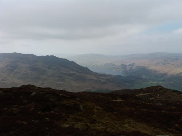
Mor Bheinn (640m) — the big hill — rises south of Loch Earn in the NN72 square, looking north to Ben Vorlich across the loch and south over Glen Artney to Glen Eagles. A rock and trig point share the high point on a broad grassy crown above woodland.
Gaelic: “big” · Pronunciation: more bheinn
Quick facts
- Height
- 640.3m/ 2101ft
- Prominence
- 327 m
- Distance
- 12 km
- Ascent
- 480 m
- Time
- 3–5 hrs
- Grid ref
- NN716211
- Parking
- NN712161
- Nearest city
- Stirling· 29km
- Dogs
- Dogs on lead required near livestockDog-friendly guide ↗
Height and prominence cross-checked against the Database of British and Irish Hills (CC BY).
No GPX track yet
Walked this route? Share your track to help other walkers.
Standard route
heather and bog 65% · grass slopes 25% · rocky summit 10%
Park at Glen Artney church car park south-east of Comrie. Walk along the public road into upper Glen Artney for about a kilometre, then take a quad rut north-west onto the shoulder. A long gentle ascent across grass and scattered rock leads onto the broad crown and so to the trig point with its neighbouring rock platform.
Terrain
Tarred road and farm track at the start, then short grass and bracken on the shoulder. The summit dome is firm and open; the rock beside the trig pillar makes a comfortable place to sit out a brew.
In winter
Glen Artney sees light, blown snow that drifts on the open dome. Mor Bheinn lacks steep ground but the trig area is fully exposed to south-westerlies. Ice on the grass is the usual concern rather than deep snow; a short January day fits easily from Comrie.
This hill is in the Southern Highlands SAIS forecast area. Check SAIS forecasts in winter (December–April).
Best time of year
Getting there
- Glasgow1h 21m
- Edinburgh2h 42m
OS maps: OS Landranger 51, OS Landranger 52, OS Landranger 57
Mobile signal: Moderate. EE on the open crown; weaker in Glen Artney.
Current conditions
Daylight Today
- Sunrise
- 04:52
- Sunset
- 21:53
- Civil dawn
- 03:55
- Civil dusk
- 22:50
NOAA Solar Calculator · 17 July 2026
On a long-distance route
Mor Bheinn sits within 5km of these named long-distance walks — useful for trail-pack rest days or section extensions.
Around Mor Bheinn on the SCOT network
Getting there, basing yourself, and what to do off the hill.
Getting there: Dunblane station
Stirling-area; Sheriffmuir; gateway north
21km from the hill
tripscot.co.uk
On TripSCOTBase yourself in Callander
Trossachs gateway — Ben Ledi, Stuc a Chroin, Rob Roy Way
16km from the hill
tripscot.co.uk
On TasteSCOTAfter the hill: The Glenturret
Crieff — Scotland's oldest working distillery; Famous Grouse Experience
13km from the hill
tastescot.co.uk
Mor Bheinn — common questions
- Is Mor Bheinn a hard climb?
- Mor Bheinn is rated 3/5 (moderately challenging) on the OutdoorSCOT scale. The standard route covers about 12km with 480m of ascent and takes most walkers 3-5 hours. Ground conditions: Tarred road and farm track at the start, then short grass and bracken on the shoulder.
- How much drop does Mor Bheinn have?
- The drop is 327m: measured from the summit of Mor Bheinn down to the saddle joining it to higher terrain.
- Where's the parking for Mor Bheinn?
- Park at NN712161. Double-check the grid reference on an OS map first; informal laybys here fill early in high season.
- What's the best month to climb Mor Bheinn?
- Aim for March, April, May, June, July, August, September, October, November on Mor Bheinn. In the remaining months treat it as a winter hill — full kit, solid navigation, and a look at the relevant SAIS avalanche forecast before you go.
- Can dogs go up Mor Bheinn?
- Dogs are fine on a lead. The route passes livestock or ground-nesting bird habitat, so keep them close throughout.
- Will I get phone signal on Mor Bheinn?
- Moderate. EE on the open crown; weaker in Glen Artney.
- Is Mor Bheinn safe in winter?
- Glen Artney sees light, blown snow that drifts on the open dome. Mor Bheinn lacks steep ground but the trig area is fully exposed to south-westerlies. Ice on the grass is the usual concern rather than deep snow; a short January day fits easily from Comrie.
Get the OutdoorSCOT weekly
One email a week — new route, hill and bothy guides, seasonal conditions and the odd hard-won lesson. No spam, unsubscribe in one click.