Graham · Central Belt
Uamh Bheag
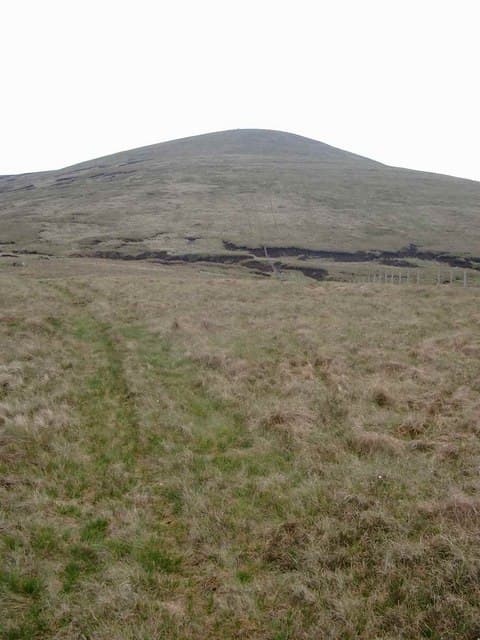
Uamh Bheag (665m) — the small cave — rises north of Callander in the NN61 square, the high point of the Braes of Doune moorland that bounds the Trossachs on its eastern side. A fence junction beside the summit cairn marks the true top. The view stretches south over the Forth valley to the Pentlands and Edinburgh's skyline on the rarest clear days.
Gaelic: “small” · Pronunciation: uamh vek
Quick facts
- Height
- 665.8m/ 2184ft
- Prominence
- 325 m
- Distance
- 13 km
- Ascent
- 545 m
- Time
- 3–6 hrs
- Grid ref
- NN691118
- Parking
- NN660137
- Nearest city
- Stirling· 21km
- Dogs
- Dogs on lead required near livestockDog-friendly guide ↗
Height and prominence cross-checked against the Database of British and Irish Hills (CC BY).
No GPX track yet
Walked this route? Share your track to help other walkers.
Standard route
heather and bracken 55% · grass slopes 30% · rocky summit 15%
Park at the Callander Crags car park north of the town and take the path through the woods to gain the broad moor. Climb gradually north-east on a quad rut through heather and bilberry, with the long ridge of the Braes of Doune rising steadily ahead. The cairn sits at a fence junction on a low rise — easy walking once on the open hill.
Terrain
Wooded path from Callander, then quad ruts through ankle-deep heather and bilberry on the broad ridge. The summit area is gently rolling with the fence junction as the chief landmark. Easy walking throughout but the moor turns boggy in any wet spell.
In winter
Trossachs winters tend to be wet rather than cold and Uamh Bheag rarely holds deep snow — patches of frozen rush and skim ice on the moor pools are more typical. The view of snow-covered higher peaks to the north is the chief winter draw. Wind chill from south-westerlies can be sharp on the open ridge.
Best time of year
Getting there
- Glasgow1h 8m
- Edinburgh2h 37m
OS maps: OS Landranger 57
Mobile signal: Moderate. EE weak on top; stronger on southern aspects toward Callander.
Current conditions
Daylight Today
- Sunrise
- 04:52
- Sunset
- 21:53
- Civil dawn
- 03:56
- Civil dusk
- 22:49
NOAA Solar Calculator · 17 July 2026
Around Uamh Bheag on the SCOT network
Getting there, basing yourself, and what to do off the hill.
Getting there: Dunblane station
Stirling-area; Sheriffmuir; gateway north
14km from the hill
tripscot.co.uk
On TripSCOTBase yourself in Callander
Trossachs gateway — Ben Ledi, Stuc a Chroin, Rob Roy Way
7km from the hill
tripscot.co.uk
On TasteSCOTAfter the hill: Deanston
Doune — converted cotton mill; floral, honeyed Perthshire distillery
12km from the hill
tastescot.co.uk
Uamh Bheag — common questions
- Is Uamh Bheag a hard climb?
- Uamh Bheag is rated 3/5 (moderately challenging) on the OutdoorSCOT scale. The standard route covers about 13km with 545m of ascent and takes most walkers 3-6 hours. Ground conditions: Wooded path from Callander, then quad ruts through ankle-deep heather and bilberry on the broad ridge.
- How much drop does Uamh Bheag have?
- The drop is 325m: measured from the summit of Uamh Bheag down to the saddle joining it to higher terrain.
- Where's the parking for Uamh Bheag?
- Park at NN660137. Double-check the grid reference on an OS map first; informal laybys here fill early in high season.
- What's the best month to climb Uamh Bheag?
- Aim for March, April, May, June, July, August, September, October, November on Uamh Bheag. In the remaining months treat it as a winter hill — full kit, solid navigation, and a look at the relevant SAIS avalanche forecast before you go.
- Can dogs go up Uamh Bheag?
- Dogs are fine on a lead. The route passes livestock or ground-nesting bird habitat, so keep them close throughout.
- Will I get phone signal on Uamh Bheag?
- Moderate. EE weak on top; stronger on southern aspects toward Callander.
- Is Uamh Bheag safe in winter?
- Trossachs winters tend to be wet rather than cold and Uamh Bheag rarely holds deep snow — patches of frozen rush and skim ice on the moor pools are more typical. The view of snow-covered higher peaks to the north is the chief winter draw. Wind chill from south-westerlies can be sharp on the open ridge.
Get the OutdoorSCOT weekly
One email a week — new route, hill and bothy guides, seasonal conditions and the odd hard-won lesson. No spam, unsubscribe in one click.