Munro · Fife & Perthshire
Meall Corranaich
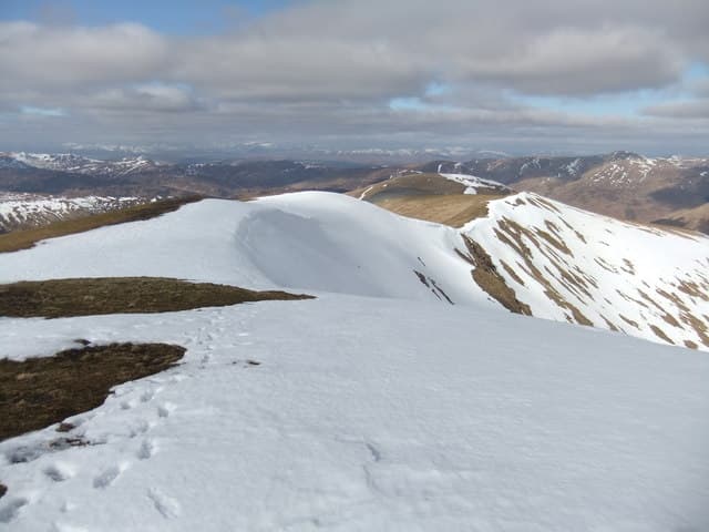
Meall Corranaich (1067m) is the westernmost of the seven Munros of the Ben Lawers range above Loch Tay. It is the shapely whaleback seen on the right as you drive over the Lochan na Lairige road from Killin. Most parties pair it with Meall a' Choire Lèith, the next Munro to the north, for a relatively short day from the high road. The summit panorama spans Ben Lawers itself, Schiehallion to the north-east and the Crianlarich hills to the west.
Quick facts
- Height
- 1067.2m/ 3501ft
- Prominence
- 201 m
- Distance
- 10 km
- Ascent
- 736 m
- Time
- 4–5 hrs
- Grid ref
- NN615410
- Parking
- NN594416
- Nearest city
- Stirling· 51km
- Dogs
- Dogs on lead required near livestockDog-friendly guide ↗
Height and prominence cross-checked against the Database of British and Irish Hills (CC BY).
No GPX track yet
Walked this route? Share your track to help other walkers.
Standard route
Good path then open hillside 40% · Open hillside 40% · Summit 20%
Park in the small lay-by at the high point of the Lochan na Lairige road, just south of the dam. Climb east up the broad south-west ridge of Meall Corranaich on a clear path. From the summit drop north-east to the bealach and continue over to Meall a' Choire Lèith, then return the same way or descend west to the Lochan na Lairige reservoir and follow the road back. Around 9km with 770m of ascent for the pair; Corranaich alone is 6km with 540m up.
Terrain
The south-west ridge from the Lochan na Lairige lay-by gives an easy, well-trodden walking line on short grass and gravel. The summit cone has a narrow stone cairn perched above the steep north corrie. The drop to the bealach for Meall a' Choire Lèith is steep mossy turf with a single rocky step. The Lochan na Lairige road itself is narrow single-track tarmac — drive carefully.
In winter
A relatively short winter day but the high road approach can be drifted closed in heavy snow; check NTS Ben Lawers updates before driving. Westerly storms wind-load the north-east face, building avalanche risk into late winter. Persistent cornicing affects the north and east margins of the summit ridge. For avalanche guidance the SAIS Southern Cairngorms forecast is the nearest official source. Bring full winter kit despite the modest distance.
Best time of year
Getting there
- Glasgow2h 48m
- Edinburgh2h 58m
OS maps: OS Landranger 51
Mobile signal: Good signal at the NTS car park below Ben Lawers. Signal weakens on the western approach above 800m. Download the OS map before arriving.
Current conditions
Daylight Today
- Sunrise
- 05:01
- Sunset
- 21:46
- Civil dawn
- 04:07
- Civil dusk
- 22:40
NOAA Solar Calculator · 23 July 2026
Pair with
Curated multi-hill combinations from Meall Corranaich.
Around Meall Corranaich on the SCOT network
Getting there, basing yourself, and what to do off the hill.
Getting there: Rannoch station
Rannoch Moor — remote West Highland Line stop; Schiehallion approach via bus
26km from the hill
tripscot.co.uk
On TripSCOTBase yourself in Aberfeldy
Loch Tay base — Ben Lawers, Tarmachan ridge, Birks of Aberfeldy
25km from the hill
tripscot.co.uk
On TasteSCOTAfter the hill: Aberfeldy
Aberfeldy — heart of Dewar's blends; honey-and-heather Highland style
26km from the hill
tastescot.co.uk
Meall Corranaich — common questions
- What difficulty is Meall Corranaich?
- On the OutdoorSCOT scale, Meall Corranaich comes in at 4/5 — challenging. Expect roughly 10km and 736m of ascent on the usual route — 4-5 hours for most parties. Terrain: The south-west ridge from the Lochan na Lairige lay-by gives an easy, well-trodden walking line on short grass and gravel.
- How prominent is Meall Corranaich?
- Meall Corranaich has 201m of topographic prominence — the height of its summit above the highest col connecting it to higher ground.
- Where should I park to climb Meall Corranaich?
- Standard parking is at NN594416. Check the parking grid reference on an OS map before travel; informal laybys can fill on summer weekends.
- When should I climb Meall Corranaich?
- The standard good-weather months for Meall Corranaich are May, June, July, August, September, October. Outside those months, expect winter conditions on the high ground — full mountain kit, navigation skills, and a check of the SAIS avalanche forecast for the relevant region.
- Can I bring my dog up Meall Corranaich?
- On a lead only — the route crosses ground with livestock or nesting-bird interest.
- What's mobile reception like on Meall Corranaich?
- Good signal at the NTS car park below Ben Lawers. Signal weakens on the western approach above 800m. Download the OS map before arriving.
- Is Meall Corranaich safe in winter?
- A relatively short winter day but the high road approach can be drifted closed in heavy snow; check NTS Ben Lawers updates before driving. Westerly storms wind-load the north-east face, building avalanche risk into late winter. Persistent cornicing affects the north and east margins of the summit ridge. For avalanche guidance the SAIS Southern Cairngorms forecast is the nearest official source. Bring full winter kit despite the modest distance.
Get the OutdoorSCOT weekly
One email a week — new route, hill and bothy guides, seasonal conditions and the odd hard-won lesson. No spam, unsubscribe in one click.