Munro · Fife & Perthshire
An Stuc
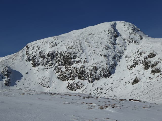
An Stuc — "the pinnacle" — is the steepest and most rocky of the Ben Lawers group of Munros, sitting between Meall Garbh and Ben Lawers itself on the long Lawers ridge. At 1118m it has the most exposed summit of any hill in the range, with a famous steep north-side scramble onto the cap that catches out parties expecting a straightforward Munro. The rocky summit is a large boulder on a small platform with sustained drops on three sides.
Quick facts
- Height
- 1117.1m/ 3665ft
- Prominence
- 126 m
- Distance
- 18 km
- Ascent
- 983 m
- Time
- 6–9 hrs
- Grid ref
- NN638431
- Parking
- NN608378
- Nearest city
- Perth· 52km
- Dogs
- Dogs on lead required near livestockDog-friendly guide ↗
Height and prominence cross-checked against the Database of British and Irish Hills (CC BY).
No GPX track yet
Walked this route? Share your track to help other walkers.
Standard route
Good path 35% · Steep hillside 30% · Rocky scramble 35%
Almost always tackled as part of the Ben Lawers ridge traverse from the NTS visitor centre. The crucial section is the north-side scramble onto An Stuc from the col below Meall Garbh — a steep Grade 1 scramble on grass and rock with significant exposure. Around 18km return with 983m of ascent for the four-Munro Lawers round including An Stuc. Avoid in wet or icy conditions.
Terrain
The NTS Lawers paths are well-built. The Meall Garbh / An Stuc col is short grass. The north-side scramble is steep grass and rock with significant exposure to the east; sustained Grade 1 ground. The summit boulder is reached after a brief easy section. Descent south to Lawers is on a steep loose rocky path that requires care.
In winter
A serious winter Munro. The An Stuc scramble becomes a Grade I/II winter climb under snow and ice with full exposure; fatal accidents have occurred on the descent in poor conditions. Cornicing on the north side adds risk. Most winter parties reverse the day to descend the An Stuc step in better conditions. SAIS Southern Cairngorms applies.
Best time of year
Getting there
- Glasgow2h 51m
- Edinburgh2h 58m
OS maps: OS Landranger 51
Mobile signal: Good signal at the NTS car park below Ben Lawers. Signal diminishes above 900m. The northern corrie approach has no signal. Download Landranger 51 offline.
Current conditions
Daylight Today
- Sunrise
- 05:01
- Sunset
- 21:46
- Civil dawn
- 04:07
- Civil dusk
- 22:40
NOAA Solar Calculator · 23 July 2026
Pair with
Curated multi-hill combinations from An Stuc.
Around An Stuc on the SCOT network
Getting there, basing yourself, and what to do off the hill.
Getting there: Rannoch station
Rannoch Moor — remote West Highland Line stop; Schiehallion approach via bus
27km from the hill
tripscot.co.uk
On TripSCOTBase yourself in Aberfeldy
Loch Tay base — Ben Lawers, Tarmachan ridge, Birks of Aberfeldy
22km from the hill
tripscot.co.uk
On TasteSCOTAfter the hill: Aberfeldy
Aberfeldy — heart of Dewar's blends; honey-and-heather Highland style
23km from the hill
tastescot.co.uk
An Stuc — common questions
- Is An Stuc a hard climb?
- An Stuc is rated 4/5 (challenging) on the OutdoorSCOT scale. The standard route covers about 18km with 983m of ascent and takes most walkers 6-9 hours. Ground conditions: The NTS Lawers paths are well-built.
- How much drop does An Stuc have?
- The drop is 126m: measured from the summit of An Stuc down to the saddle joining it to higher terrain.
- Where's the parking for An Stuc?
- Park at NN608378. Double-check the grid reference on an OS map first; informal laybys here fill early in high season.
- What's the best month to climb An Stuc?
- Aim for May, June, July, August, September, October on An Stuc. In the remaining months treat it as a winter hill — full kit, solid navigation, and a look at the relevant SAIS avalanche forecast before you go.
- Can dogs go up An Stuc?
- Dogs are fine on a lead. The route passes livestock or ground-nesting bird habitat, so keep them close throughout.
- Will I get phone signal on An Stuc?
- Good signal at the NTS car park below Ben Lawers. Signal diminishes above 900m. The northern corrie approach has no signal. Download Landranger 51 offline.
- Is An Stuc safe in winter?
- A serious winter Munro. The An Stuc scramble becomes a Grade I/II winter climb under snow and ice with full exposure; fatal accidents have occurred on the descent in poor conditions. Cornicing on the north side adds risk. Most winter parties reverse the day to descend the An Stuc step in better conditions. SAIS Southern Cairngorms applies.
Get the OutdoorSCOT weekly
One email a week — new route, hill and bothy guides, seasonal conditions and the odd hard-won lesson. No spam, unsubscribe in one click.