Graham · Fife & Perthshire
Leagag
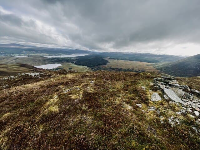
Leagag (601m) is a quiet Graham sitting in the NN51 square on the southern flank of the Schiehallion massif, between Loch Rannoch and the deep cleft of Gleann Mor. A small turfy cairn marks the top, with Schiehallion's pyramid dominating the view north and Loch Rannoch winking through the trees to the west. The hill is generally walked as a solo outing or as a shoulder warm-up before tackling Schiehallion proper.
Quick facts
- Height
- 601m/ 1972ft
- Prominence
- 215 m
- Distance
- 12 km
- Ascent
- 451 m
- Time
- 3–5 hrs
- Grid ref
- NN518539
- Parking
- NN502533
- Nearest city
- Fort William· 46km
- Dogs
- Dogs on lead required near livestockDog-friendly guide ↗
Height and prominence cross-checked against the Database of British and Irish Hills (CC BY).
No GPX track yet
Walked this route? Share your track to help other walkers.
Standard route
heather and bracken 55% · grass slopes 30% · rocky summit 15%
The shortest line starts from the East Schiehallion car park area, with a parking pull-in near NN502533 giving access onto the broad forestry track that contours east. Around 12km return with 451m of ascent. Above the deer fence the slope opens into grass and heather, and a faint trod leads to the cairn over the broad shoulder. Combining Leagag with the Munro on a long day is the classic local round.
Terrain
Forestry track gives a fast start. Once on the open hill expect tussocky grass, heather and bilberry, with peat hags only really troublesome on the broad shoulder approaching the cairn. The ground holds water for days after rain — gaiters are useful even in summer. A few small outcrops of quartzite show through the grass near the top, hinting at the geology that gives Schiehallion its character.
In winter
Leagag's broad eastern aspect catches whatever the easterly winter wind brings, and snow can lie for weeks on this side of Schiehallion when the western Munros have cleared. The angle is gentle enough that avalanche risk is low, but the SAIS Southern Cairngorms forecast covers the broader region and is worth checking after heavy snowfall. The forestry track stays under cover and is normally usable even when the open hill is plastered.
Best time of year
Getting there
- Glasgow2h 53m
- Edinburgh2h 19m
OS maps: OS Landranger 42, OS Landranger 51
Mobile signal: Variable. EE unreliable on top; picks up toward Strathyre.
Current conditions
Daylight Today
- Sunrise
- 04:45
- Sunset
- 22:02
- Civil dawn
- 03:45
- Civil dusk
- 23:01
NOAA Solar Calculator · 13 July 2026
Around Leagag on the SCOT network
Getting there, basing yourself, and what to do off the hill.
Leagag — common questions
- How hard is Leagag?
- We grade Leagag at 3/5, which puts it in moderately challenging territory. The usual route is around 12km with 451m of climbing; allow 3-5 hours. Terrain: Forestry track gives a fast start.
- How prominent is Leagag?
- Leagag has 215m of topographic prominence — the height of its summit above the highest col connecting it to higher ground.
- Where should I park to climb Leagag?
- Standard parking is at NN502533. Check the parking grid reference on an OS map before travel; informal laybys can fill on summer weekends.
- When should I climb Leagag?
- The standard good-weather months for Leagag are March, April, May, June, July, August, September, October, November. Outside those months, expect winter conditions on the high ground — full mountain kit, navigation skills, and a check of the SAIS avalanche forecast for the relevant region.
- Can I bring my dog up Leagag?
- On a lead only — the route crosses ground with livestock or nesting-bird interest.
- What's mobile reception like on Leagag?
- Variable. EE unreliable on top; picks up toward Strathyre.
- Is Leagag safe in winter?
- Leagag's broad eastern aspect catches whatever the easterly winter wind brings, and snow can lie for weeks on this side of Schiehallion when the western Munros have cleared. The angle is gentle enough that avalanche risk is low, but the SAIS Southern Cairngorms forecast covers the broader region and is worth checking after heavy snowfall. The forestry track stays under cover and is normally usable even when the open hill is plastered.
Get the OutdoorSCOT weekly
One email a week — new route, hill and bothy guides, seasonal conditions and the odd hard-won lesson. No spam, unsubscribe in one click.