Munro · Fife & Perthshire
Meall Ghaordaidh
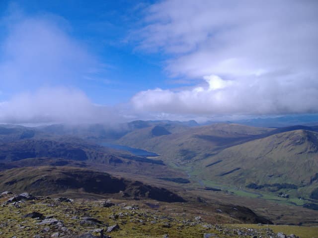
Meall Ghaordaidh (1039m) is the isolated whaleback Munro that rises between Glen Lochay and Glen Lyon, a substantial hill standing well clear of its Breadalbane neighbours. The summit gives one of the best panoramas in the Southern Highlands — Schiehallion to the north, the Lawers wall east, Ben More and Stob Binnein south, and the Crianlarich hills west. Despite its modest profile from the south, the hill demands a respectable day with steep grass climbs from every direction.
Quick facts
- Height
- 1039.8m/ 3411ft
- Prominence
- 492 m
- Distance
- 17 km
- Ascent
- 915 m
- Time
- 5–8 hrs
- Grid ref
- NN514397
- Parking
- NN531366
- Nearest
- Fort William· Stirling 54km
- Dogs
- Dogs on lead required near livestockDog-friendly guide ↗
Height and prominence cross-checked against the Database of British and Irish Hills (CC BY).
No GPX track yet
Walked this route? Share your track to help other walkers.
Standard route
Glen Lochay path 35% · Open hillside 40% · Summit 25%
Park in the small lay-by at Duncroisk on the Glen Lochay road, a few kilometres west of Killin. Walk north up the track behind the farm buildings, cross the burn and climb the long, grassy south ridge directly to the summit trig pillar and stone windbreak. Return the same way. Around 9km with 920m of ascent — a short, sharp day with a single substantial climb and no intermediate tops to break it up.
Terrain
The Duncroisk track is firm farm track for the first few hundred metres. The south ridge is open hillside with a clear path, mostly grass and short turf with occasional rocky outcrops higher up. The summit is a broad mossy dome with a trig pillar and a circular stone windbreak — welcome on a windy day. There is no scrambling or technical ground. The hill suffers from being trackless above the farm — pick a line in cloud carefully.
In winter
A relatively benign winter hill by Breadalbane standards but the open summit dome is fully exposed to easterly weather. The broad south ridge accumulates wind-blown snow under westerly weather; the north side of the summit develops persistent cornicing. The Glen Lochay road is narrow and can drift. Killin and the A827 corridor are reasonably maintained. SAIS Southern Cairngorms is the closest regional report.
Best time of year
Getting there
- Glasgow2h 47m
- Edinburgh2h 6m
OS maps: OS Landranger 51
Mobile signal: Reasonable signal at Killin. Signal fades above 700m on Meall Ghaordaidh. Cache maps ahead of leaving Killin.
Current conditions
Daylight Today
- Sunrise
- 05:02
- Sunset
- 21:46
- Civil dawn
- 04:08
- Civil dusk
- 22:40
NOAA Solar Calculator · 23 July 2026
Pair with
Curated multi-hill combinations from Meall Ghaordaidh.
Around Meall Ghaordaidh on the SCOT network
Getting there, basing yourself, and what to do off the hill.
Meall Ghaordaidh — common questions
- How hard is Meall Ghaordaidh?
- We grade Meall Ghaordaidh at 3/5, which puts it in moderately challenging territory. The usual route is around 17km with 915m of climbing; allow 5-8 hours. Ground conditions: The Duncroisk track is firm farm track for the first few hundred metres.
- How much drop does Meall Ghaordaidh have?
- The drop is 492m: measured from the summit of Meall Ghaordaidh down to the saddle joining it to higher terrain.
- Where's the parking for Meall Ghaordaidh?
- Park at NN531366 near Fort William. Double-check the grid reference on an OS map first; informal laybys here fill early in high season.
- What's the best month to climb Meall Ghaordaidh?
- Aim for May, June, July, August, September, October on Meall Ghaordaidh. In the remaining months treat it as a winter hill — full kit, solid navigation, and a look at the relevant SAIS avalanche forecast before you go.
- Can dogs go up Meall Ghaordaidh?
- Dogs are fine on a lead. The route passes livestock or ground-nesting bird habitat, so keep them close throughout.
- Will I get phone signal on Meall Ghaordaidh?
- Reasonable signal at Killin. Signal fades above 700m on Meall Ghaordaidh. Cache maps ahead of leaving Killin.
- Is Meall Ghaordaidh safe in winter?
- A relatively benign winter hill by Breadalbane standards but the open summit dome is fully exposed to easterly weather. The broad south ridge accumulates wind-blown snow under westerly weather; the north side of the summit develops persistent cornicing. The Glen Lochay road is narrow and can drift. Killin and the A827 corridor are reasonably maintained. SAIS Southern Cairngorms is the closest regional report.
Get the OutdoorSCOT weekly
One email a week — new route, hill and bothy guides, seasonal conditions and the odd hard-won lesson. No spam, unsubscribe in one click.