Corbett · Fife & Perthshire
Meall nan Subh
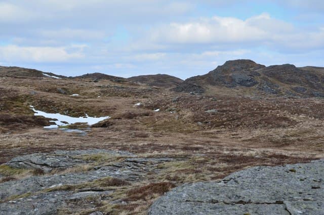
Meall nan Subh — "hill of the berries", a reference to the cloudberries that ripen on its slopes in late summer — is a rounded Corbett at the head of Glen Lochay, sharing the watershed with Meall Buidhe to the south-east. At 806m the summit is an embedded boulder beside a small cairn on a wide grassy dome, with a fine view east toward the Lawers range and west into the Mamlorn Munros. The hill is often combined with Meall Buidhe for a Glen Lochay watershed double.
Quick facts
- Height
- 806m/ 2644ft
- Prominence
- 214 m
- Distance
- 15 km
- Ascent
- 709 m
- Time
- 4–7 hrs
- Grid ref
- NN460397
- Parking
- NN465360
- Nearest city
- Fort William· 49km
- Dogs
- Dogs on lead required near livestockDog-friendly guide ↗
Height and prominence cross-checked against the Database of British and Irish Hills (CC BY).
No GPX track yet
Walked this route? Share your track to help other walkers.
Standard route
hydro road 45% · open hillside 30% · broad ridge 15% · summit boulder 10%
Drive to the locked gate at Kenknock in upper Glen Lochay and continue west on foot or by bike along the hydro road over the Lairig nan Lunn. From the top of the pass, leave the road and climb open grass and heather slopes east-south-east onto the broad north ridge of Meall nan Subh. The ridge gives a gentle pull to the summit dome. Around 15km return with 709m of ascent; combining with Meall Buidhe adds a couple of kilometres.
Terrain
The Lairig nan Lunn hydro road is firm gravel and easy on a bike. Past the gravel road the hillside is open grass and heather; the climb to the dome is gentle and short. The summit dome is wide mossy turf with the embedded boulder cairn on the high point. Neither exposure nor scrambling anywhere. The connecting ridge south to Meall Buidhe is easy walking.
In winter
A benign winter Corbett — gentle gradients, no avalanche slopes, no cornicing on the broad dome. The Lairig nan Lunn pass road can drift up and the Glen Lochay road from Killin is single-track and rarely gritted in its upper reaches. The hill itself is straightforward; bike approach less viable under snow.
Best time of year
Getting there
- Glasgow2h 48m
- Edinburgh2h 12m
OS maps: OS Landranger 51
Mobile signal: Zero signal in upper Glen Lochay; intermittent at Kenknock
Current conditions
Daylight Today
- Sunrise
- 04:46
- Sunset
- 22:01
- Civil dawn
- 03:47
- Civil dusk
- 23:00
NOAA Solar Calculator · 13 July 2026
Pair with
Curated multi-hill combinations from Meall nan Subh.
Around Meall nan Subh on the SCOT network
Getting there, basing yourself, and what to do off the hill.
Meall nan Subh — common questions
- What difficulty is Meall nan Subh?
- On the OutdoorSCOT scale, Meall nan Subh comes in at 3/5 — moderately challenging. Expect roughly 15km and 709m of ascent on the usual route — 4-7 hours for most parties. Terrain: The Lairig nan Lunn hydro road is firm gravel and easy on a bike.
- How prominent is Meall nan Subh?
- Meall nan Subh has 214m of topographic prominence — the height of its summit above the highest col connecting it to higher ground.
- Where should I park to climb Meall nan Subh?
- Standard parking is at NN465360. Check the parking grid reference on an OS map before travel; informal laybys can fill on summer weekends.
- When should I climb Meall nan Subh?
- The standard good-weather months for Meall nan Subh are April, May, June, July, August, September, October. Outside those months, expect winter conditions on the high ground — full mountain kit, navigation skills, and a check of the SAIS avalanche forecast for the relevant region.
- Can I bring my dog up Meall nan Subh?
- On a lead only — the route crosses ground with livestock or nesting-bird interest.
- What's mobile reception like on Meall nan Subh?
- Zero signal in upper Glen Lochay; intermittent at Kenknock
- Is Meall nan Subh safe in winter?
- A benign winter Corbett — gentle gradients, no avalanche slopes, no cornicing on the broad dome. The Lairig nan Lunn pass road can drift up and the Glen Lochay road from Killin is single-track and rarely gritted in its upper reaches. The hill itself is straightforward; bike approach less viable under snow.
Get the OutdoorSCOT weekly
One email a week — new route, hill and bothy guides, seasonal conditions and the odd hard-won lesson. No spam, unsubscribe in one click.