Munro · Fife & Perthshire
Beinn Achaladair
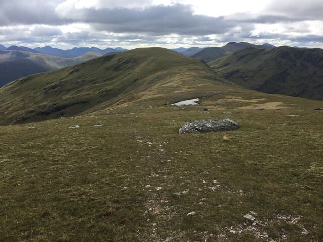
Beinn Achaladair (1038m) is the second-highest of the four Bridge of Orchy Munros, sitting between Beinn an Dòthaidh to the west and Beinn a' Chreachain to the east. The hill's steep south-west face plunges 700m straight into Coire Achaladair above the West Highland Line, giving it the most striking profile of the four. The traverse from Achallader, taking in Achaladair and Chreachain, is one of the classic Highland Munro pairings.
Quick facts
- Height
- 1038.6m/ 3407ft
- Prominence
- 226 m
- Distance
- 17 km
- Ascent
- 914 m
- Time
- 5–8 hrs
- Grid ref
- NN344432
- Parking
- NN322443
- Nearest city
- Fort William· 39km
- Dogs
- Dogs on lead required near livestockDog-friendly guide ↗
Height and prominence cross-checked against the Database of British and Irish Hills (CC BY).
No GPX track yet
Walked this route? Share your track to help other walkers.
Standard route
Farm track 25% · Open hillside 35% · Long ridge 40%
Start from Achallader Farm just off the A82 west of Bridge of Orchy. Follow the estate track east under the railway viaduct, then climb steeply up Coire Achaladair on a clear path to the high bealach between Achaladair and Chreachain. Turn west along the narrow south-east ridge to the small summit cairn. Most parties continue over Beinn a' Chreachain returning via the Crannach woods. Around 17km with 1100m of ascent for the pair.
Terrain
The Achallader estate access is firm landrover track for the opening couple of kilometres. The Coire Achaladair path is steep and rough, well-trodden but eroded in places. The summit ridge of Achaladair is narrow rocky crest with significant exposure on the south side. The connecting ridge to Chreachain involves a steady drop and steady climb on broad turf. The south-west face cliffs come close to the summit path — take care in cloud.
In winter
A serious Bridge of Orchy winter ridge. The south-west face becomes avalanche-prone under westerly storm loading; the summit ridge develops persistent cornicing on its south side. The Coire Achaladair path is exposed to driven snow. The Achallader access track can be drifted but the A82 corridor is gritted. Phone signal absent above 700m. SAIS Glencoe is the nearest formal report.
Best time of year
Getting there
- Glasgow2h 44m
- Edinburgh2h 26m
OS maps: OS Landranger 50
Mobile signal: Signal vanishes above 700m. Bridge of Orchy has 4G. Sort maps before heading out from Achallader.
Current conditions
Daylight Today
- Sunrise
- 05:03
- Sunset
- 21:48
- Civil dawn
- 04:09
- Civil dusk
- 22:42
NOAA Solar Calculator · 23 July 2026
Pair with
Curated multi-hill combinations from Beinn Achaladair.
Around Beinn Achaladair on the SCOT network
Getting there, basing yourself, and what to do off the hill.
Getting there: Bridge of Orchy station
Black Mount; Beinn Dorain, Beinn an Dothaidh, Beinn Achaladair, Beinn a Chreachain
6km from the hill
tripscot.co.uk
On TripSCOTBase yourself in Fort William
Ben Nevis base, West Highland Line, gateway to Lochaber
39km from the hill
tripscot.co.uk
Beinn Achaladair — common questions
- Is Beinn Achaladair a hard climb?
- Beinn Achaladair is rated 4/5 (challenging) on the OutdoorSCOT scale. The standard route covers about 17km with 914m of ascent and takes most walkers 5-8 hours. Terrain: The Achallader estate access is firm landrover track for the opening couple of kilometres.
- How prominent is Beinn Achaladair?
- Beinn Achaladair has 226m of topographic prominence — the height of its summit above the highest col connecting it to higher ground.
- Where should I park to climb Beinn Achaladair?
- Standard parking is at NN322443. Check the parking grid reference on an OS map before travel; informal laybys can fill on summer weekends.
- When should I climb Beinn Achaladair?
- The standard good-weather months for Beinn Achaladair are May, June, July, August, September, October. Outside those months, expect winter conditions on the high ground — full mountain kit, navigation skills, and a check of the SAIS avalanche forecast for the relevant region.
- Can I bring my dog up Beinn Achaladair?
- On a lead only — the route crosses ground with livestock or nesting-bird interest.
- What's mobile reception like on Beinn Achaladair?
- Signal vanishes above 700m. Bridge of Orchy has 4G. Sort maps before heading out from Achallader.
- Is Beinn Achaladair safe in winter?
- A serious Bridge of Orchy winter ridge. The south-west face becomes avalanche-prone under westerly storm loading; the summit ridge develops persistent cornicing on its south side. The Coire Achaladair path is exposed to driven snow. The Achallader access track can be drifted but the A82 corridor is gritted. Phone signal absent above 700m. SAIS Glencoe is the nearest formal report.
Get the OutdoorSCOT weekly
One email a week — new route, hill and bothy guides, seasonal conditions and the odd hard-won lesson. No spam, unsubscribe in one click.