Graham · Glen Coe & Lochaber
Beinn nan Lus
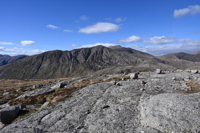
Beinn nan Lus (709m) — the hill of the herbs — at NN13 stands in the wedge of country between Loch Etive and Glen Kinglass, surrounded by famous Munros like Stob Coir' an Albannaich and Meall nan Eun. The summit cairn perches above the head of Glen Kinglass with sightlines south-west down Etive's long inlet and east toward the snow-streaked Cruachan tops. A rarely-climbed Graham hidden by giants.
Quick facts
- Height
- 709m/ 2326ft
- Prominence
- 240 m
- Distance
- 13 km
- Ascent
- 581 m
- Time
- 3–6 hrs
- Grid ref
- NN130375
- Parking
- NN135394
- Nearest city
- Oban· 28km
- Dogs
- Dogs on lead required near livestockDog-friendly guide ↗
Height and prominence cross-checked against the Database of British and Irish Hills (CC BY).
No GPX track yet
Walked this route? Share your track to help other walkers.
Standard route
heather and bracken 55% · grass slopes 30% · rocky summit 15%
Approach from the head of Glen Etive (Loch Etive end), tracking south-east across the Allt Mheuran into a boggy bealach, then climbing the broad north-west shoulder. Alternative access from Victoria Bridge via the Glen Kinglass landrover track makes a much longer day. 13km return on the standard line, 581m of climbing — short but committing because of river crossings.
Terrain
The Allt Mheuran river is unbridged and dangerous in spate — pick visit days carefully. Above the river, deer-grass and tussock dominate to about 500m before short turf and granite chips on the upper dome. The summit cairn is on a broad shoulder; care needed to locate the true top in cloud.
In winter
Etive-Kinglass watershed catches Atlantic moisture and snow lies on the broad bealach into March most years. The river crossing becomes the crux of any winter visit — even normal flows are dangerous when iced. SAIS Glencoe forecasts cover the surrounding hills and apply here in spirit.
This hill is in the Glen Coe SAIS forecast area. Check SAIS forecasts in winter (December–April).
Best time of year
Getting there
- Glasgow2h 49m
- Edinburgh3h 45m
OS maps: OS Landranger 50
Mobile signal: Poor in Glen Etive head; weak signal returns on the summit toward the Cruachan masts.
Current conditions
Daylight Today
- Sunrise
- 04:48
- Sunset
- 22:03
- Civil dawn
- 03:50
- Civil dusk
- 23:02
NOAA Solar Calculator · 13 July 2026
Around Beinn nan Lus on the SCOT network
Getting there, basing yourself, and what to do off the hill.
Getting there: Loch Awe station
East shore Loch Awe; Ben Cruachan; Kilchurn Castle
10km from the hill
tripscot.co.uk
On TripSCOTBase yourself in Oban
Argyll ferry hub — Mull, Lismore, Coll, Tiree, Barra
28km from the hill
tripscot.co.uk
On TasteSCOTAfter the hill: Oban
Oban town centre — tiny two-still distillery bridging Highland and West Coast styles
28km from the hill
tastescot.co.uk
Beinn nan Lus — common questions
- How hard is Beinn nan Lus?
- We grade Beinn nan Lus at 3/5, which puts it in moderately challenging territory. The usual route is around 13km with 581m of climbing; allow 3-6 hours. Ground conditions: The Allt Mheuran river is unbridged and dangerous in spate — pick visit days carefully.
- How much drop does Beinn nan Lus have?
- The drop is 240m: measured from the summit of Beinn nan Lus down to the saddle joining it to higher terrain.
- Where's the parking for Beinn nan Lus?
- Park at NN135394. Double-check the grid reference on an OS map first; informal laybys here fill early in high season.
- What's the best month to climb Beinn nan Lus?
- Aim for April, May, June, July, August, September, October on Beinn nan Lus. In the remaining months treat it as a winter hill — full kit, solid navigation, and a look at the relevant SAIS avalanche forecast before you go.
- Can dogs go up Beinn nan Lus?
- Dogs are fine on a lead. The route passes livestock or ground-nesting bird habitat, so keep them close throughout.
- Will I get phone signal on Beinn nan Lus?
- Poor in Glen Etive head; weak signal returns on the summit toward the Cruachan masts.
- Is Beinn nan Lus safe in winter?
- Etive-Kinglass watershed catches Atlantic moisture and snow lies on the broad bealach into March most years. The river crossing becomes the crux of any winter visit — even normal flows are dangerous when iced. SAIS Glencoe forecasts cover the surrounding hills and apply here in spirit.
Get the OutdoorSCOT weekly
One email a week — new route, hill and bothy guides, seasonal conditions and the odd hard-won lesson. No spam, unsubscribe in one click.